All hydrogeological exploration work is predicated upon a comprehensive geological assessment of the watershed. Consequently, an initiative was undertaken to update the geological map of the Benoue upstream watershed (BUW), with the objective of facilitating future characterization of the aquifers in this basin. To this end, Landsat OLI and SRTM satellite images of paths 155 and 055 were employed to discriminate the lithology through the use of multiple methods, including color composition, principal component analysis (PCA), band ratio, and MNF analysis. In Addition, borehole logs, when examined through their cross-sections, facilitated the establishment of these correlations. The results of the processing operations are then compared with the Ngaoundere East geological map (1961) in order to provide guidance with regard to lithological discrimination, and with the 2021 geological map. To corroborate the final rendering, a field campaign is conducted to geolocate the geological formations at critical points and superimpose them on indices obtained through processing, thus facilitating the final perfection of the map. In total, six geological facies have been mapped at a scale of 1:50,000, forming the basis for future work.
A historical overview of the geological work conducted in Cameroon can be summarized as follows: Prior to independence, extensive geological mapping was conducted by BUMIFOM, now known as BRGM and numerous university researchers, resulting in the publication of several 1:500,000 scale geological maps 1. Additionally, preliminary work was conducted during the German colonial period until the eve of World War I, resulting in the publication of geological sketches at 1:500,000 and the discovery of certain mineral occurrences and deposits, including rutile in 1908. In 1979, the 1:1,000,000 geological map was published, providing a synthesis of the sixteen 1:500,000 reconnaissance sections, accompanied by an explanatory note in 1986. Furthermore, the map of 2001 by 2 and the 1:1,000,000 map of 2021 by the Ministry of Mines, Industry and Technological Development have been published. Over time, these diverse works have highlighted groups of geological formations and their characterization according to geomorphological domains. The basement of the Adamaoua plateau is composed of metamorphic rocks of Paleoproterozoic age (2.1 billion years) 3, 4, 5, which have been intensely remobilized by the Pan-African orogeny 2, 6.
The area is intruded by numerous granitoid intrusions, with an age range of 615 ± 27 to 575 million years 5, 7. Additionally, post-Pan-African dolerite dykes are present 8. Recent research in the Meiganga region has been conducted by 9 on the petrography and structure of the Goumbela locality and by 10 on the geothermal potential of the Kaladi locality. 11, 12 conducted a study of the syntectonic plutons of the Tibati region. These include diorites, tonalites, granodiorites, and granites that were emplaced along the Central Cameroon Shear. In the Meiganga pyroxene-amphibole gneisses, 5 demonstrate the presence of geochemical and 207Pb/206Pb age fingerprints that can be attributed to the Archean legacy. The structural, petrographic, and geochemical data on the Ngaoundere granites led 7 to the conclusion that these rocks were emplaced in a syn- or post-collisional environment. The study area has not been the subject of extensive research to date. The available data encompass the study area and are derived from academic research or one-off hydrogeological explorations 13, 14. This situation rationally reinforce the undertaking of this study to update the geological map at a detailed scale for the area in question. The existing regional geological maps reflect outmoded concepts that fail to incorporate contemporary geological, geophysical, or geochemical knowledge and survey methods. However, the 2021 geological map was produced using geochemical approaches.
The objective of this study is to compensate the absence of a comprehensive basin-wide geological map by employing optical remote sensing, which represents a rapid, precise, and cost-effective geological mapping technique in the present era. As evidenced by the work of authors such as 15, 16, 17, remote sensing and GIS have been employed to map or update geological maps, as well as to create lineament maps. This tool is employed in conjunction with field observations for the purpose of geological exploration within the upstream Benoue watershed. In particular, the objective is to:
- Identify the principal petrographic units through image processing;
- Compare the processing results with previous research and field observations;
- Produce an updated geological map of the upstream Benoue watershed.
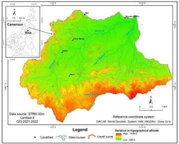
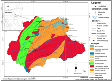
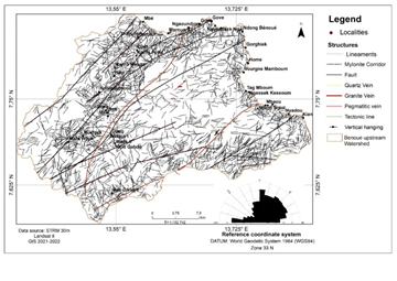
The study area, situated to the southeast of the Mbé council (see Figure 1), represents a watershed. The area in question encompasses 903.69 km², with a perimeter of 163.77 km. The area is situated between longitudes 13.406°E and 13.835°E and latitudes 7.567°N and 7.875°N. The River Benoue is the main collector which flows uninterrupted, thus justifying the designation of the "Benoue Upstream Watershed." The area is distinguished by a dendritic hydrographic network, exhibiting a pronounced prevalence of spasmodic flow. The climate is classified as dry tropical. The area is distinguished by irregularities in both space and time, as well as a notable range in annual precipitation, which falls between 600 and 1,000 mm. The mean annual temperature is approximately 25°C in April (the hottest month) and 19°C in December (the coldest month) 18, 19.
From a geomorphological perspective, the basin's relief can be described as a peneplain, situated within the northern edges of the Ngaoundere escarpment. The landscape is punctuated by the occasional butte and rocky hill, which have been eroded by wind and water. The slope of the terrain ranges from 0 to 10%. The region's peak altitudes range from 1,150 to 1,400 meters, while its average altitudes are between 750 and 1,100 meters. The region is marked by the presence of small relief domes. The valleys, which are drained during periods of flooding are located in low land areas (altitude between 450 and 700 meters).
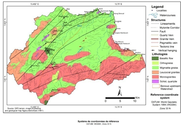
From a geological and structural standpoint, the upstream Benoue watershed is situated within the central Adamaoua-Yade zone. The area is bounded to the north by the Tcholire-Banyo shear zone and to the south by the Sanaga fault 5, 20. The work of 7 on the Ngaoundere granitoids, in conjunction with that of 21, as well as an examination of historical cartographic materials, specifically the geological map of Ngaoundere from 1961, enabled the identification of eight distinct geologic facies: basalts, granites, gneisses, and differentiated formations (embrechists, anatexites).
To accomplish this task, a variety of tools and data sets were employed. These included the Landsat OLI image of January 28, 2021, captured from paths and rows 185 and 055; a topographic map; an older geological map; and SRTM images of the aforementioned paths and rows. The Global Positioning System (GPS) receiver was employed to determine the geographic coordinates of the hydraulic structures. The utilisation of software such as Word, Excel, Erdas and ArcGIS enabled the processing, digitisation and production of cartographic information.
The rationale decision behind the utilization of Landsat 8 is due to its multispectral radiometer, which encompasses spectral bands spanning from the visible to the mid-infrared, in contrast to the outcomes observed in previous Landsat series. Furthermore, two additional bands have been incorporated, providing atmospheric correction (the blue band at 440 m) and cloud detection (the 1380 m band), in addition to a quality assessment (QA) band where each pixel contains a decimal value. Upon transformation of this value into a 16-bit binary number, the ability to detect specific details of the Earth's surface, subsoil, and atmosphere is enabled.
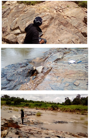
3.2. MethodsThe field data collection stage entails the geo-localisation of geological formations and the measurement of attitudes, with the objective of constructing a geological database that will be employed to validate the geological model obtained subsequent to processing.
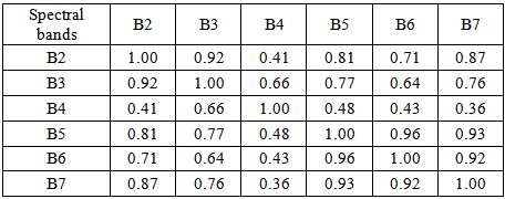
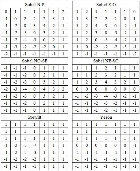
The image pre-processing, which was conducted as part of the work presented in reference 20, served to establish the link between watershed structures and the production of hydraulic structures. The geological bodies were distinguished by identifying the optimal composites through the IOF calculation (Table 2, Table 4, Table 7, and Table 9), which was based on the correlation matrix (Table 1, Table 3, Table 6, and Table 8). The mapping of linear structures was achieved through the utilisation of directional filtering with 7x7 convolution matrices.
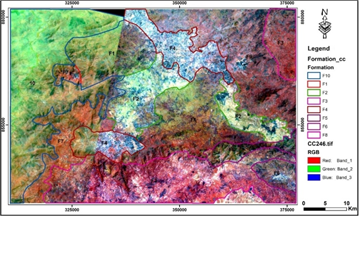
Remote sensing images are in raster mode and are expressed in pixels. Each pixel contains a radiometric value, which provides information regarding the brightness and color of the feature in question. A raster file is composed of one or more-color channels. Each image is associated with a particular spectral band, reflecting the band in which it was acquired. The variety of Landsat channels provides numerous possibilities for band combinations. It is not uncommon for the information contained in the bands to be repetitive. To address this repetitiveness and identify the most salient RGB compositions, a statistical analysis of the bands within the metafile is conducted. The correlation matrix (see Table 1) was employed to calculate the correlation coefficient and associated deviations. The combination with the highest OIF is likely to provide the most lithological information, as it employs data with the fewest redundancies. Furthermore, the Index Factor Optimum is calculated.
The formula is as follows: OIF= (1)
(1)  , The sum of the standard deviations of the combinations of the three bands (k1, k2, k3) is presented herewith. The sum of the absolute values of the correlation coefficient.
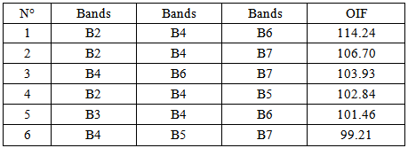
The correlation matrix facilitated the calculation of the IOF and the identification of the optimal combination. The result of this calculation (see Table 2) demonstrates that the 2-4-6 combination exhibits the optimal IOF.
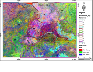
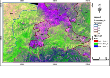
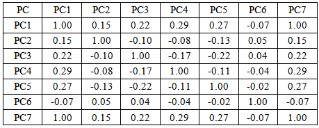
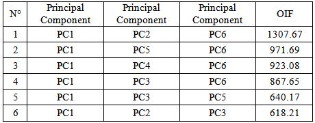
Principal component analysis (PCA) is a mathematical transformation that involves calculating the eigenvalues and eigenvectors of the variance-covariance matrix derived from a series of images. This is followed by the calculation of the principal components of the multispectral band count 22. The bands were correlated (Table 3) in order to calculate the IOF (Table 4). The results demonstrate that the optimal combination is 1-2-6.
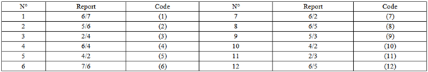
Band ratio is a technique for dividing the digital counts of one band by another, thereby facilitating the discrimination of the desired feature according to its reflectance 23. It can also elucidate information obscured by topography. In this study, 12-band ratios were employed for the purpose of identifying lithological units and mineral bodies (see Table 5). The radiometric behavior of a given body is recorded as a function of the wavelengths that are crossed. The selection of bands is contingent upon the specific absorbance and reflectance characteristics of the element in question.
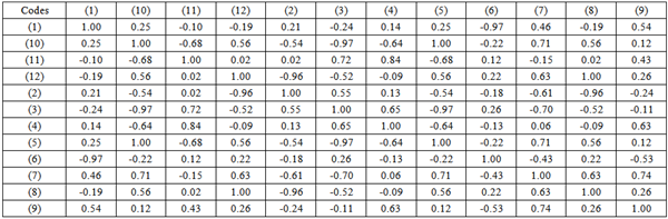
The aforementioned products were combined in order to produce the most optimal composites, as determined by the IOF calculation utilizing the correlation matrix (Table 6).
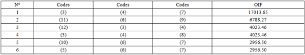
The outcome of the IOF calculation permitted the consolidation of ratios (3), (4), and (7), which yielded the optimal result (see Table 7).
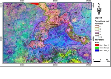
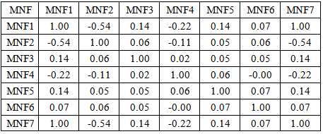
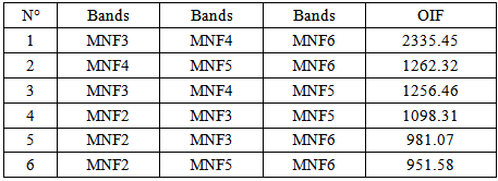
The Minimum Noise Fraction (MNF) analysis is employed to discern variations between bands in an image and to identify anomalous spectral features. This analysis is of significant importance in the field of mineral resource prospecting 24. Additionally, MNF transformation is employed to ascertain the intrinsic dimensionality of image data, thereby enabling the isolation of noise and the reduction of computational demands for subsequent processing 25. It is a method that is analogous to or similar to principal component analysis (PCA), which involves the preparation of the principal components in accordance with the information they contain. As stated by 26, the initial MNF bands encompass signals, while the subsequent bands comprise noise. A MNF transformation was applied to the near-infrared (PIR) and mid-infrared (MIR) bands, and the resulting data were correlated (see Table 6). To generate the color compositions, the OIF was calculated. The combination of bands with the optimal OIF was selected for this phase (Table 7).
The results indicate that the most significant combination is MNF3-MNF4-MNF6.
The application of remote sensing technology and GIS has been demonstrated to be an effective approach for the mapping of geological lineaments 21, 27, 28, 29 30, 31, 32, 33, 34. To achieve this mapping, a number of operations are required. The work of 20, 34, 35 presents these different operations in detail. For this case study, the steps involved in producing the BUW fracturing map are clearly defined in the work of 21, which should be consulted as a reference. The digitization of linear structures is achieved through the use of 7 x 7 convolution matrices, as demonstrated in 21, 47, 48 (Table 10). The various stages that facilitated the mapping of the BUW structure are illustrated in Figure 8 below.
This stage validates the results obtained from image processing by analysing and superimpose on field data. It consists in building a geological database from field observations in order to refine the final geological map. The work of 21 clearly defines the methods used to validate lineament mapping as a fracture map of the BVAB. The geological mapping was highlighted using geo-localized field observations (lithological nature, pedological contrast, etc.) combined with the image-processing synthesis map and correlated with old maps.
geo-localized field observations (lithological nature, pedological contrast, etc.) combined with the image-processing synthesis map and correlated with old maps.
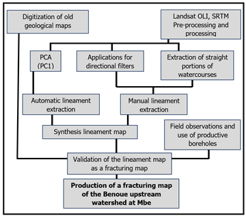
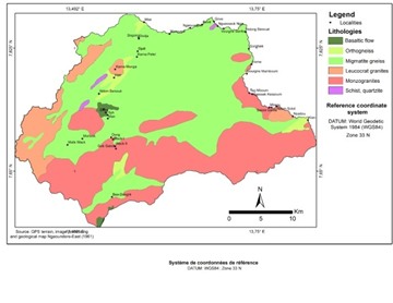
Figure 11 illustrates the outcomes of the processing and validation procedures. The results demonstrate the presence of six distinct geological facies, including gneiss (orthogneiss and migmatitic gneiss), granite (monzogranite and leucocrate granite), and schist, in addition to basaltic flows. The BUW is predominantly composed of gneiss.
Following enhancement and the application of filters (Sobel, Prewitt, and Yesou), a total of 5,343 fractures of varying directions and lengths were mapped 21. The work of these authors has enabled the classification of these structures by direction using the directional rosette. The major directions are observed in the northeast quadrant, while the minor directions are observed in the northwest quadrant.
The updating of the BUW geological map was made possible by the application of appropriate processing methods (CC, ACP, RP, MNF, and filtering), in conjunction with field campaigns and correlation with previous research. The details observed on the map provide evidence of significant geological phenomena, including faults, fractures, and evidence of volcanism and geological contacts that are likely to influence the infiltration and flow of groundwater towards the BUW aquifers. However, linear extraction methods that employ directional filtering and the extraction of rectilinear portions of watercourses have been demonstrated to be both time- and cost-efficient. The quality of the information obtained is contingent upon the quality of the processing applied to the image utilized. As stated by 37, the object-oriented analysis of SRTM radar interferometry images allows for the automatic and efficient extraction of reliable information, thereby providing a foundation for sound management decisions in hydrogeological studies.
An analysis of the lineaments and directional rosettes indicates the presence of significant north-south deformation, with a predominant direction of N005°E. Furthermore, the N065° and N075° directions are also of significance, exhibiting a close alignment with the overall deformation orientation of the N70°E Adamaoua-Yadé corridor, which has an international extension 38, 39, 40. The orientation of the fractures is a critical factor in determining their potential hydraulic role. It is possible for fractures to be open in one direction and closed in another. The field campaign facilitated observation of the alignment of mylonites, thereby substantiating the existence of the fault in the headwaters of the Benoue stream.
The methodologies employed to obtain the geological and structural results presented in this study are consistent with those utilized by other researchers in the field of geological and lineament map updating 15, 17, 33 34, 41, 42 43, 44, 45 46, 48.
Geographic information systems (GIS) and remote sensing play a pivotal role in advancing geological studies. In this instance, the geological entities of lithology, tectonics, and magmatism are elucidated through the presentation of vector-based information layers. This is achieved through the acquisition, processing, analysis, and interpretation of Landsat 8 images, as illustrated in figure 9, 10, and 11. This has enabled us to more accurately delineate the geological contours of the various formations and to more precisely identify the lineaments. This process has enabled the updating of the BUW geological map and the establishment of a correlation between aquifer production and the geological nature of the area. In terms of geology, three principal formations have been identified and mapped, exhibiting a range of facies: gneissic formations, granitic formations, and schist formations.
The author would like to express his sincere gratitude to his thesis supervisor, Prof. Ewodo Mboudou Guillaume, for his special dedication and for ensuring that the various objectives of this research were achieved, as well as for his remarkable support throughout the completion of this work. I would also like to thank all the other co-authors: Mr Messi Gabriel, Mr Mohamadou Mouctar, Dr Diguim Kepnamou Amadou and Prof. Kah Elvis Fang, who assisted me in the production of this work.
| [1] | Koch, P., Carte géologique du Cameroun à l’échelle du 1/500.000, Garoua Ouest.Dir. 1959. Mines Géol. Cameroun, Yaoundé, 1 carte avec notice. | ||
| In article | |||
| [2] | Toteu, S.F., Van Schmus W.R., Penaye J., et Michard A., New U–Pb and Sm–Nd data from North-Central Cameroon and its bearing on pre-Panafrican history of central Africa. 2001. Precambrian Research, 108, 45-73. | ||
| In article | View Article | ||
| [3] | Toteu S.F., Penaye J., Van Schmus W.R., Michard A., Preliminary U–Pb and Sm– Nd geochronologic data on the North-Central Cameroon: contribution of an Archean and paleo-Proterozoic crust to the edification of an active domain of the Pan-African orogeny. 1994. C. R. Acad. Sci. Paris, Sér II 319, 1519–1524. | ||
| In article | |||
| [4] | Penaye, J., Toteu S.F., Tchameni R., Van Schmus W.R., Tchakounté J., Ganwa A., Minyem D. and Nsifa, E.N. (2004) The 2.1 Ga West Central African Belt in Cameroon: Extension and Evolution. Journal African Earth Sciences, 39, 159-164. | ||
| In article | View Article | ||
| [5] | Ganwa, A. A., Wolfgang F., Wolfgang S., Ekodeck G.E., Cosmas Kongyuy S., Ngako V., Archean inheritances in the pyroxene–amphibolebearing gneiss of the Meiganga area (Central North Cameroon): Geochemical and 207Pb/206Pb age imprints. 2008b. | ||
| In article | View Article | ||
| [6] | Lasserre, M., Soba, D., Migmatisation d'âge Panafricain au sein des formations précambriennes appartenant à la zone mobile d'Afrique Centrale, 1979.C. R. somm. Séances Soc. Géol. France 2, 64–68. | ||
| In article | |||
| [7] | Tchameni, R., Pouclet A., Penaye J., Ganwa A.A., Toteu S.F., Petrography and géochemistry of the Ngaoundere Pan-African granitoïds in Central Nord Cameroon: implication for their sources and geological setting. 2006. Journal of African Earth Sciences 44, pp. 511-529. | ||
| In article | View Article | ||
| [8] | Vicat, J.-P., Ngounouno I., Pouclet A., Existence de dykes doléritiques anciens à composition de tholéiites continentales au sein de la province alcaline de la ligne du Cameroun. Implication sur le contexte géodynamique. 2001. C. R. Acad. Sci. Paris, Sci. Terre Planèt. 332, 243–249. | ||
| In article | View Article | ||
| [9] | Ngo Ngomb, A. P., Contribution à l’étude pétrographique et structurale de la région de Goumbela. 2005. Mémoire de Maîtrise en science de la terre. | ||
| In article | |||
| [10] | Moustapha, N., Arsène, M., Alain, Z., Raouf, A. et Demianus, N. Etude du potentiel géothermique de la localité de Kaladi et ses environs (Adamawa-Cameroun) à partir du traitement fréquentiel de Données magnétiques.2022. Revue Internationale des geosciences, 13, 1024-1039. est-ce que je: 10.4236/ ijg. 2022.1311052. | ||
| In article | View Article | ||
| [11] | Njanko, T., Nedelec A., Affaton P., Synkinematic high-K calc-alkaline plutons associated with the Pan-African Central Cameroon shear zone (W-Tibati area): Petrology and geodynamic significance. 2006. Journal of Africa Earth Sciences 44, 494–510. | ||
| In article | View Article | ||
| [12] | Kapajika, B., Wörner, G., Lubala, R.T., Hartman, G., Simon, K., Kronz, A. Geodynamic significance of syntectonic granitoids from W-Tibati area in the North-Equatorial Pan-African fold Belt (Cameroon). 2008. Annales des Sciences. Université Officielle de Bukavu. Vol. 1 (1): 2008. | ||
| In article | |||
| [13] | Zo’o Zame, P., Nzeukou Nzeugang, A., Uphie Chinje, M., Mache, J.R., Ndifor, D.A. and Nni, J. Mapping and Geotechnical Characterization of Some Local Construction Materials for the Adamawa Region of Cameroon. 2016. British Journal of Applied Science & Technology, 17, 1-13. | ||
| In article | View Article | ||
| [14] | Souaibou., Elimbi,A., Danwe,R. (2019) Influence of the Colorless Waste Glass on the Mineralogical, Microstructural and Mechanical Properties of Clay Material from Wack (Adamawa, Cameroon). Advances in Materials Physics and Chemistry, 9, 89-102. | ||
| In article | View Article | ||
| [15] | Kah, E., Innocent, N.M. and Gilles, Z.M. (2020) Combined Methods of Remote Sensing and Fieldwork in Geological and Mineral Exploration in the Mballe Locality, Adamawa Region of Cameroon. Natural Resources, 11, 184-203. | ||
| In article | View Article | ||
| [16] | Mbaigane, D. J. C., Penyaye J., Kagou A, Diondoh M.S., Vidal M et Pouclet A. (2011). Apport de la télédétection à l’étude structurale de la région du mayo kebbi (sud-ouest du Tchad). Bulletin du Service Géologique National Vol. 22, n° 2, pp. 187 - 198, 7 fig., 2011. | ||
| In article | |||
| [17] | Gharmane, Y., El Fartati M., Amrani S., Hinaje S. (2018). Mise À Jour De La Cartographie Géologique Et États Des Contraintes Tectoniques Dans La Zone De Bouchfâa (NW Du Massif De Tazekka, Maroc). European Scientific Journal June 2018 edition Vol.14, No.18 ISSN: 1857 – 7881 (Print) e - ISSN 1857- 7431. | ||
| In article | View Article | ||
| [18] | Suchel J.B., 1972. La répartition et les régimes pluviométriques au Cameroun. Travaux et documents de géographie tropicale n°5. CEGET-CNRS, Bordeaux, 283 p. | ||
| In article | |||
| [19] | Suchel J.B., 1987. Les climats du Cameroun. Thèse. Doc. d'Etat, Université de Bordeaux III. France, 1186 p. Oumarou Faarouk NKOUANDOU, Ismaïla NGOUNOUNO et Bernard DERUELLE. Int. J. Biol. Chem. Sci. 4(4): 984-1003, August 2010. Géochimie des laves basaltiques récentes des zones Nord et Est de Ngaoundéré (Cameroun, Plateau de l’Adamaoua, Afrique centrale): pétrogenèse et nature de la source. | ||
| In article | View Article | ||
| [20] | Dumont, J. P., (1987). Etude structurale des bordures Nord et Sud du plateau de l’Adamaoua : Influence du contexte atlantique. Géodynamique2, ORSTOM, Lima, apartado18, 1209.55-68Dynamique. N°4; 145-160. | ||
| In article | |||
| [21] | Oumarou Baba, N., Amadou, D. K., & Guillaume, E. M. (2024). Cartographie des fractures productives en eau souterraine dans le bassin versant de la Bénoué : apport de la géomatique. European Scientific Journal, ESJ, 33, 246. Retrieved from https:// eujournal.org/ index.php/esj/article/view/18562. | ||
| In article | |||
| [22] | Bonn F et al., 1992. Précis de Télédétection. Principes et méthodes. Presse de l’université de Québec / AUPELF, vol. 1, 485 p. | ||
| In article | |||
| [23] | Pour, A., et Hashim, M., 2015. Hydrothermal alteration mapping from Landsat-8 data, Sar Chesmeh copper mining district, south-eastern Islamic republic of Iran. Journal of Taibah University for Science, 9, 155-166p. | ||
| In article | View Article | ||
| [24] | Mouhssine, W et al., 2013. Traitement numérique d’image aster pour l’identification des zones d’altération hydrothermales associées au skarn d’Azegour. | ||
| In article | |||
| [25] | Boardman, J.W. and Kruse. F.A., 1994. Automated spectral analysis: A geological example using AVIRIS data, Northern Grapevine Mountains, Nevada: In Proceeding Tenth Thematic Conference. Geological Remote Sensing, 9-12 May, San Antonio, Texas, 407-418. | ||
| In article | |||
| [26] | Mouhssine WAHI, Kamal TAJ-EDDINE, Noureddine LAFTOUHI.Geotunis 2013. Traitement numérique d’image aster pour l’identification des zones d’altération hydrothermales associées au skarn d’Azegour. | ||
| In article | |||
| [27] | Savané, I.; Gozé B.; Biémi J. (1995). Evaluation des ressources en eau dans le socle par l’étude des fractures à l’aide des données Landsat (Bassin d’Odienné, Côte d’Ivoire). Télédétection et Gestion des ressources en Eau, Colloque FAO, Montpellier, 29 Nov. au 01 Dec. 1995. | ||
| In article | |||
| [28] | Biemi, J., Deslandes, S., Gwyn, Q. H. J., Jourda, P. (1991). Influence des linéaments sur la productivité des forages dans le bassin versant de Ta Haute Marahoué (Côte d'Ivoire) : Apport de la télédétection et d'un système d'information à référence spatiale. Télédétection et Gestions des Ressources, vol. 7, pp 41-49, 1991. | ||
| In article | |||
| [29] | Biémi J.; Jourda J. P.; Deslandes S. Et Gwyn H. (1995). Positionnement, productivité et gestion des forages en milieu fissuré de Côte d’Ivoire par télédétection et système d’information géographique. Télédétection et Gestion des ressources en Eau, Colloque FAO, Montpellier, 29 Nov. au 01 Dec. 1995. | ||
| In article | |||
| [30] | Saley, M.B. (2003) Système d’information hydrogéologique à référence spatiale, discontinuités pseudo-images, et cartographie thématique des ressources en eau de la région semi-montagneuse de Man (Ouest de la Côte d’Ivoire). Thèse unique de doctorat, Université de Cocody, Abidjan. | ||
| In article | |||
| [31] | Kanohin, F.E.O., Saley, M.B., Aké, G.E., Savané, I. (2012). Apport de la télédétection et des SIG dans l’identification des ressources en eau souterraine dans la région de Daoukro (Centre-Est de la Côte D’Ivoire). International Journal of Innovation and Applied Studies, 2012, 1 (1), pp.35-53. ffhal-00771901f. | ||
| In article | |||
| [32] | Koffi, K. M., Yao, K. T., Mobio, A., Oga, Y. M. S. (2016). Apport de l’analyse multicritère à la cartographie des zones favorables à l’implantation de forages dans la région de Gagnoa (Centre-ouest de la Côte d’Ivoire). Geo-Eco-Trop., 2016, 40, 4: 327-344. | ||
| In article | |||
| [33] | Lasserre M., (1961). Contribution à l’étude géologique de l’Afrique. Étude de la partie orientale de l’Adamaoua (Cameroun central), Bull. Dir. Min. Geol. 1–131p. | ||
| In article | |||
| [34] | Sékouba, O., Gnangui, C. A., Akpa, Y. L., Saley, M. B., Kouamé, K. F., Therrien, R. (2017). Identification Des Zones Potentielles De Recharge Des Aquifères Fracturés Du Bassin Versant Du N’zo (Ouest De La Côte d’Ivoire): Contribution Du SIG Et De La Télédétection. European Scientific Journal December 2017 edition Vol.13, No.36 ISSN: 1857 – 7881 (Print) e - ISSN 1857- 7431. | ||
| In article | View Article | ||
| [35] | Oussou, E.F., Oloukoi, J., Yalo,N., Boukari,M. (2019). Analyse Spatiale du Potentiel en eau Souterraine dans le Bassin du Zou au Sud du Benin (Afrique de L'ouest). European Scientific Journal September 2019 edition Vol.15, No.27 ISSN: 1857 – 7881 (Print) e - ISSN 1857- 7431. | ||
| In article | View Article | ||
| [36] | Ndong, B. F., Ntomba, M.S., Messi, E.J., Okia, D. et Mvondo, O.J., 2014. Définition structurale des linéaments par traitement d’image satellitaire : cas du massif de Ngovayang (Sud Cameroun). Afrique SCIENCE 10(3) (2014) 107 - 112 107 ISSN 1813-548X, http://www.afriquescience.info. | ||
| In article | |||
| [37] | Akame J. M., Mvondo O. J., Olinga J. B., Essono J. et Mbih P. K., (2013). Utilisation des modèles numériques de terrain (MNT) SRTM pour la cartographie des linéaments structuraux : Application à l’Archéen de Mezesse à l‟est de Sangmélima (Sud-Cameroun). Geo-EcoTrop., 2013, 37, 1: 71-80. | ||
| In article | |||
| [38] | Boudebza, F. et Belaidi, S. (2020). Apport Du SIG et de la Télédétection Dans Les Etudes Hydrogéologiques. Mémoire de fin d’étude en sciences de la terre option Hydrogéologie. Université Mohammed SeddikBenyahia-Jijel. | ||
| In article | |||
| [39] | Dumont, J.F., Toteu S.F., Penaye J., 1985. Ensembles structuraux et principales phases de déformations panafricaines dans la zone mobile du Nord Cameroun, région de Poli. Rev. Sci. Tech. Sér. Sci. Terre, Yaoundé, 1, 9–23. | ||
| In article | |||
| [40] | Cornacchia, M., Dars R., 1983. Un trait structural majeur du continent africain : les linéaments centrafricains du Cameroun au golfe d'Aden. Bull. Soc. Géol. France, 25, 101– 109. | ||
| In article | View Article | ||
| [41] | Browne, S.E., Fairhead J.D., 1983. Gravity study of the Central Africa Rift System: a model of continental disruption 1. The Ngaoundere and Abu Gabra rifts. Tectonophysics 94, 187– 203. | ||
| In article | View Article | ||
| [42] | Gomez,C. (2004). Potentiels des données de télédétection multi sources pour la cartographie geologies: Application à la région de Rehoboth (Namibie). Traitement du signal et de l’image [eess.SP]. Université Claude Bernard- Lyon I, 2004. Français. NNT: tel-00665112. | ||
| In article | |||
| [43] | Youan Ta, M., Lasm T., Jourdan J. P., Koffi F. K., Razack M., (2008). Cartographie des accidents géologiques par imagerie satellitaire Landsat-7 ETM+ et analyse des réseaux de fractures du socle précambrien de la région de Bondoukou (nord-est de la Côte dIvoire). Télédétection, Editions scientifiques GB, 2008, 8 (2), pp.119-135. | ||
| In article | |||
| [44] | Youan Ta, M., Kouame, K.F., Koudou, A., Adja, M.G., Baka,D., Lasm,T., De Lasme,O., Jourda, J.P., Biemi,J.(2014). Apport de la Cartographie Lithostructurale par Imagerie Satellitaire Landsat 7 à la Connaissance des Aquifères du Socle Précambrien de la Région de Bondoukou (Nord-Est de la Côte D’ivoire). International Journal of Innovation and Applied Studies ISSN 2028-9324 Vol. 7 No. 3 Aug. 2014, pp. 892-910 © 2014 Innovative Space of Scientific Research Journals http://www.ijias.issr-journals.org/. | ||
| In article | |||
| [45] | Yao, T., Fouché-Grobla O., Oga M. S., Assoma V., (2012). Extraction de linéaments structuraux à partir d’images satellitaires, et estimation des biais induits, en milieu de socle précambrien métamorphisé. Télédétection, Editions des Archives Contemporaines / Editions scientifiques GB / Gordon and Breach Scientific Publishers, 2012, 10 (4), pp.161-178. | ||
| In article | |||
| [46] | Ahmed A. et Pour A. B., (2014). Lithological mapping and hydrothermal alteration using Landsat 8 data: a case study in ariab mining district, red sea hills, Sudan. International journal of basic and applied Sciences, 3(3), 199-208. | ||
| In article | View Article | ||
| [47] | Abdessamad, E.A., Zine, E.A.E.M., Mustapha, S. (2018). Utilisation De L’image Multispectrale Pour L’exploration Et La Recherche Des Ressources Minérales : État Des Connaissances Et Proposition D’un Modèle De Traitement. European Scientific Journal August 2018 edition Vol.14, No.24 ISSN: 1857 – 7881 (Print) e - ISSN 1857- 7431. | ||
| In article | View Article | ||
| [48] | Boubacar,F et Konaté, M. (2020). Utilisation de la télédétection et du SIG pour la cartographie des zones minéralisées en or dans la province panafricaine du sud est Niger (sud Maradi et Damagaram-Mounio). Rev. Ivoir. Sci. Technol., 36 (2020) 230 - 252 230 ISSN 1813-3290, http://www.revist.ci. | ||
| In article | |||
Published with license by Science and Education Publishing, Copyright © 2024 Nana Oumarou Baba, Ewodo Mboudou Guillaume, Kah Elvis Fang, Diguim Kepnamou Amadou, Mohamadou Mouctar and Messi Gabriel
![]() This work is licensed under a Creative Commons Attribution 4.0 International License. To view a copy of this license, visit
http://creativecommons.org/licenses/by/4.0/
This work is licensed under a Creative Commons Attribution 4.0 International License. To view a copy of this license, visit
http://creativecommons.org/licenses/by/4.0/
| [1] | Koch, P., Carte géologique du Cameroun à l’échelle du 1/500.000, Garoua Ouest.Dir. 1959. Mines Géol. Cameroun, Yaoundé, 1 carte avec notice. | ||
| In article | |||
| [2] | Toteu, S.F., Van Schmus W.R., Penaye J., et Michard A., New U–Pb and Sm–Nd data from North-Central Cameroon and its bearing on pre-Panafrican history of central Africa. 2001. Precambrian Research, 108, 45-73. | ||
| In article | View Article | ||
| [3] | Toteu S.F., Penaye J., Van Schmus W.R., Michard A., Preliminary U–Pb and Sm– Nd geochronologic data on the North-Central Cameroon: contribution of an Archean and paleo-Proterozoic crust to the edification of an active domain of the Pan-African orogeny. 1994. C. R. Acad. Sci. Paris, Sér II 319, 1519–1524. | ||
| In article | |||
| [4] | Penaye, J., Toteu S.F., Tchameni R., Van Schmus W.R., Tchakounté J., Ganwa A., Minyem D. and Nsifa, E.N. (2004) The 2.1 Ga West Central African Belt in Cameroon: Extension and Evolution. Journal African Earth Sciences, 39, 159-164. | ||
| In article | View Article | ||
| [5] | Ganwa, A. A., Wolfgang F., Wolfgang S., Ekodeck G.E., Cosmas Kongyuy S., Ngako V., Archean inheritances in the pyroxene–amphibolebearing gneiss of the Meiganga area (Central North Cameroon): Geochemical and 207Pb/206Pb age imprints. 2008b. | ||
| In article | View Article | ||
| [6] | Lasserre, M., Soba, D., Migmatisation d'âge Panafricain au sein des formations précambriennes appartenant à la zone mobile d'Afrique Centrale, 1979.C. R. somm. Séances Soc. Géol. France 2, 64–68. | ||
| In article | |||
| [7] | Tchameni, R., Pouclet A., Penaye J., Ganwa A.A., Toteu S.F., Petrography and géochemistry of the Ngaoundere Pan-African granitoïds in Central Nord Cameroon: implication for their sources and geological setting. 2006. Journal of African Earth Sciences 44, pp. 511-529. | ||
| In article | View Article | ||
| [8] | Vicat, J.-P., Ngounouno I., Pouclet A., Existence de dykes doléritiques anciens à composition de tholéiites continentales au sein de la province alcaline de la ligne du Cameroun. Implication sur le contexte géodynamique. 2001. C. R. Acad. Sci. Paris, Sci. Terre Planèt. 332, 243–249. | ||
| In article | View Article | ||
| [9] | Ngo Ngomb, A. P., Contribution à l’étude pétrographique et structurale de la région de Goumbela. 2005. Mémoire de Maîtrise en science de la terre. | ||
| In article | |||
| [10] | Moustapha, N., Arsène, M., Alain, Z., Raouf, A. et Demianus, N. Etude du potentiel géothermique de la localité de Kaladi et ses environs (Adamawa-Cameroun) à partir du traitement fréquentiel de Données magnétiques.2022. Revue Internationale des geosciences, 13, 1024-1039. est-ce que je: 10.4236/ ijg. 2022.1311052. | ||
| In article | View Article | ||
| [11] | Njanko, T., Nedelec A., Affaton P., Synkinematic high-K calc-alkaline plutons associated with the Pan-African Central Cameroon shear zone (W-Tibati area): Petrology and geodynamic significance. 2006. Journal of Africa Earth Sciences 44, 494–510. | ||
| In article | View Article | ||
| [12] | Kapajika, B., Wörner, G., Lubala, R.T., Hartman, G., Simon, K., Kronz, A. Geodynamic significance of syntectonic granitoids from W-Tibati area in the North-Equatorial Pan-African fold Belt (Cameroon). 2008. Annales des Sciences. Université Officielle de Bukavu. Vol. 1 (1): 2008. | ||
| In article | |||
| [13] | Zo’o Zame, P., Nzeukou Nzeugang, A., Uphie Chinje, M., Mache, J.R., Ndifor, D.A. and Nni, J. Mapping and Geotechnical Characterization of Some Local Construction Materials for the Adamawa Region of Cameroon. 2016. British Journal of Applied Science & Technology, 17, 1-13. | ||
| In article | View Article | ||
| [14] | Souaibou., Elimbi,A., Danwe,R. (2019) Influence of the Colorless Waste Glass on the Mineralogical, Microstructural and Mechanical Properties of Clay Material from Wack (Adamawa, Cameroon). Advances in Materials Physics and Chemistry, 9, 89-102. | ||
| In article | View Article | ||
| [15] | Kah, E., Innocent, N.M. and Gilles, Z.M. (2020) Combined Methods of Remote Sensing and Fieldwork in Geological and Mineral Exploration in the Mballe Locality, Adamawa Region of Cameroon. Natural Resources, 11, 184-203. | ||
| In article | View Article | ||
| [16] | Mbaigane, D. J. C., Penyaye J., Kagou A, Diondoh M.S., Vidal M et Pouclet A. (2011). Apport de la télédétection à l’étude structurale de la région du mayo kebbi (sud-ouest du Tchad). Bulletin du Service Géologique National Vol. 22, n° 2, pp. 187 - 198, 7 fig., 2011. | ||
| In article | |||
| [17] | Gharmane, Y., El Fartati M., Amrani S., Hinaje S. (2018). Mise À Jour De La Cartographie Géologique Et États Des Contraintes Tectoniques Dans La Zone De Bouchfâa (NW Du Massif De Tazekka, Maroc). European Scientific Journal June 2018 edition Vol.14, No.18 ISSN: 1857 – 7881 (Print) e - ISSN 1857- 7431. | ||
| In article | View Article | ||
| [18] | Suchel J.B., 1972. La répartition et les régimes pluviométriques au Cameroun. Travaux et documents de géographie tropicale n°5. CEGET-CNRS, Bordeaux, 283 p. | ||
| In article | |||
| [19] | Suchel J.B., 1987. Les climats du Cameroun. Thèse. Doc. d'Etat, Université de Bordeaux III. France, 1186 p. Oumarou Faarouk NKOUANDOU, Ismaïla NGOUNOUNO et Bernard DERUELLE. Int. J. Biol. Chem. Sci. 4(4): 984-1003, August 2010. Géochimie des laves basaltiques récentes des zones Nord et Est de Ngaoundéré (Cameroun, Plateau de l’Adamaoua, Afrique centrale): pétrogenèse et nature de la source. | ||
| In article | View Article | ||
| [20] | Dumont, J. P., (1987). Etude structurale des bordures Nord et Sud du plateau de l’Adamaoua : Influence du contexte atlantique. Géodynamique2, ORSTOM, Lima, apartado18, 1209.55-68Dynamique. N°4; 145-160. | ||
| In article | |||
| [21] | Oumarou Baba, N., Amadou, D. K., & Guillaume, E. M. (2024). Cartographie des fractures productives en eau souterraine dans le bassin versant de la Bénoué : apport de la géomatique. European Scientific Journal, ESJ, 33, 246. Retrieved from https:// eujournal.org/ index.php/esj/article/view/18562. | ||
| In article | |||
| [22] | Bonn F et al., 1992. Précis de Télédétection. Principes et méthodes. Presse de l’université de Québec / AUPELF, vol. 1, 485 p. | ||
| In article | |||
| [23] | Pour, A., et Hashim, M., 2015. Hydrothermal alteration mapping from Landsat-8 data, Sar Chesmeh copper mining district, south-eastern Islamic republic of Iran. Journal of Taibah University for Science, 9, 155-166p. | ||
| In article | View Article | ||
| [24] | Mouhssine, W et al., 2013. Traitement numérique d’image aster pour l’identification des zones d’altération hydrothermales associées au skarn d’Azegour. | ||
| In article | |||
| [25] | Boardman, J.W. and Kruse. F.A., 1994. Automated spectral analysis: A geological example using AVIRIS data, Northern Grapevine Mountains, Nevada: In Proceeding Tenth Thematic Conference. Geological Remote Sensing, 9-12 May, San Antonio, Texas, 407-418. | ||
| In article | |||
| [26] | Mouhssine WAHI, Kamal TAJ-EDDINE, Noureddine LAFTOUHI.Geotunis 2013. Traitement numérique d’image aster pour l’identification des zones d’altération hydrothermales associées au skarn d’Azegour. | ||
| In article | |||
| [27] | Savané, I.; Gozé B.; Biémi J. (1995). Evaluation des ressources en eau dans le socle par l’étude des fractures à l’aide des données Landsat (Bassin d’Odienné, Côte d’Ivoire). Télédétection et Gestion des ressources en Eau, Colloque FAO, Montpellier, 29 Nov. au 01 Dec. 1995. | ||
| In article | |||
| [28] | Biemi, J., Deslandes, S., Gwyn, Q. H. J., Jourda, P. (1991). Influence des linéaments sur la productivité des forages dans le bassin versant de Ta Haute Marahoué (Côte d'Ivoire) : Apport de la télédétection et d'un système d'information à référence spatiale. Télédétection et Gestions des Ressources, vol. 7, pp 41-49, 1991. | ||
| In article | |||
| [29] | Biémi J.; Jourda J. P.; Deslandes S. Et Gwyn H. (1995). Positionnement, productivité et gestion des forages en milieu fissuré de Côte d’Ivoire par télédétection et système d’information géographique. Télédétection et Gestion des ressources en Eau, Colloque FAO, Montpellier, 29 Nov. au 01 Dec. 1995. | ||
| In article | |||
| [30] | Saley, M.B. (2003) Système d’information hydrogéologique à référence spatiale, discontinuités pseudo-images, et cartographie thématique des ressources en eau de la région semi-montagneuse de Man (Ouest de la Côte d’Ivoire). Thèse unique de doctorat, Université de Cocody, Abidjan. | ||
| In article | |||
| [31] | Kanohin, F.E.O., Saley, M.B., Aké, G.E., Savané, I. (2012). Apport de la télédétection et des SIG dans l’identification des ressources en eau souterraine dans la région de Daoukro (Centre-Est de la Côte D’Ivoire). International Journal of Innovation and Applied Studies, 2012, 1 (1), pp.35-53. ffhal-00771901f. | ||
| In article | |||
| [32] | Koffi, K. M., Yao, K. T., Mobio, A., Oga, Y. M. S. (2016). Apport de l’analyse multicritère à la cartographie des zones favorables à l’implantation de forages dans la région de Gagnoa (Centre-ouest de la Côte d’Ivoire). Geo-Eco-Trop., 2016, 40, 4: 327-344. | ||
| In article | |||
| [33] | Lasserre M., (1961). Contribution à l’étude géologique de l’Afrique. Étude de la partie orientale de l’Adamaoua (Cameroun central), Bull. Dir. Min. Geol. 1–131p. | ||
| In article | |||
| [34] | Sékouba, O., Gnangui, C. A., Akpa, Y. L., Saley, M. B., Kouamé, K. F., Therrien, R. (2017). Identification Des Zones Potentielles De Recharge Des Aquifères Fracturés Du Bassin Versant Du N’zo (Ouest De La Côte d’Ivoire): Contribution Du SIG Et De La Télédétection. European Scientific Journal December 2017 edition Vol.13, No.36 ISSN: 1857 – 7881 (Print) e - ISSN 1857- 7431. | ||
| In article | View Article | ||
| [35] | Oussou, E.F., Oloukoi, J., Yalo,N., Boukari,M. (2019). Analyse Spatiale du Potentiel en eau Souterraine dans le Bassin du Zou au Sud du Benin (Afrique de L'ouest). European Scientific Journal September 2019 edition Vol.15, No.27 ISSN: 1857 – 7881 (Print) e - ISSN 1857- 7431. | ||
| In article | View Article | ||
| [36] | Ndong, B. F., Ntomba, M.S., Messi, E.J., Okia, D. et Mvondo, O.J., 2014. Définition structurale des linéaments par traitement d’image satellitaire : cas du massif de Ngovayang (Sud Cameroun). Afrique SCIENCE 10(3) (2014) 107 - 112 107 ISSN 1813-548X, http://www.afriquescience.info. | ||
| In article | |||
| [37] | Akame J. M., Mvondo O. J., Olinga J. B., Essono J. et Mbih P. K., (2013). Utilisation des modèles numériques de terrain (MNT) SRTM pour la cartographie des linéaments structuraux : Application à l’Archéen de Mezesse à l‟est de Sangmélima (Sud-Cameroun). Geo-EcoTrop., 2013, 37, 1: 71-80. | ||
| In article | |||
| [38] | Boudebza, F. et Belaidi, S. (2020). Apport Du SIG et de la Télédétection Dans Les Etudes Hydrogéologiques. Mémoire de fin d’étude en sciences de la terre option Hydrogéologie. Université Mohammed SeddikBenyahia-Jijel. | ||
| In article | |||
| [39] | Dumont, J.F., Toteu S.F., Penaye J., 1985. Ensembles structuraux et principales phases de déformations panafricaines dans la zone mobile du Nord Cameroun, région de Poli. Rev. Sci. Tech. Sér. Sci. Terre, Yaoundé, 1, 9–23. | ||
| In article | |||
| [40] | Cornacchia, M., Dars R., 1983. Un trait structural majeur du continent africain : les linéaments centrafricains du Cameroun au golfe d'Aden. Bull. Soc. Géol. France, 25, 101– 109. | ||
| In article | View Article | ||
| [41] | Browne, S.E., Fairhead J.D., 1983. Gravity study of the Central Africa Rift System: a model of continental disruption 1. The Ngaoundere and Abu Gabra rifts. Tectonophysics 94, 187– 203. | ||
| In article | View Article | ||
| [42] | Gomez,C. (2004). Potentiels des données de télédétection multi sources pour la cartographie geologies: Application à la région de Rehoboth (Namibie). Traitement du signal et de l’image [eess.SP]. Université Claude Bernard- Lyon I, 2004. Français. NNT: tel-00665112. | ||
| In article | |||
| [43] | Youan Ta, M., Lasm T., Jourdan J. P., Koffi F. K., Razack M., (2008). Cartographie des accidents géologiques par imagerie satellitaire Landsat-7 ETM+ et analyse des réseaux de fractures du socle précambrien de la région de Bondoukou (nord-est de la Côte dIvoire). Télédétection, Editions scientifiques GB, 2008, 8 (2), pp.119-135. | ||
| In article | |||
| [44] | Youan Ta, M., Kouame, K.F., Koudou, A., Adja, M.G., Baka,D., Lasm,T., De Lasme,O., Jourda, J.P., Biemi,J.(2014). Apport de la Cartographie Lithostructurale par Imagerie Satellitaire Landsat 7 à la Connaissance des Aquifères du Socle Précambrien de la Région de Bondoukou (Nord-Est de la Côte D’ivoire). International Journal of Innovation and Applied Studies ISSN 2028-9324 Vol. 7 No. 3 Aug. 2014, pp. 892-910 © 2014 Innovative Space of Scientific Research Journals http://www.ijias.issr-journals.org/. | ||
| In article | |||
| [45] | Yao, T., Fouché-Grobla O., Oga M. S., Assoma V., (2012). Extraction de linéaments structuraux à partir d’images satellitaires, et estimation des biais induits, en milieu de socle précambrien métamorphisé. Télédétection, Editions des Archives Contemporaines / Editions scientifiques GB / Gordon and Breach Scientific Publishers, 2012, 10 (4), pp.161-178. | ||
| In article | |||
| [46] | Ahmed A. et Pour A. B., (2014). Lithological mapping and hydrothermal alteration using Landsat 8 data: a case study in ariab mining district, red sea hills, Sudan. International journal of basic and applied Sciences, 3(3), 199-208. | ||
| In article | View Article | ||
| [47] | Abdessamad, E.A., Zine, E.A.E.M., Mustapha, S. (2018). Utilisation De L’image Multispectrale Pour L’exploration Et La Recherche Des Ressources Minérales : État Des Connaissances Et Proposition D’un Modèle De Traitement. European Scientific Journal August 2018 edition Vol.14, No.24 ISSN: 1857 – 7881 (Print) e - ISSN 1857- 7431. | ||
| In article | View Article | ||
| [48] | Boubacar,F et Konaté, M. (2020). Utilisation de la télédétection et du SIG pour la cartographie des zones minéralisées en or dans la province panafricaine du sud est Niger (sud Maradi et Damagaram-Mounio). Rev. Ivoir. Sci. Technol., 36 (2020) 230 - 252 230 ISSN 1813-3290, http://www.revist.ci. | ||
| In article | |||


