The objective of this study is to evaluate heavy metals and their origins in raw water from the Senegal River Delta, the main source of water for local populations. These metals cause waterborne diseases, particularly bilharzia in humans and liver fluke in animals, despite the fact that the OMVS has begun installing water purification and treatment units to protect the health of users. To carry out this study, two campaigns of in-situ measurements of physical parameters such as temperature (°C), pH, and electrical conductivity (µS/cm), followed by sampling, were conducted on December 22, 2023 (just after the rainy season) at Rawette, Ronkh, and Ross Béthio sites, then on January 9, 2025, at Mboubène bridge, Kassak, and Mboundoum sites. For the first campaign, three (03) surface water samples were taken, one (01) per site, and for the second campaign, three (03) samples were taken, one (01) per site. The six samples were packaged in 500 mL polyethylene bottles and transported in a cooler to the CERES LOCUSTOX laboratory in Dakar for physical and chemical analysis (turbidity, major ions, and heavy metals). The results obtained show values of 127 NTU, in accordance with the (150 NTU) for the Ross Béthio site, and high values of 240 and 320 NTU respectively for Rawette and Ronkh sites. For the second campaign, the turbidity values comply with the above standard (Mboubène 27.74 NTU and Mboundoum 70.28 NTU), except for Kassak site with a value of 164 NTU. For heavy metals, copper (Cu) and arsenic (As) showed minimum concentrations of 0 and maximum concentrations ranging from 0.194 to 0.0162 mg/L, respectively, following a spatio-temporal variation that complied with the values established by the standard. Lead (Pb) was detected in all samples during the two campaigns, with concentrations ranging from 0.029 to 0.317 mg/L, exceeding the threshold values established by the standard. Only cadmium (Cd) and zinc (Zn) were completely absent in both campaigns. These metals probably originate from agro-industrial activities upstream of the study sites and gold panning, motor pump repairs, and runoff during the rainy season. This contamination could be avoided by treating waste in accordance with the waste standards in force in Senegal.
The Senegal River Delta is a transitional area between Senegal and Mauritania. It is part of a hydrosystem, the Senegal Valley, which originates in the Guinean zone with very high rainfall 1. This resource, shared by several countries (Senegal, Mauritania, Mali, Guinea), provides a sustainable supply of fresh water to an area located between the Sahel, the Ferlo and the Atlantic Ocean, where the presence of water has always been an opportunity for development. Thus, from the French West Africa (AOF) to the establishment of the Organization for the Development of the Senegal River (OMVS), development projects have multiplied in this area 2. In the case of this study, the projects concerned are those of the OMVS with the installation of water purification and treatment units (UPT) in some of the tributaries of the Senegal River. These continuous flow water treatment plants all use chlorine as a disinfectant to eliminate microorganisms present in the drinking water distribution network after treatment. However, as the surface water collected by these treatment units is not free of organic matter, the coexistence of the latter with chlorine in the water would lead to the formation of chlorinated by-products (CBPs), including trihalomethanes, which are sources of carcinogenic diseases 3, given that these waters themselves contain metals that are sources of waterborne diseases.
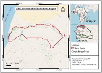
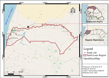
The Saint Louis region is bordered to the east by Matam region, to the west by the Atlantic Ocean, to the south by Louga region, and to the north by the Senegal River, which forms the border between the Islamic Republic of Mauritania and the Republic of Senegal 4 (Figure 1). It covers an area of 19,034 km², or about 10% of the national territory, and includes three administrative departments: Saint Louis, Podor, and Dagana. Located 270 km from Dakar, it has an estimated population of 1,204,863 in 2023, or a density of 63 inhabitants per km² 5.
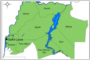
The Saint-Louis region has abundant water resources, divided into surface water and groundwater. Surface water consists mainly of the Senegal River, which crosses the region, its tributaries, Lake Guiers, and numerous backwaters and temporary pools. The lake is important because of its strategic role in supplying drinking water to the city of Dakar and for economic activities. The river and its tributaries are the most important source of water for agriculture. This rich potential is exploited by the Diama and Manantali dams. A number of lakes and ponds complete this hydrographic network. The most important are Lac de Guiers, the Yéti Yone-Ndiaël system, and the three backwaters (Figure 1).
With a length of 800 km and a drainage basin covering approximately 300,000 km², the Senegal River is the second largest river in West Africa after the Niger River 5. Its basin is shared by four countries (Guinea, Mali, Mauritania, and Senegal), representing between 7 and 14% of each country's national territory 5. The river originates in northern Guinea, crosses western Mali, and then forms the border between the Republic of Senegal and the Islamic Republic of Mauritania for the rest of its course.
The Senegal River is divided into three parts: the Upper Basin, the Valley, and the Delta 7. The Bafing and Bakoye, two rivers in Guinean territory, meet near the town of Bafoulabé in Mali to form the Senegal River. The hydrographic network is then completed by a few minor tributaries on the right bank, notably the Karakoro and the Kolombiné, and by the most important tributary on the left bank, the Falémé 7.
It covers an area of nearly 300 km²and contains some 600 million cubic meters of water when the water level is at 2 m IGN. Lac de Guiers (Figure 2) is Senegal's largest freshwater reserve. Sen'Eau's drinking water pumping and treatment plants in Ngnith and Keur Momar Sarr provide a significant portion of the drinking water needs of the city of Dakar and other cities along the pipeline.
Lac de Guiers enables the development of more than 30,000 hectares of irrigated land. The Taouey is a 17 km canal connecting Lac de Guiers to the Senegal River. In the past, Lac de Guiers was naturally fed by both the Senegal River and the lower Ferlo Valley according to a unique mechanism based on the water levels in the river, the lake, and the lower Ferlo Valley. The lake received water from the river during the rainy season in the north via the Taouey and in the south via the Ferlo, which ends locally in the Mboundoum valley. At Keur Momar Sarr, the lake curves and opens onto the Boundoum valley (lower Ferlo), which is shaped like an arc oriented west-northwest, east- southeast for its first few kilometers, then following a north-northeast, south-southwest axis between Diamet and Menguélé 8.
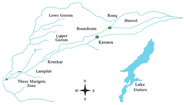
Approximately 25 km long between Ronkh and Boundoum Dam, it irrigates several thousand hectares and feeds the Kassak and Lampsar rivers, which continue on to the Saint-Louis drinking water reserve (Bango Reserve) 9. It rises in Ronkh, about 100 km from the mouth, and flows in a northeast-southwest direction. It meanders extensively before joining the river upstream of Tièng Island. Together with the Lampsar, it forms a waterway known as Gorom Lampsar, which is entirely dependent on the river for its supply 10.
It is fed by the Senegal River via structure G and is separated from the upper Gorom by the Boundoum dam. Given its dual functions of drainage and irrigation, the lower Gorom has been isolated from the upper Gorom by the Boundoum dam to serve as a collector of drainage water from the Boundoum perimeter 9.
This is the tributary that flows out of the Demba Diawar structure. It crosses the western part of the municipality of Ross-Béthio and feeds its downstream section. The Lampsar is actually an extension of the Kassak, currently fed from Diambar 10. It is fed by the upper Gorom, with which it forms the Gorom-Lampsar axis, which is the main waterway of the delta. The axis stretches for 95 km to Dakar Bango. It consists of three reaches separated by the Ross-Béthio and Ndiol structures. The Lampsar feeds the downstream Kassak and, together with the Djeuss and Ngalam, forms the Saint-Louis reservoir in its downstream section. This complex feeds the Trois Marigots when the Ndiaoudoune structure is opened 9.
It is an essential water source in the area, supplying the three backwaters and the Gandiol canal. It acts as an overflow for the Saint-Louis freshwater reserve via the Ndiawdoune structure. It is connected to the three backwaters that extend towards the Ndiaël depression 11. Together with the Lampsar and the Djeuss, it forms the Saint-Louis water reserve. The Ngalam is very wide in its downstream section at the confluence with the Lampsar and has a large capacity at this point. It acts as a storage basin for the reserve's water up to the Ndiaoudoune structure on the national road. This structure, equipped with cofferdams, is used to isolate the reserve and periodically renew the water. The Ngalam is connected to the Mbenguène and Khant depressions 9.
This term refers to a parallel series of interdune lakes, of which there were four until the end of the last century and probably many more in the past. They are fed by the Senegal River from the southwest via the Ngalam. The hydro-agricultural developments undertaken in the delta since the 1960s, the construction in 1986 of the Diama dam on the Senegal River and the Ndiawdoune dam on the Ngalam have caused a drastic drop in the water level of the three backwaters (Map 3).
For the past ten years or so, water has been flowing regularly and the backwaters are generally filled every year, to the point that they no longer dry up completely and allow vegetation to grow 8. These three backwaters are the Khant, the Ndjim, and the Ndiasséou. There was a fourth backwater, the Guélack, which dried up in the 1950s. Its fossil valley, now a series of basins, is still clearly visible in the landscape. These backwaters are roughly parallel interdune depressions, each varying in size between 480 and 800 ha. The depressions are separated by unaltered red dunes from the Ogolien period 9. In the early 1950s, the Ndiaël and the three backwaters were one of the most important wetland complexes in the Senegal River delta. Development and road infrastructure have led to the drying up of the Ndiaël, a Ramsar site, and to irregular water inflows in the three backwaters. These two sites are the focus of the greatest attention. The reflooding of Ndiaël has become a reality after more than 30 years of waiting, and the current management plan aims to provide solutions to improve the functioning of the three backwaters and preserve its great ecological value in the long term 9.
The Yéty Yone-Ndiaël- three backwaters hydrographic axis, approximately 80 km long, is located in the Diéri part of the Senegal River delta, which it runs through from north to south. The Yéty Yone-Ndiaël- three backwaters system is located west of Lake Guiers. It connects to the northwest of Lac de Guiers, through which it feeds into the Ndiaël 11.
It is fed by the Gorom Lampsar complex. It is used as a water supply and drains water from the Lampsar. The lower part of the Djeuss constitutes the water reserve for Saint Louis 11. It is used as a water supply, but also as a drain. As a result, its two upper and lower reaches are separated by the Keur Samba Sow structure. The downstream Djeuss, which flows into the Lampsar at Mboubène, together with the latter, forms the Saint-Louis reserve. The upstream Djeuss is also fed from the Senegal River by the H structure. This allows the water to be used for irrigation of village and private irrigated areas 9.
Located west of Lac de Guiers, the Yéti Yone is a 28-kilometer-long waterway. It connects to the northwest of Lac de Guiers, through which it feeds the Ndiaël watershed. It is bordered to the southeast by the Ross-Béthio dune massif 11.
This is a wetland of international importance classified as a Ramsar site (1977). The systematic drying up of the reserve and the gradual loss of its ecological and hydrological functions led to its inclusion in the Montreux register (1990). Its role in biodiversity conservation and resource optimization necessitated its revitalization as part of the Project for the Restoration of the Ecological and Economic Functions of Lac de Guiers (PREFELAG) implemented by OLAC between 2014 and 2019 8.
This is a 30 km long tributary of the river. It flows parallel to the Gorom in a north-south-west direction. It originates in the Gorom at the Diambar basin and its other end is linked to the Lampsar 11. The Kassak is the remnant of an ancient branch, which origin is believed to be near Thiagar and which continues through the Lampsar. It was captured by the Gorom at Dianbar and thus contributes to the Gorom-Lampsar hydraulic system, which it bypasses 12.
From a climatic point of view, the delta is part of the Sahelian region, which is characterized by irregularity and spatial and temporal variability, strongly influenced by rainfall. It is a region subject to the influence of maritime trade winds blowing from the Azores high, which gives it a very mild climate compared to the rest of the country 13.
In the Senegal River Delta, temperatures generally increase from south to north and from the coast to the interior of the basin. Annual averages range from 20 to 40°C, with extremes varying between 12°C (November-February) and 45°C (May-June). The lowest temperatures are observed in January-February 14. Temperatures also vary over time with the seasons, particularly with rainfall, which lowers temperatures, and spatially with proximity to or distance from the sea 4.
Soils are effectively the result of a set of hydro-climatic phenomena that interact with each other. Marine and fluvial influences play an important role in their formation 15. Two types of soil are generally found in the river delta 16:
The dune sands originate from the Quaternary geological formation and are completely isolated and spread over the dunes, particularly on Lac de Guiers. Although sandy, the dune soils also include brown nodular and reddish- brown soils that are suitable for certain agricultural practices such as food crops 16.
The alluvial deposits located in the dune areas result from regular flooding of the river and are distinguished by a clay or silt-clay crust that is regularly flooded. During periods of low water, the intrusion of seawater with groundwater causes saline deposits on the alluvial deposits, disrupting the balance of the delta environment. These soils have a salinity of at least 0.2% sodium salt and occupy most of the delta 16.
The economy around the Senegal River Delta is based mainly on agriculture. In fact, it was seasonal rain-fed agriculture, which, due to climatic hazards, found itself in a very difficult situation. However, irrigation has made it possible to overcome the agricultural constraints in this area 17. Irrigated agriculture has continued to develop since the construction of dams and the establishment of structures to supervise and monitor developments such as the SAED (Société Nationale d'Aménagement et d'Exploitation des Terres du Delta du Fleuve Sénégal) in the delta area. Lac de Guiers and the various river tributaries make this area a pioneer in irrigated agriculture, in addition to the evolution of the area's hydrological context thanks to the major developments installed since 1985 18. Indeed, following the construction of dams, the delta area has seen an explosion of private initiatives in the context of village irrigation perimeters, which has led to a decline in rural exodus 18. In addition, the delta region contributes significantly to national cereal production, particularly rice, as well as ensuring total sugar cane production through the CSS (Compagnie Sucrière Sénégalaise). It is also an area of onion and industrial tomato production, with the Société de Conserve Alimentaire du Sénégal for tomatoes 19. This activity contributes to food security and, consequently, improves the country's economic performance. Also known as the "sylvo-pastoral zone," livestock farming is the second most common activity in the delta region, regardless of ethnicity, with large herds of cattle 20.
Like agriculture, the livestock sector is one of the main pillars of the structural transformation of the Senegalese economy 19. It is an activity that contributes to food security and, consequently, to improving the country's economic performance. Also known as the "sylvo-pastoral zone," livestock farming is the second most common activity in the delta region, regardless of ethnicity, with large herds of livestock 20. Extensive and transhumant livestock farming by the Fulani is a traditional practice based on the use of natural pastures. This method of livestock farming allows herders to adapt to seasonal variations and the availability of fodder throughout the year 21. On the other hand, livestock farming is intensive, i.e., a sedentary village activity among the Wolof and Moors with small ruminants 22.
Fishing contributes to the dynamism of the country's local economy. It is a sector that contributes significantly to the food supply of local populations and also to the country's gross domestic product 19.
Inland Inland fishing has long been a highly developed activity in the Senegal Delta 18. It was practiced using traditional methods, with immediate consumption by local populations, and was considered a means of subsistence for riverside dwellers 20. Today, in addition to inland fishing, aquaculture is also being developed in the area with the implementation of development projects such as the Multinational Program to Strengthen Resilience to Food and Nutritional Insecurity in the Sahel (P2RS). These are often community or private farms, supported by the National Aquaculture Agency (ANA). However, this activity, like livestock farming, also faces obstacles such as the decline of aquatic plants such as typha and ceratophyllum, which invade water bodies 23, reducing access to water for fishermen 1. Between 2013 and 2014, there was a 15% decline in weight and an 11.47% decline in value in fishing around Lac de Guiers. This decline is the result of climate change and the proliferation of cattail in the water bodies 17.
2.2. In-situ Measurements and SamplingIn-situ measurement strategies for physical parameters were carried out at all sampling points, followed by sample collection, packaging, transport, and storage in the laboratory prior to physical and chemical analysis.
To carry out this study, two campaigns of in-situ measurements of temperature (°C), pH, and electrical conductivity (µS/cm), as well as sampling, were carried out on December 22, 2023 (just after the rainy season) at the sites of Rawette, Ronkh, and Ross Béthio, followed by measurements on January 9, 2025, at Mboubène bridge, Kassak, and Mboundoum sites. For the first campaign, six (03) samples were taken, two (02) per site, while for the second campaign, three (03) samples were taken, one (01) per site (Figure 4). The nine samples were packaged in 500 mL polyethylene bottles and transported in a cooler to the CERES LOCUSTOX laboratory in Dakar for physical and chemical analysis (turbidity, major ions, and heavy metals).
Physical parameters such as temperature (°C), pH, and electrical conductivity (µS/cm) were measured at all study sites (Figure 4) using a ROWA pH meter and conductivity meter.
Figure 1 illustrates the spatial variation in temperature from upstream, i.e., measurements taken during the first campaign in December 2023, to downstream, corresponding to measurements taken during the second campaign in May 2025. These results show that the lowest temperature (19.9°C) recorded at Rawette was in the winter of 2023, while the highest (27.2°C) was measured at Kassak in the summer of 2025.
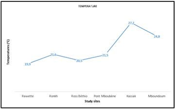
Figure 6 shows the variation in pH at the six study sites. These values were measured in December 2023 for the first three sites and in May 2025 for the last three sites. In the figure, the highest pH values (8.2 to 8.6) were recorded during the first measurements taken in December 2023, a period corresponding to the immediate end of the rainy season and the beginning of winter. In contrast, the minimum pH values (6.89 to 6.74) were recorded in the summer of 2025 at Mboubène bridge, Kassak, and Mboundoum sites. However, the maximum value of 8.6 measured at the Rawette site complies with the SEQ 1 –EAU 2003 standard (Figure 6).
These maximum pH values recorded at the end of the rainy season can be explained by the presence of chemical waste from gold mining, agro-industrial activities, and boat engine repairers on the river's tributaries where these water purification and treatment units (UPTs) are located.
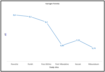
Figure 3 shows the evolution of in-situ results for electrical conductivity. Measurements taken during the first campaign in December 2023 show a downward trend at Rawette, Ronkh, and Ross-Béthio sites, with electrical conductivities ranging from 78 to 70 µS/cm. However, a minimum value of 61 µS/cm was recorded at the Kassak site during the second campaign in May 2025. Nevertheless, these electrical conductivity results from in-situ measurements all comply with the SEQ 1 –EAU 2003 standard (Figure 7).
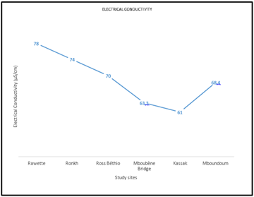
Figure 8 shows the variation in turbidity over the two measurement campaigns in December 2023 and May 2025. For the first campaign, the turbidity results show a value of 127 NTU, which complies with the SEQ 1 –EAU 2003 standard (150 NTU) for Ross Béthio site, followed by high values of 240 and 320 NTU respectively for the Rawette and Ronkh sites (Figure 5). For the second campaign, the turbidity values comply with the above standard (Mboubène 27.74 NTU and Mboundoum 70.28 NTU), except for Kassak site with a value of 164 NTU (Figure 8).
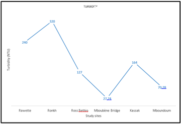
The high turbidity values can be explained by the fact that the measurements were taken immediately after the end of the rainy season. This period corresponds to the influx of runoff water loaded with organic and mineral matter from the river, on the one hand. On the other hand, there are gold panning sites located upstream of the stations discharging their waste into the river, as well as agro-industrial activities in the area.
On the other hand, the low values observed during the second campaign (in May) can be explained simply by the low levels of organic and mineral elements and the slowdown.
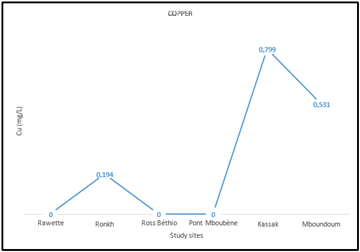
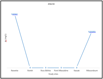
3.3. Heavy Metals (Pb, Zn, Cu, Cd, Ar)For heavy metals, copper (Cu) and arsenic (Ar) show minimum concentrations of 0 and maximum concentrations of 0.194 to 0.0162 mg/L, respectively, following a spatio-temporal variation that complies with the values established by the standard.
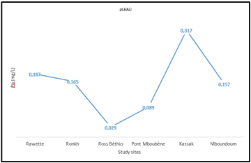
Lead (Pb) was detected in all samples during both campaigns, with concentrations ranging from 0.029 to 0.317 mg/L, exceeding the threshold values established by the standard.
Only cadmium (Cd) and zinc (Zn) were completely absent in both campaigns.
This work made it possible to evaluate heavy metals in raw water flowing in the effluents of the Senegal River Delta (the source of water supply for the population) and to determine their origins.
The results showed the presence of heavy metals such as lead, arsenic, and copper in both campaigns corresponding to the two seasons, namely the rainy season and the dry season. However, cadmium and zinc were completely absent at all study sites and during both periods.
These metals probably originate from agro-industrial activities upstream of the study sites, illegal gold panning, motor pump repairs, and water runoff during the rainy season. This contamination could be prevented by treating waste in accordance with regulations (compliance with Senegalese waste standards). However, the presence of these metals has made it possible to identify the waterborne diseases that could result for users. After analysis, waterborne diseases such as bilharzia have been noted in humans and liver fluke in animals, even though the OMVS has begun installing water purification and treatment units to protect the health of users.
| [1] | Saliou Kamara, "Hydraulic developments and management of a largely anthropized hydrosystem: the Senegal River delta" 2013. | ||
| In article | |||
| [2] | Doods and King, "Relationship between trihalomethane compounds and congenital malformations" 2001. | ||
| In article | |||
| [3] | Nieuwenhuijsen, Mellah-J Toledano, Paul Elliot, "Relationship between trihalomethane compounds and congenital malformations" 2001. | ||
| In article | |||
| [4] | ANSD, "Regional economic and social situation” | ||
| In article | |||
| [5] | ANSD, "www.ansd.sn/taxonomy/term/8," 2023. [Online]. Available: https:// www.ansd.sn/ taxonomy/ term/8? page=1. [Accessed June 18, 2025]. | ||
| In article | |||
| [6] | OMVS, "State of the environment in the Senegal River basin" 2011. | ||
| In article | |||
| [7] | Mohamed Talla Cissé, Soussou Sambou, Yaya Diémé,"Effect of the Manantali dam on changes in the hydrological regime of the Senegal River in the upper basin: a statistical approach" Science and Global Change, vol. 20, no. 111, pp. 104-111, 2009. | ||
| In article | View Article | ||
| [8] | (OLAC), "hydrographic-network/lake-de-guiers" 2021. [Online]. Available: hydrographic- network/lake-de-guiers. [Accessed January 27, 2025]. | ||
| In article | |||
| [9] | Patrick Triplet, Ndèye Astou Sané, Rokhaya Wade,"Management plan for the three backwaters" 2019-2023. | ||
| In article | |||
| [10] | Abdoulaye Faye, "Water and physical environment in the Gorom-Lampsar basin" 1989-1990. | ||
| In article | |||
| [11] | Saer Gaye, "Modeling of flow propagation in the delta's hydraulic axes: application of the SIC model validated by the HEC-RAS model" 2015. | ||
| In article | |||
| [12] | Société Grenobloise d'Etudes et d'Applications Hydrauliques, "Hydrology of the Senegal River delta (left bank of the river)," 1964. | ||
| In article | |||
| [13] | Papa Malick Ndiaye, "Evaluation, calibration, and analysis of current and future trends in reference evapotranspiration in the Senegal River basin," 2021. | ||
| In article | View Article | ||
| [14] | Adrien Coly, "Towards integrated management of the Senegal coastline and river basin," 2002. | ||
| In article | |||
| [15] | Boubacar Cissé, "Drainage water from irrigated areas in the Senegal River delta: drainage systems and water quality," 2011. | ||
| In article | |||
| [16] | Mor Talla Sall, "Study of irrigation/drainage practices in the irrigated perimeter of the Senegalese sugar company: proposal for improvement," 2005. | ||
| In article | |||
| [17] | Mame Ramatoulaye Faye, "Contribution to improving access to water for irrigated agriculture in the face of the proliferation of aquatic plants, including Typha australis, in the Senegal River Delta: the case of the CSS” | ||
| In article | |||
| [18] | Awa Niang, "Development of Lake Guiers from 1824 to the advent of the great dams on the Senegal River: a geographical perspective. Climate and development," 1999. | ||
| In article | |||
| [19] | ANSD, "Regional economic and social situation," 2019. | ||
| In article | |||
| [20] | Penda Diop, "Towards a participatory multi-use water resource management strategy in the Senegal River Delta: decision-making processes and regulatory tools around Lake Guiers," 2017. | ||
| In article | |||
| [21] | SCOPELA, "Standing vegetation report," 2014. | ||
| In article | |||
| [22] | Souleymane Gueye, "Study of the evolution of the Lake Guiers region," 1999. | ||
| In article | |||
| [23] | PGIRE 2, "Characterization of inland fishing and aquaculture in the department of Dagana and the ponds of the departments of Matam and Kanel in the Republic of Senegal," 2016. | ||
| In article | |||
Published with license by Science and Education Publishing, Copyright © 2025 Ahmed Dame MBOUP, Alassane THIAM and Abib NDIAYE
![]() This work is licensed under a Creative Commons Attribution 4.0 International License. To view a copy of this license, visit
http://creativecommons.org/licenses/by/4.0/
This work is licensed under a Creative Commons Attribution 4.0 International License. To view a copy of this license, visit
http://creativecommons.org/licenses/by/4.0/
| [1] | Saliou Kamara, "Hydraulic developments and management of a largely anthropized hydrosystem: the Senegal River delta" 2013. | ||
| In article | |||
| [2] | Doods and King, "Relationship between trihalomethane compounds and congenital malformations" 2001. | ||
| In article | |||
| [3] | Nieuwenhuijsen, Mellah-J Toledano, Paul Elliot, "Relationship between trihalomethane compounds and congenital malformations" 2001. | ||
| In article | |||
| [4] | ANSD, "Regional economic and social situation” | ||
| In article | |||
| [5] | ANSD, "www.ansd.sn/taxonomy/term/8," 2023. [Online]. Available: https:// www.ansd.sn/ taxonomy/ term/8? page=1. [Accessed June 18, 2025]. | ||
| In article | |||
| [6] | OMVS, "State of the environment in the Senegal River basin" 2011. | ||
| In article | |||
| [7] | Mohamed Talla Cissé, Soussou Sambou, Yaya Diémé,"Effect of the Manantali dam on changes in the hydrological regime of the Senegal River in the upper basin: a statistical approach" Science and Global Change, vol. 20, no. 111, pp. 104-111, 2009. | ||
| In article | View Article | ||
| [8] | (OLAC), "hydrographic-network/lake-de-guiers" 2021. [Online]. Available: hydrographic- network/lake-de-guiers. [Accessed January 27, 2025]. | ||
| In article | |||
| [9] | Patrick Triplet, Ndèye Astou Sané, Rokhaya Wade,"Management plan for the three backwaters" 2019-2023. | ||
| In article | |||
| [10] | Abdoulaye Faye, "Water and physical environment in the Gorom-Lampsar basin" 1989-1990. | ||
| In article | |||
| [11] | Saer Gaye, "Modeling of flow propagation in the delta's hydraulic axes: application of the SIC model validated by the HEC-RAS model" 2015. | ||
| In article | |||
| [12] | Société Grenobloise d'Etudes et d'Applications Hydrauliques, "Hydrology of the Senegal River delta (left bank of the river)," 1964. | ||
| In article | |||
| [13] | Papa Malick Ndiaye, "Evaluation, calibration, and analysis of current and future trends in reference evapotranspiration in the Senegal River basin," 2021. | ||
| In article | View Article | ||
| [14] | Adrien Coly, "Towards integrated management of the Senegal coastline and river basin," 2002. | ||
| In article | |||
| [15] | Boubacar Cissé, "Drainage water from irrigated areas in the Senegal River delta: drainage systems and water quality," 2011. | ||
| In article | |||
| [16] | Mor Talla Sall, "Study of irrigation/drainage practices in the irrigated perimeter of the Senegalese sugar company: proposal for improvement," 2005. | ||
| In article | |||
| [17] | Mame Ramatoulaye Faye, "Contribution to improving access to water for irrigated agriculture in the face of the proliferation of aquatic plants, including Typha australis, in the Senegal River Delta: the case of the CSS” | ||
| In article | |||
| [18] | Awa Niang, "Development of Lake Guiers from 1824 to the advent of the great dams on the Senegal River: a geographical perspective. Climate and development," 1999. | ||
| In article | |||
| [19] | ANSD, "Regional economic and social situation," 2019. | ||
| In article | |||
| [20] | Penda Diop, "Towards a participatory multi-use water resource management strategy in the Senegal River Delta: decision-making processes and regulatory tools around Lake Guiers," 2017. | ||
| In article | |||
| [21] | SCOPELA, "Standing vegetation report," 2014. | ||
| In article | |||
| [22] | Souleymane Gueye, "Study of the evolution of the Lake Guiers region," 1999. | ||
| In article | |||
| [23] | PGIRE 2, "Characterization of inland fishing and aquaculture in the department of Dagana and the ponds of the departments of Matam and Kanel in the Republic of Senegal," 2016. | ||
| In article | |||


