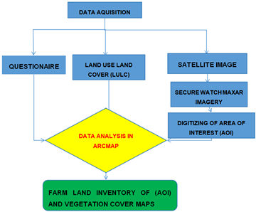
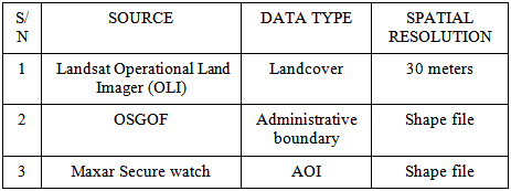
A rigorous process for acquiring, compiling, and managing data about agricultural properties within a certain geographical or legal jurisdiction is known as a farmland inventory. It requires finding and recording information about each farmland parcel, such as its location, size, owner, and current land use. Crop fields are the basic organizational unit in agricultural production and the ability to record the size, contours and geographic distribution of agricultural fields is an important component of rural landscapes by delineating field boundaries and creating a database through inventory. This work's general approach is to use agricultural field maps and questionnaires to enhance the FCT's farmland inventory. Therefore, we place a focus on the segmentation of fine-resolution satellite images from Maxar Secure Watch, which offers access to imagery base maps and a number of Open Geospatial Consortium (OGC) services (Web Mapping Service WMS, Tile Mapping Service TMS, Web Feature Service WFS). The farmland was digitized inside the region of interest that was constructed using the high-resolution images from Maxar SecureWatch that allows us to run Mapflow Al-mapping over Secure Watch imagery. In order to identify changes that have happened throughout time in the research area, land use and land cover (LULC) data from three (3) epochs were used. The results show very good inventory and change detection in LULC which if considered will be of great advantage in agricultural production (precise and thorough datasets) for various agricultural planning, policy-making, and land management reasons.
Since the 1970s, one of the most pressing issues confronting the world today is food security; more food has been produced than the assumed maximum amount needed to feed the world's expanding population. This is confirmed by the 3.2 billion-population increases that occurred between 1970 and 2010, of which Nigeria contributes for 2.71% 1, 2, 3. The amount of cultivated land is limited, and most of it has been irreversibly degraded, rendering it unsuitable for agricultural production 4, 5, 6. Agriculture development and sustainability forms the basis of the world's food continuity of supply. However, soil conditions, water availability, weather extremes, climate change, lack of knowledge and access to reliable information, can represent costly challenges both to farmers and the overall food security of populations 7, 8.
Identifying field boundaries can provide important information for increasing food production and security in agricultural systems across the globe. This is because knowing field boundaries is fundamental for many analytical applications, including generating crop statistics, quantifying the extent and drivers of yield gaps, and identifying potential solutions to increase production 9, 10, 11, 12. It is particularly important to obtain such information in smallholder farming systems, where yield gaps are large 13 and which produce approximately 56% of global agricultural production 14, 15. Remote sensing can offer a way to efficiently and cost-effectively map field boundaries across large spatial and temporal scales. Current methods advancing field boundary mapping using satellite data have primarily focused on large-scale farming systems, such as those in the Americas, Europe, and Australia 16, 17, 18. To date, little remote sensing work has been undertaken to map field boundaries in smallholder systems, such as those found across Asia and Africa, where very small field sizes (<0.64 ha) are prevalent 19.
Advanced nations have already embraced the use of GIS and remotely sensed data to determine the amount of land covered, the size of farmlands, soil types, suitable crops for production and to also keep an eye on crop health and vegetation development, to measure yields and harvest times Babamaaji et, al 2022. As a result, the distribution of their food products from harvest to markets 20. This system can be implemented in Nigeria to help further ensure crop health, food security, supply, and distribution throughout the country 21; it will support the sustainable agriculture at the center of the 2030 agenda and the first crucial steps toward achieving the SDG 2 and 15 which is aimed towards ending hunger and sustaining life on land 22.
Farmers in Nigeria and many other developing nations continue to struggle to make their practices more profitable and to produce crops that are both efficient and effective 23. Farmers suffer considerable losses as a result of environmental issues such as land degradation, drought, pest’s infestation, crop diseases, and other climate-related impacts 24, but adopting GIS management tools that incorporate crop field inventory, mapping, and scouting can reduce these losses 25.
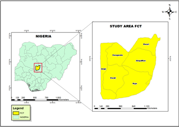
Study Area
Abuja is the capital city of Nigeria located in the middle of the country. It falls within latitude 7° 25’ N and 9° 20’ North and longitude 5°45’ and 7° 39’ East respectively. The Federal Capital Territory has a land area of 8,000 square kilometers, two and halftimes the size of Lagos, the former capital of Nigeria 26. FCT is bounded on the north by Kaduna State, on the west by Niger State, on the east and south-east by Nasarawa State, and on the south-west by Kogi State. Abuja is dotted with hills, highlands and other distinguishing features that make it a delight to behold 27, 28. Abuja has been characterized as savannah grassland of the north and the middle belt with the richness of the tropical rain forests of the south. This marriage of nature has ensured that Nigeria’s capital is endowed with fertile land for agriculture and at the same time a yearly climate that is neither too hot nor too cold 29, 30.
General Work Flow
The general strategy of this work is to leverage agricultural field maps to improve farmland inventory in FCT. Therefore, we emphasize fine-resolution satellite image segmentation from Maxar Secure watch, which provides access to imagery base maps and various OGC services (WMS, TMS, WFS). Plugin in QGIS was integrated smoothly. This high-resolution imagery from Maxar securewatch enables us to run the mapflow Al-mapping over secure watch imagery and area of interest was created within which the farmland was digitized. Land use land cover (LULC) over a period of three (3) epochs was used to determine changes that occurred over a period of time within the study area.
Database
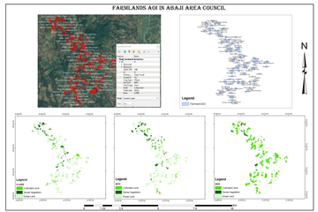
Detailed information on farmland (AOI) features, such as location, size, and Farmers name were documented (as shown in figures below) and proved to be collected using remote sensing and GIS techniques in agreement with 31, 32. This information can be used to discover spatial patterns and linkages, assess land suitability for different crops, and track changes in land use over time. Farmland inventory provides a firm platform for assessing agricultural production, land degradation, climate change impacts, and devising effective solutions for sustainable land management by utilizing scientific approaches as stated by 31, 32.
Land Use Land Cover (LULC)
Abuja, the capital city of Nigeria, has undergone significant changes in land use and land cover over the past few decades 33. The city was established in 1976, and since then, there has been a steady increase in its population, leading to the expansion of the city's boundaries and changes in its land use and land cover 34. Currently, residential areas, commercial areas, and public infrastructure such as roads, airports, and public buildings dominate Abuja’s land use 35. There are also significant areas of undeveloped land, which are mainly used for agriculture and forestry. In terms of land cover, Abuja has experienced significant changes. The city's vegetation cover has been reduced due to the expansion of built-up areas and the clearing of land for agriculture and other land uses. The city's water bodies, such as rivers and streams, have also been affected by human activities such as pollution and encroachment 36.
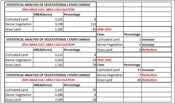
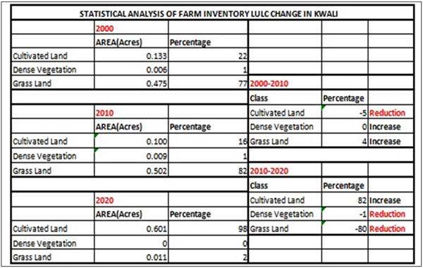
The LULC changes in the Abaji area between 2000 and 2020 indicate a significant increase in cultivation, with little to no grassland remaining in the area as shown in Figure 3. The NDVI analysis suggests that there has been an increase in vegetation density, especially in the 2010 and 2020 time periods, which may be attributed to the expansion of cultivated lands. Overall, the changes in LULC over time (Table 2) may have implications for local ecosystems, agricultural practices, and water resource management in the area as shown in the table above.
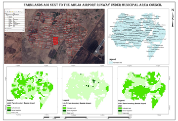
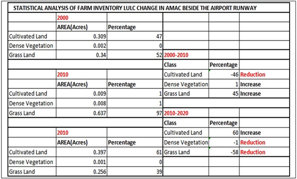
The LULC changes in the AOI beside the airport runway between 2000 and 2020 suggest a cycle of cultivation and grassland presence. In 2000, the area had a mix of grassland and cultivated land, which decreased significantly by 2010. However, in 2020 there was an increase in cultivation that surpassed the 2000 levels. Despite the increase in cultivation, grassland was still visible in the area. These changes may have implications for the ecology of the region, including soil health, biodiversity, and ecosystem services.
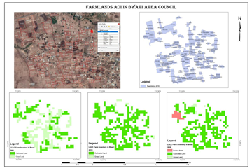
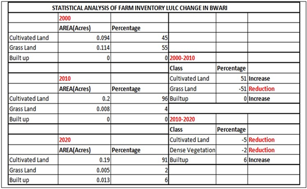
The changes in the LULC in the AOI in Bwari suggest a significant shift in land use over the last two decades. In 2000, the area was a mix of grasslands and cultivated land, with the latter occupying a relatively smaller area compared to the former. By 2010, the cultivated land had expanded significantly, leading to a decline in grasslands in most parts of the AOI. In 2020, there was a further increase in cultivated land, with a small portion of the area showing signs of built-up areas. These changes in LULC could have important implications for the environment, including soil degradation, loss of biodiversity, and changes in local weather patterns.
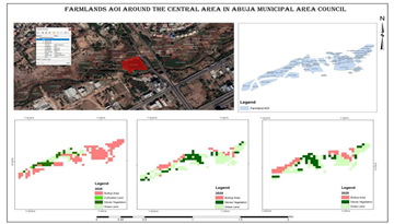
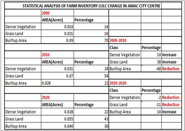
Based on the information provided by the Sattellite Imagery and a field validation, the LULC changes in the AOI in AMAC central over the years suggest a significant decrease in built-up areas between 2000 and 2020, with a increase in the proportion of grasslands with a few dense vegetation in sight. This shift may have implications for land use management, and environmental sustainability.
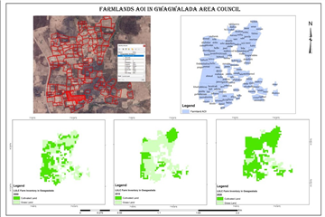
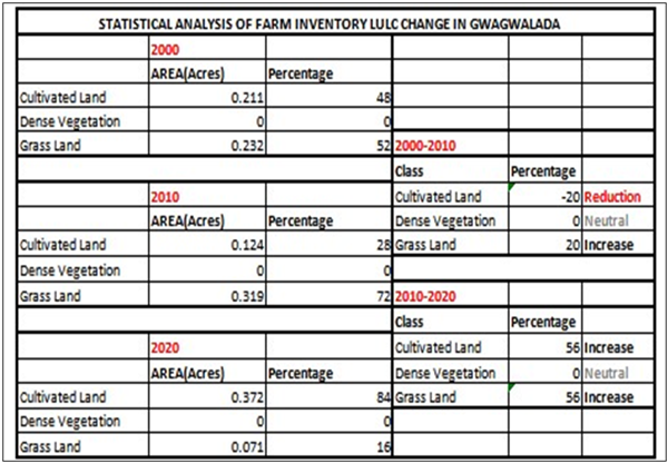
The land use and land cover in the AOI in Gwagwalada has undergone some changes over time. In the year 2000, the area was predominantly cultivated land with some grassland mixed in. In 2010, there was a decrease in cultivated land, which led to the grasslands becoming more predominant. However, in 2020, there was an out sprawl of cultivated land, which has become the most predominant feature. Nonetheless, there are still some grasslands in the area, although they may be fewer in number than before.
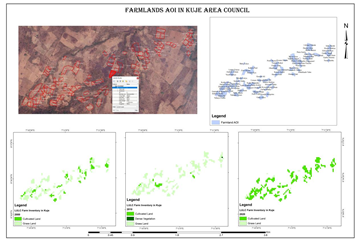
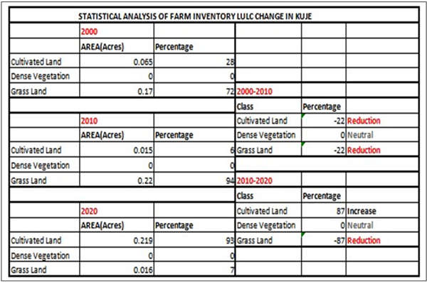
In 2000, the AOI shows a mixture of both grasslands and cultivated land, but the grasslands were more predominantly by 2010, there was a decrease in the cultivated land, leading to grasslands being more predominant, although the mix of both land covers remained. In 2020, there was an outgrowth of cultivated land as the most predominant feature, although there were still some areas with grasslands.
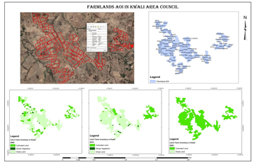
In 2000, the area was mainly covered with grasslands with some cultivated lands and dense vegetation. In 2010, the mix of cultivated land and grassland remained, but there was a slight increase in the cultivated land. Finally, in 2020, the cultivated land became the most predominant feature, with only a few grasslands remaining.
In conclusion, the use of spatial technology in conducting a farmland inventory was an effective method in FCT Abuja Nigeria. The study provided valuable information on the location, size, and productivity of each farmland. The development of a database for farmlands was a significant achievement of the study, which can be used for decision-making purposes in the agricultural sector. However, the challenges facing farmland owners need to be addressed to promote sustainable agriculture in the region and government has to monitor and regulate the use of these soils to prevent environmental degradation and ensure its continued productivity
| [1] | Alexandratos, N., & Bruinsma, J. (2012). World agriculture towards 2030/2050: the 2012 revision. | ||
| In article | |||
| [2] | Bergaglio, M. (2017). The contemporary illusion: population growth and sustainability. Environment, Development and Sustainability, 19, 2023-2038. | ||
| In article | View Article | ||
| [3] | Babamaaji, R.A., Shaba, H.A., Adepoju, M.O., Yusuf, M.J., Jantiku, J., Eshiet, R.C., Amanabo, U.H., Akinola, O., Haruna, M., Ibrahim, H. and Bako, H., 2022. Evaluation of Links between Maize Farmlands and Infrastructures in the North Central Nigeria Using Geospatial Techniques. European Journal of Agriculture and Food Sciences, 4(4), pp.1-5. | ||
| In article | View Article | ||
| [4] | Verheye. (2008). Crops: Yam. Retrieved from http:// www. iita.org/yam. | ||
| In article | |||
| [5] | Kuang, B., Lu, X., Zhou, M. and Chen, D., 2020. Provincial cultivated land use efficiency in China: Empirical analysis based on the SBM-DEA model with carbon emissions considered. Technological Forecasting and Social Change, 151, p.119874. | ||
| In article | View Article | ||
| [6] | Tercan, E. and Dereli, M.A., 2020. Development of a land suitability model for citrus cultivation using GIS and multi-criteria assessment techniques in Antalya province of Turkey. Ecological Indicators, 117, p.106549. | ||
| In article | View Article | ||
| [7] | Shahid, A., Almogren, A., Javaid, N., Al-Zahrani, F.A., Zuair, M. and Alam, M., 2020. Blockchain-based agri-food supply chain: A complete solution. Ieee Access, 8, pp.69230-69243. | ||
| In article | View Article | ||
| [8] | Brunori, G., Branca, G., Cembalo, L., D’Haese, M. and Dries, L., 2020. Agricultural and Food Economics: the challenge of sustainability. Agricultural and Food Economics, 8(1), pp.1-2. | ||
| In article | View Article PubMed | ||
| [9] | Haworth, B.T.; Biggs, E.; Duncan, J.; Wales, N.; Boruff, B.; Bruce, E. 2018. Geographic Information and Communication Technologies for Supporting Smallholder Agriculture and Climate Resilience. Climate, 6, 97. | ||
| In article | View Article | ||
| [10] | Jain, M.; Singh, B.; Srivastava, A.A.K.; Malik, R.K.; McDonald, A.J.; Lobell, D.B. 2017. Using Satellite Data to Identify the Causes of and Potential Solutions for Yield Gaps in India’s Wheat Belt. Environmental Research Letter. 12, 094011. | ||
| In article | View Article | ||
| [11] | Neumann, K.; Verburg, P.H.; Stehfest, E.; Müller, C. 2010. The Yield Gap of Global Grain Production: A Spatial Analysis. Agricultural System. 103, 316–326. | ||
| In article | View Article | ||
| [12] | Wagner, M.P.; Oppelt, N. 2020. Extracting Agricultural Fields from Remote Sensing Imagery Using Graph-Based Growing Contours. Remote Sensing. 12, 1205. | ||
| In article | View Article | ||
| [13] | Mueller, N.D.; Gerber, J.S.; Johnston, M.; Ray, D.K.; Ramankutty, N.; Foley, J.A. 2012. Closing Yield Gaps through Nutrient and Water Management. Nature. 490, 254–257. | ||
| In article | View Article PubMed | ||
| [14] | Samberg, L.H.; Gerber, J.S.; Ramankutty, N.; Herrero, M.; West, P.C.2016. Subnational Distribution of Average Farm Size and Smallholder Contributions to Global Food Production. Environmental Research Letter. 11, 124010. | ||
| In article | View Article | ||
| [15] | Sylvester, G. 2015. Success Stories on Information and Communication Technologies for Agriculture and Rural Development. RAP Public. 2, 108. | ||
| In article | |||
| [16] | Garcia-Pedrero, A.; Lillo-Saavedra, M.; Rodriguez-Esparragon, D.; Gonzalo-Martin, C. 2019. Deep Learning for Automatic Outlining Agricultural Parcels: Exploiting the Land Parcel Identification System. IEEE Access. 7, 158223–158236. | ||
| In article | View Article | ||
| [17] | Marvaniya, S.; Devi, U.; Hazra, J.; Mujumdar, S.; Gupta, N. 2021. Small, Sparse, but Substantial: Techniques for Segmenting Small Agricultural Fields Using Sparse Ground Data. International Journal of Remote Sensing. 42, 1512–1534. | ||
| In article | View Article | ||
| [18] | Masoud, K.M.; Persello, C.; Tolpekin, V.A. 2020. Delineation of Agricultural Field Boundaries from Sentinel-2 Images Using a Novel Super-Resolution Contour Detector Based on Fully Convolutional Networks. Remote Sensing. 12, 59. | ||
| In article | View Article | ||
| [19] | Lesiv, M.; Laso Bayas, J.C.; See, L.; Duerauer, M.; Dahlia, D.; Durando, N.; Hazarika, R.; Kumar Sahariah, P.; Vakolyuk, M.; Blyshchyk, V. 2019. Estimating the Global Distribution of Field Size Using Crowdsourcing. Global Change Biology. 25, 174–186. | ||
| In article | View Article PubMed | ||
| [20] | Newlands, N.K., 2018. Model-based forecasting of agricultural crop disease risk at the regional scale, integrating airborne inoculum, environmental, and satellite-based monitoring data. Frontiers in Environmental Science, 6, p.63. | ||
| In article | View Article | ||
| [21] | Balehegn, M., Duncan, A., Tolera, A., Ayantunde, A. A., Issa, S., Karimou, M., ... & Adesogan, A. T. (2020). Improving adoption of technologies and interventions for increasing supply of quality livestock feed in low-and middle-income countries. Global food security, 26, 100372. | ||
| In article | View Article PubMed | ||
| [22] | FAO. (2020). Nigeria at a glance. Retrieved from http:// www.fao.org/nigeria/fao-in-nigeria/nigeria-at-aglance/en/Ghosh, M., & Ghosh, S. K. (2013). Rural planning models using GIS and remote sensing: A review. Retrieved from http:// www. gisdevelopment.net/application/lis/rural/mi0599.htm. | ||
| In article | |||
| [23] | Minot, N., 1986. Contract farming and its effect on small farmers in less developed countries (No. 1096-2016-88476). | ||
| In article | |||
| [24] | Altieri, M.A. and Koohafkan, P., 2008. Enduring farms: climate change, small holders and traditional farming communities (Vol. 6). Penang: Third World Network (TWN). | ||
| In article | |||
| [25] | Saiz-Rubio, V. and Rovira-Más, F., 2020. From smart farming towards agriculture 5.0: A review on crop data management. Agronomy, 10(2), p.207. | ||
| In article | View Article | ||
| [26] | Lateef, A.A., Smart, O., Toba, S.A. and Olatunde, P.A., 2020. Medicinal plants used in ethnoveterinary practices in the Federal Capital Territory, North-Central Nigeria. Journal of Medicinal Plants Research, 14(8), pp.377-388. | ||
| In article | View Article | ||
| [27] | Omali, T.U., 2020. Ecological evaluation of urban heat island impacts in Abuja Municipal Area of FCT Abuja, Nigeria. World Academics Journal of Engineering Sciences, 7(1), pp.66-72. | ||
| In article | |||
| [28] | Musa, P.E., Oguche, C.J. and Oyekwulu, M.C., 2020. Evaluating the Environmental Impacts of Hawking along the Outer Northern Expressway (ONEX) in Federal Capital Territory Abuja, North Central, Nigeria. Journal of Environmental Science and Public Health, 4(2), pp.83-95. | ||
| In article | |||
| [29] | Aderoju, O.M., Dias, G.A. and Gonçalves, A.J., 2020. A GIS-based analysis for sanitary landfill sites in Abuja, Nigeria. Environment, Development and Sustainability, 22(1), pp.551-574. | ||
| In article | View Article | ||
| [30] | Adam, A., 2020. Corruption and politics of land administration, housing provision and homelessness among the urban poor in Abuja. African Journal on Land Policy and Geospatial Sciences, 3(1), pp.226-244. | ||
| In article | |||
| [31] | Zhang, W., Cao, G., Li, X., Zhang, H., Wang, C., Liu, Q., Chen, X., Cui, Z., Shen, J., Jiang, R. and Mi, G., 2016. Closing yield gaps in China by empowering smallholder farmers. Nature, 537(7622), pp.671-674. | ||
| In article | View Article PubMed | ||
| [32] | Kari, Z. A., Kabir, M. A., Dawood, M. A., Razab, M. K. A. A., Ariff, N. S. N. A., Sarkar, T., ... & Wei, L. S. (2022). Effect of fish meal substitution with fermented soy pulp on growth performance, digestive enzyme, amino acid profile, and immune-related gene expression of African catfish (Clarias gariepinus). Aquaculture, 546, 737418. | ||
| In article | View Article | ||
| [33] | Koko, A.F., Yue, W., Abubakar, G.A., Hamed, R. and Alabsi, A.A.N., 2020. Monitoring and predicting spatio-temporal land use/land cover changes in Zaria City, Nigeria, through an integrated cellular automata and markov chain model (CA-Markov). Sustainability, 12(24), p.10452. | ||
| In article | View Article | ||
| [34] | Koko, A.F., Yue, W., Abubakar, G.A., Alabsi, A.A.N. and Hamed, R., 2021. Spatiotemporal influence of land use/land cover change dynamics on surface urban heat island: A case study of Abuja metropolis, Nigeria. ISPRS International Journal of Geo-Information, 10(5), p.272. | ||
| In article | View Article | ||
| [35] | Cobbinah, P.B., Gaisie, E., Oppong-Yeboah, N.Y. and Anim, D.O., 2020. Kumasi: Towards a sustainable and resilient cityscape. Cities, 97, p.102567. | ||
| In article | View Article | ||
| [36] | Wambebe, N.M. and Duan, X., 2020. Air quality levels and health risk assessment of particulate matters in Abuja municipal area, Nigeria. Atmosphere, 11(8), p.817. | ||
| In article | View Article | ||
Published with license by Science and Education Publishing, Copyright © 2024 Rakiya A. Babamaaji, Matthew O. Adepoju, Jagila Jantiku, Damashi Mantim Tali, Shagari S. Musa, Ihiabe Abdulmumin, Timothy Samuel Tiworoiyang, Sani A. Tswako and Echukwu Ezinne Valentina
![]() This work is licensed under a Creative Commons Attribution 4.0 International License. To view a copy of this license, visit
https://creativecommons.org/licenses/by/4.0/
This work is licensed under a Creative Commons Attribution 4.0 International License. To view a copy of this license, visit
https://creativecommons.org/licenses/by/4.0/
| [1] | Alexandratos, N., & Bruinsma, J. (2012). World agriculture towards 2030/2050: the 2012 revision. | ||
| In article | |||
| [2] | Bergaglio, M. (2017). The contemporary illusion: population growth and sustainability. Environment, Development and Sustainability, 19, 2023-2038. | ||
| In article | View Article | ||
| [3] | Babamaaji, R.A., Shaba, H.A., Adepoju, M.O., Yusuf, M.J., Jantiku, J., Eshiet, R.C., Amanabo, U.H., Akinola, O., Haruna, M., Ibrahim, H. and Bako, H., 2022. Evaluation of Links between Maize Farmlands and Infrastructures in the North Central Nigeria Using Geospatial Techniques. European Journal of Agriculture and Food Sciences, 4(4), pp.1-5. | ||
| In article | View Article | ||
| [4] | Verheye. (2008). Crops: Yam. Retrieved from http:// www. iita.org/yam. | ||
| In article | |||
| [5] | Kuang, B., Lu, X., Zhou, M. and Chen, D., 2020. Provincial cultivated land use efficiency in China: Empirical analysis based on the SBM-DEA model with carbon emissions considered. Technological Forecasting and Social Change, 151, p.119874. | ||
| In article | View Article | ||
| [6] | Tercan, E. and Dereli, M.A., 2020. Development of a land suitability model for citrus cultivation using GIS and multi-criteria assessment techniques in Antalya province of Turkey. Ecological Indicators, 117, p.106549. | ||
| In article | View Article | ||
| [7] | Shahid, A., Almogren, A., Javaid, N., Al-Zahrani, F.A., Zuair, M. and Alam, M., 2020. Blockchain-based agri-food supply chain: A complete solution. Ieee Access, 8, pp.69230-69243. | ||
| In article | View Article | ||
| [8] | Brunori, G., Branca, G., Cembalo, L., D’Haese, M. and Dries, L., 2020. Agricultural and Food Economics: the challenge of sustainability. Agricultural and Food Economics, 8(1), pp.1-2. | ||
| In article | View Article PubMed | ||
| [9] | Haworth, B.T.; Biggs, E.; Duncan, J.; Wales, N.; Boruff, B.; Bruce, E. 2018. Geographic Information and Communication Technologies for Supporting Smallholder Agriculture and Climate Resilience. Climate, 6, 97. | ||
| In article | View Article | ||
| [10] | Jain, M.; Singh, B.; Srivastava, A.A.K.; Malik, R.K.; McDonald, A.J.; Lobell, D.B. 2017. Using Satellite Data to Identify the Causes of and Potential Solutions for Yield Gaps in India’s Wheat Belt. Environmental Research Letter. 12, 094011. | ||
| In article | View Article | ||
| [11] | Neumann, K.; Verburg, P.H.; Stehfest, E.; Müller, C. 2010. The Yield Gap of Global Grain Production: A Spatial Analysis. Agricultural System. 103, 316–326. | ||
| In article | View Article | ||
| [12] | Wagner, M.P.; Oppelt, N. 2020. Extracting Agricultural Fields from Remote Sensing Imagery Using Graph-Based Growing Contours. Remote Sensing. 12, 1205. | ||
| In article | View Article | ||
| [13] | Mueller, N.D.; Gerber, J.S.; Johnston, M.; Ray, D.K.; Ramankutty, N.; Foley, J.A. 2012. Closing Yield Gaps through Nutrient and Water Management. Nature. 490, 254–257. | ||
| In article | View Article PubMed | ||
| [14] | Samberg, L.H.; Gerber, J.S.; Ramankutty, N.; Herrero, M.; West, P.C.2016. Subnational Distribution of Average Farm Size and Smallholder Contributions to Global Food Production. Environmental Research Letter. 11, 124010. | ||
| In article | View Article | ||
| [15] | Sylvester, G. 2015. Success Stories on Information and Communication Technologies for Agriculture and Rural Development. RAP Public. 2, 108. | ||
| In article | |||
| [16] | Garcia-Pedrero, A.; Lillo-Saavedra, M.; Rodriguez-Esparragon, D.; Gonzalo-Martin, C. 2019. Deep Learning for Automatic Outlining Agricultural Parcels: Exploiting the Land Parcel Identification System. IEEE Access. 7, 158223–158236. | ||
| In article | View Article | ||
| [17] | Marvaniya, S.; Devi, U.; Hazra, J.; Mujumdar, S.; Gupta, N. 2021. Small, Sparse, but Substantial: Techniques for Segmenting Small Agricultural Fields Using Sparse Ground Data. International Journal of Remote Sensing. 42, 1512–1534. | ||
| In article | View Article | ||
| [18] | Masoud, K.M.; Persello, C.; Tolpekin, V.A. 2020. Delineation of Agricultural Field Boundaries from Sentinel-2 Images Using a Novel Super-Resolution Contour Detector Based on Fully Convolutional Networks. Remote Sensing. 12, 59. | ||
| In article | View Article | ||
| [19] | Lesiv, M.; Laso Bayas, J.C.; See, L.; Duerauer, M.; Dahlia, D.; Durando, N.; Hazarika, R.; Kumar Sahariah, P.; Vakolyuk, M.; Blyshchyk, V. 2019. Estimating the Global Distribution of Field Size Using Crowdsourcing. Global Change Biology. 25, 174–186. | ||
| In article | View Article PubMed | ||
| [20] | Newlands, N.K., 2018. Model-based forecasting of agricultural crop disease risk at the regional scale, integrating airborne inoculum, environmental, and satellite-based monitoring data. Frontiers in Environmental Science, 6, p.63. | ||
| In article | View Article | ||
| [21] | Balehegn, M., Duncan, A., Tolera, A., Ayantunde, A. A., Issa, S., Karimou, M., ... & Adesogan, A. T. (2020). Improving adoption of technologies and interventions for increasing supply of quality livestock feed in low-and middle-income countries. Global food security, 26, 100372. | ||
| In article | View Article PubMed | ||
| [22] | FAO. (2020). Nigeria at a glance. Retrieved from http:// www.fao.org/nigeria/fao-in-nigeria/nigeria-at-aglance/en/Ghosh, M., & Ghosh, S. K. (2013). Rural planning models using GIS and remote sensing: A review. Retrieved from http:// www. gisdevelopment.net/application/lis/rural/mi0599.htm. | ||
| In article | |||
| [23] | Minot, N., 1986. Contract farming and its effect on small farmers in less developed countries (No. 1096-2016-88476). | ||
| In article | |||
| [24] | Altieri, M.A. and Koohafkan, P., 2008. Enduring farms: climate change, small holders and traditional farming communities (Vol. 6). Penang: Third World Network (TWN). | ||
| In article | |||
| [25] | Saiz-Rubio, V. and Rovira-Más, F., 2020. From smart farming towards agriculture 5.0: A review on crop data management. Agronomy, 10(2), p.207. | ||
| In article | View Article | ||
| [26] | Lateef, A.A., Smart, O., Toba, S.A. and Olatunde, P.A., 2020. Medicinal plants used in ethnoveterinary practices in the Federal Capital Territory, North-Central Nigeria. Journal of Medicinal Plants Research, 14(8), pp.377-388. | ||
| In article | View Article | ||
| [27] | Omali, T.U., 2020. Ecological evaluation of urban heat island impacts in Abuja Municipal Area of FCT Abuja, Nigeria. World Academics Journal of Engineering Sciences, 7(1), pp.66-72. | ||
| In article | |||
| [28] | Musa, P.E., Oguche, C.J. and Oyekwulu, M.C., 2020. Evaluating the Environmental Impacts of Hawking along the Outer Northern Expressway (ONEX) in Federal Capital Territory Abuja, North Central, Nigeria. Journal of Environmental Science and Public Health, 4(2), pp.83-95. | ||
| In article | |||
| [29] | Aderoju, O.M., Dias, G.A. and Gonçalves, A.J., 2020. A GIS-based analysis for sanitary landfill sites in Abuja, Nigeria. Environment, Development and Sustainability, 22(1), pp.551-574. | ||
| In article | View Article | ||
| [30] | Adam, A., 2020. Corruption and politics of land administration, housing provision and homelessness among the urban poor in Abuja. African Journal on Land Policy and Geospatial Sciences, 3(1), pp.226-244. | ||
| In article | |||
| [31] | Zhang, W., Cao, G., Li, X., Zhang, H., Wang, C., Liu, Q., Chen, X., Cui, Z., Shen, J., Jiang, R. and Mi, G., 2016. Closing yield gaps in China by empowering smallholder farmers. Nature, 537(7622), pp.671-674. | ||
| In article | View Article PubMed | ||
| [32] | Kari, Z. A., Kabir, M. A., Dawood, M. A., Razab, M. K. A. A., Ariff, N. S. N. A., Sarkar, T., ... & Wei, L. S. (2022). Effect of fish meal substitution with fermented soy pulp on growth performance, digestive enzyme, amino acid profile, and immune-related gene expression of African catfish (Clarias gariepinus). Aquaculture, 546, 737418. | ||
| In article | View Article | ||
| [33] | Koko, A.F., Yue, W., Abubakar, G.A., Hamed, R. and Alabsi, A.A.N., 2020. Monitoring and predicting spatio-temporal land use/land cover changes in Zaria City, Nigeria, through an integrated cellular automata and markov chain model (CA-Markov). Sustainability, 12(24), p.10452. | ||
| In article | View Article | ||
| [34] | Koko, A.F., Yue, W., Abubakar, G.A., Alabsi, A.A.N. and Hamed, R., 2021. Spatiotemporal influence of land use/land cover change dynamics on surface urban heat island: A case study of Abuja metropolis, Nigeria. ISPRS International Journal of Geo-Information, 10(5), p.272. | ||
| In article | View Article | ||
| [35] | Cobbinah, P.B., Gaisie, E., Oppong-Yeboah, N.Y. and Anim, D.O., 2020. Kumasi: Towards a sustainable and resilient cityscape. Cities, 97, p.102567. | ||
| In article | View Article | ||
| [36] | Wambebe, N.M. and Duan, X., 2020. Air quality levels and health risk assessment of particulate matters in Abuja municipal area, Nigeria. Atmosphere, 11(8), p.817. | ||
| In article | View Article | ||


