 OPEN ACCESS
  PEER-REVIEWED
Path Analysis Using ArcGIS Web API: UAE Data Perspectives
Rashid Mahmood1, , Tariq Rahim Soomro2
1Faculty of Computing, Shaheed Zulfikar Ali Bhutto
2Institute of Science and Technology (SZABIST) Dubai Campus, Dubai, UAE
Abstract
In today’s technological world everyone need accurate information regarding their surroundings. Several map-based Web applications are providing these spatial details, some are for free and other are paid services. Finding and analyzing path from source to destination is common feature of these Web applications; also these services are not purely GIS (Geographical Information System) services, rather are map manipulator services, but finding and analyzing a shortest path, fastest path and optimize path are still the need of the day. In this paper an application has been developed using ArcGIS Web mapping services to suggest shortest path, fastest path and optimized path using ArcGIS Web API for UAE data layers. The results of this paper clearly showed the applicability and potentiality of using ArcGIS as a tool in path analysis.
At a glance: Figures
Keywords: ArcGIS, Web API, Path analyzer, Djikstra algorithm
Journal of Geosciences and Geomatics, 2015 3 (1),
pp 24-27.
DOI: 10.12691/jgg-3-1-4
Received February 27, 2015; Revised March 16, 2015; Accepted April 02, 2015
Copyright © 2015 Science and Education Publishing. All Rights Reserved.Cite this article:
- Mahmood, Rashid, and Tariq Rahim Soomro. "Path Analysis Using ArcGIS Web API: UAE Data Perspectives." Journal of Geosciences and Geomatics 3.1 (2015): 24-27.
- Mahmood, R. , & Soomro, T. R. (2015). Path Analysis Using ArcGIS Web API: UAE Data Perspectives. Journal of Geosciences and Geomatics, 3(1), 24-27.
- Mahmood, Rashid, and Tariq Rahim Soomro. "Path Analysis Using ArcGIS Web API: UAE Data Perspectives." Journal of Geosciences and Geomatics 3, no. 1 (2015): 24-27.
| Import into BibTeX | Import into EndNote | Import into RefMan | Import into RefWorks |
1. Introduction
The Geographical Information System (GIS) route or path selection has commonly used in daily basis activity such as a between two locations; from source to destination and usable in many other applications like autos industry for the route selection. The performance of shortest path algorithms has been examined by [1], through the shortest path method, the time and cost can be saved. Even though the shortest path calculation is the main target in most routing systems and mesh analysis, it is complex to find one shortest path or fastest path or optimized path for the actual road network, especially within UAE states. This is imputable to the fact that most of the research utilized randomly generated data [2]. Also it constitute that the modified Djikstra algorithm, which is the most suitable method with this network to find the shortest, fastest and optimize route. This study has been led in computing these paths keeping in view running time utilizing road data of the UAE states / cities, data analysis details the passing time and results. A Web based GIS application have been developed using ArcGIS to analyze these paths. So that most individuals might want to measure time between source and destination and save costs [3, 4]. The purpose of this study is to identify the performance of shortest, fastest and optimize path within UAE road network.
GIS is a full grown technology and it is widely practiced in the developed world. It is the technology, which can be used in many areas. ArcGIS is an extensive plan that allows individuals to coordinate, analyze, compile, supervise, and disseminate geographic information. As the world's leading system for building and applying geographic information system. ArcGIS is used by individuals everywhere throughout the universe to put geographic knowledge to work in government, non-government, and scientific discipline. ArcGIS enables geographic data to be put out so it can be accessed and applied by anybody. The method is accessible and available everywhere using web browser, desktop computers, and mobile devices such as smart phones. The ArcGIS system enables authoritative geographic information created by the GIS community to be effectively and freely leveraged by anyone who desires to employ it (and with whom they decide to share it). This system includes online web-based infrastructure, software and professional tools, configurable resources, application formats, prepared to-utilize base maps, and authoritative content shared by the user community. Generally, ArcGIS helps them:
• Increase your knowledge & understanding
• Make better decisions
• Make better use of resources
• Plan productively
• Run operations more professionally
• Solve problems
• Train and encourage others
This paper is organized as follows: section 2 will cover literature review of related studies, selection of algorithm and justification of using ArcGIS; Section 3 will cover material methods, includes research instrument and will explore the developed application; section 4 will summarized the study.
2. Literature Review
Following are few related studies:
2.1. GIS Applications in School bus Routing and SchedulingIn Route Optimization of the School Busses progress of the school transport and reduction of the transportation expense is possible by using the system dissection based requisitions. Various inquires about have as of now been performed identified with course improvement of school transports. Numerous school overseers have perceived a considerable reserve fund when the route and calendars are overseen utilizing GIS. GIS programming's improves the capabilities of school sheets to convey a productive and successful transportation framework [5, 6, 7].
2.2. Local GIS Applications in Transportation Planning and TrafficGIS can have a significant role in transportation planning because GIS can help capture, store, analyze, and display geographical information based on its location and link it with transportation planning. The use of GIS is particularly useful in transportation since it is an effective way to integrate the information needed to support many criteria for transportation planning, evaluation, and analysis. GIS play a main role in transportation application planning. It is useful to address complex tasks in policy making, planning, analysis, evaluation, design, construction, and maintenance of different types of transportation facilities [8, 9].
2.3. Selected AlgorithmsThere are a couple of algorithms, which can be used in order to solve the shortest path problem. The one was selected for this study is Djikstra algorithm. The reason why this algorithm has been selected is because it is very easy to use, widely used and well-known [10]. Following is the overview of few algorithms, which are used to analyze a routing problem.
2.3.1. Djikstra Algorithm
Dijkstra's algorithm or variations of it are the most generally utilized route finding algorithm for solving the shortest, fastest, and optimize path and others [11]. Dijkstra's algorithm is sometimes called the single-source most limited way on the grounds that it understands the single-source shortest path problem on a weighted, guided chart (G = V, E) where V is a situated whose components are called vertices (intersections, nodes, or junctions) and E is a sets of ordered pairs of vertices called coordinated edges (road segments or arcs).
2.3.2. Floyd’s Algorithm
Floyd’s Algorithm is also used to find all the paths from the source nodes to every other destination node in a network using matrix technique.
2.3.3. Bellman-Ford Algorithm
It is also one of the algorithm to find shortest path, but works for negative weights.
• Detects a negative cycle if any exist
• Finds shortest simple path if no negative cycle exists.
2.4. Why ArcGISArcGIS is a GIS programming application which is created by Environmental Systems Research Institute (ESRI). ArcGIS is utilized by numerous GIS experts everywhere throughout the world. It could be introduced to the UNIX, Network PC stages and web API’s. The ESRI's ArcGIS family is outlined as a versatile fabric, which can pose itself in any connection, from an individual desktop of a geologist to an all-around disseminated system of an organization [12]. For this study ESRI provides the author free access to its ArcGIS API (https://rashidm.maps.arcgis.com/apps/webappviewer/index.html?id=a00f4e4045eb42e0b5ff9a4ad57884a9) to explore its functionality. This is one of the important reasons that the study is based on ArcGIS API.
2.5. ArcGIS FeaturesArcGIS enables you to:
• Create, share, and use intelligent maps
• Compile geographic information
• Create and manage geographic databases
• Resolve problems with spatial analysis
• Create map-based applications
• Communicate and share information using the power of geography and visualization.
3. Materials & Methods
The scope of this study was to find out shortest, fastest and optimize path using ArcGIS web services. The use of distance and free-flow travel time as cost attributes is common in static networks but may not reflect or be sufficient to estimate travel time for vehicle routing, since they do not reflect dynamically changing traffic conditions [13]. The overall approach and objective of this study were segmented into different parts or elements for better understanding. The first part was to successfully develop and configure application using ArcGIS web services API for the study area. The second part was to successfully develop to find the shortest, fastest and optimize route, calculate travel time. The third part finds more than 2 destinations from source to destination and calculates distance travel time, total lefts, total rights, junctions, or intersections. This can provide a good estimation of the performance of different congestion avoidance strategies in a realistic setting [14, 15].
3.1. Case Studies of Using ArcGIS APIIn order to analyze the routing paths ArcGIS API has been used and Web-based application has been developed and configured called “SZBAIST Path Analysis”. This study provides an applicable solution for determining the shortest, fastest and optimize route from origin to destination. It proposes a routing scheme that uses ArcGIS web services API to model, recurring congestion and computes initial shortest path, the system analyzes the real-time data to decide if the planned route needs to be altered.
3.2. Research Instrument3.2.1. ArcGIS API
ArcGIS Web Services API is used in this study as a basic tool to develop path analyzer application. Using the ArcGIS API, one can: [16].
• Use ready-to-use ArcGIS Online services
• Publish, create and share user-defined services
• It also configures and automates parts of the ArcGIS system, such as ArcGIS for Server and Portal for ArcGIS.
3.2.2. GIS Data (UAE data layers)
GIS is a free computer program for mapping and analyzing spatial data. It is particularly useful for analyzing the distribution of organisms to elucidate geographic and ecological patterns. This application specially designs and configuration base on UAE data, from source to destination showing the shortest, fastest and optimize path. The dashboard has been developed in such a way so that any data layer can be used. The limitation of this study is that authors have only access to UAE data layers provided by ESRI.
3.2.3. Path Analyzer Application
ArcGIS Online provides tasks that can be used to perform analysis on street networks. The purpose of this study is to identify the performance of shortest, fastest and optimize path on UAE road network. How Path Analyzer Application is working is shown as Figure 1.


 PowerPoint Slide
 Larger image(png format)


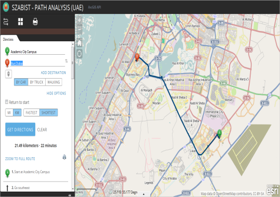
Scenario – 1
Source: Academic City Campus
Destination: Burj Dubai
Analysis path: By Car (Shortest Route)
Map produce by application is shown in Figure 2 bellow:
 PowerPoint Slide
 Larger image(png format)
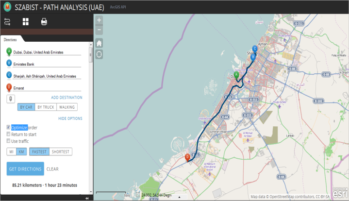
Scenario – 2
Source: Dubai, Dubai, UAE
Banks: Emirates Bank
Source: Sharjah, Ash Shāriqah
Analysis path: By Car (Fastest / Optimize Route)
Petrol Station: Emarat
Multi Destination Map produces by application, from Dubai to Sharja, via Emirates Bank and Emarat Petrol Station, as shown in Figure 3 bellow:
 PowerPoint Slide
 Larger image(png format)
Scenario – 3
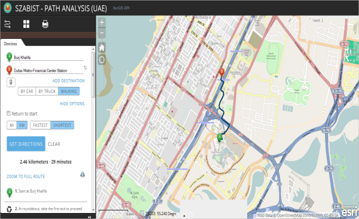
Source: Burj Khalifa
Destination: Dubai Metro-Financial Center Station
Analysis path: By Walk (Shortest Route)
Map produce by application as shown in Figure 4 bellow:
 PowerPoint Slide
 Larger image(png format)
4. Summary
This study aimed to use the ArcGIS API as a tool for analyzing route location and get the shortest, fastest and optimized path within UAE. In this respect there are several Mapping software programs available, but there is no routing analyzer available especially to find shortest, fastest and optimized path within UAE. ArcGIS API was customized, configured for this application in this study and the application named as SZABIST Path Analysis, using external extensions (for example, different types of maps).
The following is Significance of the Study, which are summarized bellow:
• The developed ArcGIS based application (SZABIST Path Analysis) has shown the potential of using GIS technology as a tool to aid in finding shortest, fastest, and optimized route.
• Using GIS based application (SZABIST Path Analysis), proved that there is no restriction of maps and layers. Multiple maps can be used either vector or raster and shows the flexibility of this application. On the other hand as common application Google Maps is restricted to its own maps and not able to add other types of maps as well as not able to find the shortest, fastest or optimized path.
• The application provide functionality to find shortest, fastest and optimized (option is available with more than two destinations) routes to the destination, on the other hand, several applications provides shortest route only.
• This application provide the search functionality by car, truck and walking with restriction distance between any inputs must be less than 50 miles (80 kilometers) when performing search by walking.
• Interface with ArcGIS API application (SZABIST Path Analysis) allows interaction with the capabilities of GIS, so all the GIS capabilities can be added in this application.
• This application is an important application in carrying on the impacts of suggested route on the environmental components. This will assist in reducing the negative effects on these fields and resources.
• The developed application showed high capabilities of dealing with ArcGIS web services for example, showing the designed routes/ street map and simulating a driving experience.
• Bilingual maps having support for Arabic and English.
• Developed application has availability to provide the details by ML (miles) and kilometers (KM) and also calculate the times.
• In this application, search from source to destination provide the complete details of routing, for example how many lefts, rights and roundabouts will come and have availability to print the MAP location in different format (JPG, PND, PDF etc.).
This application (SZABIST Path Analysis) also provides multiple destination to locate nearby bank, patrol station etc., so that user of this application can set more than two destination, for example, before going to office, can withdraw money from ATM and fill the patrol in patrol station (please refer Figure 3, for example).
References
| [1] | Cherkassky, B.V., A.V. Goldberg and T. Radzik, 1993. “Shortest Path Algorithms: Theory and Experimental Evaluation. Technical report 93-1480, Computer Science Department, Stanford University. | ||
 In article In article | |||
| [2] | Yen, J.Y., 1975. Shortest path network problems. (Mathematical Systems in Economics, Heft 18), Hain, Meisennheim am Glan. | ||
| In article | |||
| [3] | ArcGIS Server. (2012). ArcGIS for Server Overview, <http://www.esri.com/software/arcgis/arcgisserver/index.html>, Retrieved Date: 15 May, 2014. | ||
| In article | |||
| [4] | Lo, C.P., Albert K.W. Yeung. 2002. Concepts and Techniques of Geographic Information Systems. New Jersey: Prentice-Hall, Inc. p 212-216. | ||
| In article | |||
| [5] | Belcher, J., Britt, D., Granade, S., Powell, L., & Schle Wssinger, P. (2005) ‘Bus routing algorithms: Application to a rural school district’, ACCLAIM Working Papers 27, Available online at <http://www.acclaim-math.org/docs/Bus.pdf>, (Accessed 27 April 2008). | ||
| In article | |||
| [6] | Yomralioglu, T., (2002) ‘Coğrafi Bilgi Sistemleri Temel Kavramlarve Uygulamalar’, SecilOfset, II. Baskı, Trabzon. | ||
| In article | |||
| [7] | Cormen, T., Leiserson, C., Rivest, R., and Stein, C., 2001. Single-source shortest paths. In: Introduction to algorithms. 2nd ed. Cambridge, MA: MIT Press, 581-635. | ||
| In article | |||
| [8] | Yosef Sheffi, 1992 “Urban Transportation Networks: Equilibrium Analysis with Mathematical Programming Methods”, Published by: Prentice-Hall, Inc. Englewood Cliffs, NJ 07632. | ||
| In article | |||
| [9] | Doleh, R. (2000). The Use of Traffic Assessment Modeling Technique in Evaluating and Testing Transportation Policies and Projects. Master thesis, An-Najah National University, Nablus, Palestine. | ||
| In article | |||
| [10] | Dijkstra, E.W., 1959. A note on two problems inconnexion with graphs. Numerical Mathematics, 1 (1): 269-271. | ||
| In article | CrossRef | ||
| [11] | Sadeghi-Niaraki, A., Varshosaz, M., Kim, K., and Jung, J., 2011. Real world representation of a road network for route planning in GIS. Expert Systems with Applications, 38 (10), 11999-12008. | ||
| In article | CrossRef | ||
| [12] | Avraam, M. (2010). Geo web, web mapping and web GIS, <http://michalisavraam.org/2009/03/geoweb-web-mapping-and-web-gis/>, Retrieved Date: 15 May, 2014. | ||
| In article | |||
| [13] | Panahi, S. and Delavar, M., 2009. Dynamic shortest path in ambulance routing based on GIS. International Journal of Geo informatics, 5 (1), 13-19. | ||
| In article | |||
| [14] | Panahi, S. and Delavar, M., 2009. Dynamic shortest path in ambulance routing based on GIS. International Journal of Geo informatics, 5 (1), 13-19. | ||
| In article | |||
| [15] | TomTom, 2012. Speed profiles [online]. Available from: <https://www.tomtom.com/en_gb/licensing/products/traffic/historical-traffic/speed-profiles/>, Date: 27 May 2013. | ||
| In article | |||
| [16] | ArcGIS API, <http://resources.arcgis.com/en/help/arcgis-rest-api/#/The_ArcGIS_REST_API/02r300000054000000/>, Retrieved Date: 15 Nov, 2014. | ||
| In article | |||

 CiteULike
 Delicious

