This study assesses the relationship between extreme precipitations and reservoir sedimentation dynamics in the Beninese portion of the Niger River Basin. Historical daily rainfall data (1980-2020) and future climate projections (2021-2049) from the WRF regional climate model under the RCP 4.5 scenario were analyzed to assess trends in extreme rainfall using the Modified Mann-Kendall test and the Theil-Sen slope estimator. The impacts of changing heavy rainfall patterns on runoff and sediment yield were simulated using the Soil and Water Assessment Tool (SWAT), applied to the Sota catchment. The findings reveal mixed heavy rainfall trends across the study area, with a significant decrease projected under the RCP 4.5 scenario for several stations. The SWAT model showed satisfactory performance for streamflow simulation (NSE = 0.70 during calibration; 0.66 during validation). The historical mean sediment yield was estimated at 18.6 ton ha⁻¹yr⁻¹, exceeding commonly accepted sustainability thresholds. Spatial analysis revealed persistent sedimentation hotspots in the southwestern part of the catchment. Future simulations indicate an increase in runoff but a decline in sediment yield to 12.8 ton ha⁻¹ yr⁻¹ by 2049. This counterintuitive trend is attributed to a projected shift toward less erosive rainfall regimes coupled with temperature-driven changes in soil surface processes. While providing valuable insights into climate-sediment interactions, these projections are subject to uncertainties from the lack of measured sediment data, the use of a single climate scenario, and the assumption of static land use. Overall, the study highlights the sensitivity of reservoir sedimentation to changes in extreme rainfall and provides a scientific basis for improving sediment management strategies in small dams under future climate change.
Climate change is projected to disrupt hydrological regimes and exacerbate uncertainty in global water supplies, with vulnerable regions like West Africa being particularly affected 1. To enhance water security, reservoirs have been constructed worldwide to regulate water for hydropower, irrigation, flood control, and domestic supply 2, 3, 4. However, the long-term functionality of these vital infrastructures is threatened by reservoir sedimentation.
In West Africa, where small dams are critical for agricultural production, pastoral activities, aquaculture, and domestic water supply, this threat is acute. In the Sahelo-Sudanian region, sedimentation processes are strongly influenced by climate variability, particularly shifts in extreme precipitations, which accelerate soil erosion and sediment delivery to reservoirs 5. An observed intensification of heavy rainfall events across parts of sub-Saharan Africa 6, 7, 8 signals a potential acceleration of catchment degradation and sediment yields. Nevertheless, the specific contribution of extreme precipitations to sedimentation dynamics remains poorly documented in many basins.
This knowledge gap is pronounced in the Niger River Basin of northern Benin, which hosts approximately 87% of the country's small reservoirs 9. Existing local studies have either quantified sedimentation rates 10, 11 or analyzed sediment contamination 12. Recent hydrological assessments have focused on long-term rainfall trends or water quality 13, 14, 15 but have not explicitly examine how extreme precipitation patterns modulate sediment yield and reservoir infilling. As a result, a significant knowledge gap persists regarding the sensitivity of reservoir sedimentation processes to climate-induced changes in rainfall extremes. Furthermore, the temporal evolution of sediment accumulation under future climate scenarios remains unquantified, limiting adaptive management capacity.
This study addresses these gaps by examining the relationship between extreme rainfall patterns and reservoir sedimentation dynamics in northern Benin. We employ historical climate data and Weather Research and Forecasting (WRF) model projections to analyze trends in daily precipitation extremes for the period 1981-2049. Subsequently, we use the Soil and Water Assessment Tool (SWAT) to simulate resulting streamflow and sediment yield, evaluating how projected changes in rainfall intensity may alter sedimentation rates in the Sota catchment, a representative area with multiple small reservoirs.
Our work provides a process-based assessment of how catchment-scale sediment export responds to current and future rainfall extremes. Specifically, it contributes to regional hydrological research by: (i) quantifying historical and projected trends in extreme rainfalls; (ii) evaluating the implications of these trends for catchment sediment yield; and (iii) identifying potential hotspots of future reservoir sedimentation risk. The findings are designed to inform sustainable management and resilience planning for small dam infrastructure in this climate-vulnerable region.
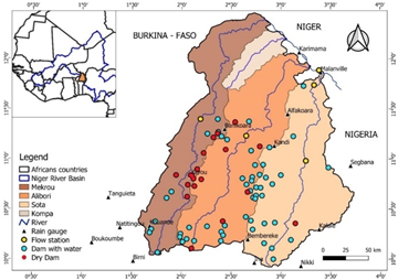
The study area encompasses the Beninese portion of the Niger River Basin, which is geographically defined by the longitudes 1°50'-3°45'W and the latitudinal range of 10°0'-12°30', covering a total area of 39,726 km2 (Figure 1) 16. The region features a Sudano-Sahelian climate in the north and a Sudanese climate in the south. It is characterized by a unimodal rainfall regime, with a single rainy season from April to October followed by a dry season from November to March 18. The mean annual precipitation is approximately 936 mm 19, while daily maximum wind speeds can reach 9.5 m s-1 per day 16. The mean minimum and mean maximum temperatures are 21.5°C and 34.6°C, respectively. According to the Comprehensive Data Repository of the Benin Water Directorate of 2019, the area contains 73 dams, accounting for 87% of the country's small dams 17.
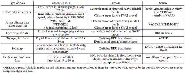
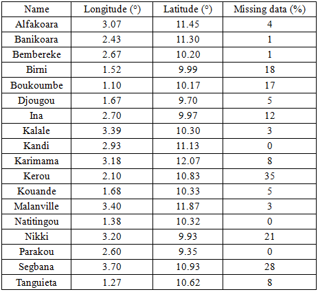
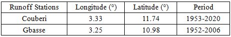
The data used in this study are presented in Table 1. The climatic stations employed in this study, along with the associated percentage of missing data, are presented in Table 2.
The data from the stations at Kerou, Nikki, and Segbana were excluded from subsequent analysis due to extensive missing data (>20%), a threshold chosen to minimize potential bias 18.
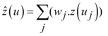
To address data gaps and given the limited number of rain gauges in the study area, the inverse distance weighting (IDW) method, a deterministic spatial interpolation technique (Equation 1), was selected 16.
 | (1) |
with  ,
,  and
and 
where  is the interpolated value at location j,
  the weight of the observed value at the location j,
  the observed value at station j,
  the distance to station j, and p the weighting power of the inverse distance (between 1 and 3; 2 was taken in this study).
Table 3 lists the gauging stations used in the study.
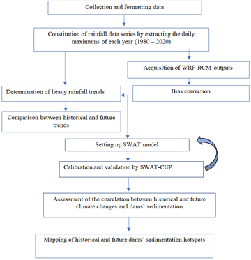
This study assesses trends in historical and projected heavy rainfall and models their impact on dam sedimentation. Figure 2 gives an overview of the methodology applied.
The historical rainfall time series comprised annual maximum daily precipitation data from 15 rain gauges (1980-2020). Future rainfall projections were acquired from WASCAL/KIT/IMK-IFU () for the Regional Climate Models (RCMs) WRF-GFDL and WRF-hadGEM2 under the RCP 4.5 scenario for the 2021-2049 period. These RCM datasets, at a 12 km resolution, were bias-corrected using the linear scaling method within the Climate Model Data for Hydrologic Modeling (CmHyd, version 10.2) software 19.
The performance of the bias correction was evaluated using three metrics: the coefficient of determination (R², Equation 2), the percent bias (PBIAS, Equation 3), and the Nash-Sutcliffe efficiency (NSE) coefficient (Equation 4) 20, to compare raw and bias-corrected model outputs against observed data.
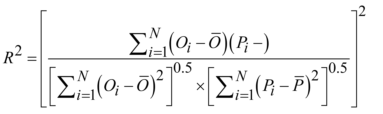 | (2) |
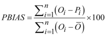 | (3) |
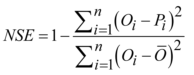 | (4) |
where Oi is the observed value and Pi is the simulated or biased-corrected value.
Subsequently, the Modified Mann-Kendall test 21 and Theil-Sen slope estimator 22 were employed to detect trends and quantify their magnitudes in annual maximum precipitation series for both the historical and future periods. This analysis enabled a comparative assessment of projected changes in the frequency and magnitude of heavy rainfall events for the future period (2021-2049) relative to the historical baseline (1980-2020).
The Soil and Water Assessment Tool (SWAT, version 2012) was employed to assess the impact of heavy rainfall patterns on dam sedimentation. The model simulates the hydrological cycle based on the following water-balance equation 23.
 | (5) |
where SWt is the soil water content (mm), SW0 is the water available to plants (mm), Rday is the daily precipitation (mm), Qsurf is the surface runoff (mm), Eα is the evapotranspiration (mm), Wseep is the percolation (mm), Qgw is the low flow (mm) and t is the time (days).
Surface runoff was estimated using the Soil Conservation Service (SCS) curve number equation while the sediment yield was calculated for each hydrologic response unit (HRU) using the Modified Universal Soil Loss Equation (MUSLE) 24.
where sed is the sediment yield on a given day (tons), Qsurf is the surface runoff volume (mm /ha), qpeak is the peak runoff rate (m3/s), Areahru is the area of the HRU (ha), KUSLE is the USLE soil erodability factor (), CUSLE is the USLE cover and management factor (-), PUSLE is the USLE support practice factor (-), LSUSLE is the USLE topographic factor and CFRG is the coarse fragment factor (-).
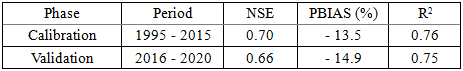
For the Sota catchment, the model was configured using ArcGIS 10.7 interface. The catchment was delineated and subdivided into sub-catchments using the ASTER DEM and dams were integrated into the model based on their respective sub-catchment locations. A sensitivity analysis was performed using the SWAT Calibration and Uncertainty Procedures (SWAT-CUP) tool 25. A five-year (1990-1994) served as warmup period. The sequential uncertainty fitting (SUFI-2) approach was used for model calibration (1995-2015) and validation (2016-2020), with performance metrics computed using the R-based Hydrological Goodness-of-Fit package. Model performance was evaluated using the coefficient of determination (R²), percent bias (PBIAS), and the Nash-Sutcliffe efficiency (NSE), consistent with the approach of 26.
Owing to the unavailability of measured sediment flux data, the calibrated and validated SWAT model was used to quantify streamflow and sediment yield for the historical (1980-2020) and future (2021-2049) periods, following the methodology of 27. Future climate projections from the WRF models served as inputs to simulate future streamflow and sediment yield.
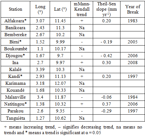
The trends in heavy rainfall over Northern Benin and their magnitude are presented in Table 4.
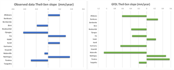
Of the 15 rainfall stations, only five (Alfakoara, Birni, Djougou, Kandi, and Natitingou) showed statistically significant trends (p-value < 0.05). No clear spatial pattern or consistent direction in trends was detected. The heterogeneity in trends among stations within the same climatic zone is attributable to factors such as the percentage of missing data (See Table 2), and the high climatic variability in the West African region during the past decades 3, 28.
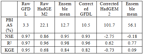
3.2. Trends in Future Heavy RainfallThe performance of the raw and bias-corrected outputs from the two RCMs, WRF-HadGEM2 and WRF-GFDL, and their ensemble mean is presented in Table 5.
A comparison with observed data revealed that the raw WRF-GFDL model demonstrated superior performance in capturing precipitation dynamics over the study area compared to its bias-corrected counterpart and the ensemble mean. Consequently, the raw WRF-GFDL output was selected for subsequent analysis. This finding is consistent with a previous study in northern Nigeria, a region with a similar Sudano-Sahelian climate, which also reported a tendency for the HadGEM2-ES model to overestimate precipitation 29.
Projections from the GFDL-WRF model indicate a statistically significant shift in heavy rainfall patterns at 67% of the stations in the future compared to the historical baseline, with 60% of these stations exhibiting a decreasing trend (Figure 3).
These results are consistent with the findings of 30 , who also projected declining extreme rainfall indices for several stations in Benin's Ouémé catchment by mid-century under the RCP 4.5 scenario. In contrast, a study by 31 projected an increase of 1.5 in the annual maximum daily rainfall over the Kolkata Metropolitan Area (India) by the end of the century (2071-2100) under the same RCP4.5 scenario. This discrepancy underscores the substantial geographical variability in climate change projections. Furthermore, 31 suggest that while the RCP 4.5 scenario typically projects moderate changes, localized intensification of extremes can occur due to the interplay between global warming and regional climatic dynamics.
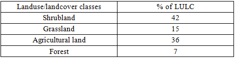
The analysis of land use and land cover (LULC) for the Sota catchment (Table 6) identifies shrubland and agricultural land as the predominant classes, covering 46% and 36% of the area, respectively.
The SWAT model delineated 25 sub-catchments and 120 hydrological response units (HRU). The spatial configuration and hydrological connectivity of dams within the sub-catchment network are presented in Figure 4.
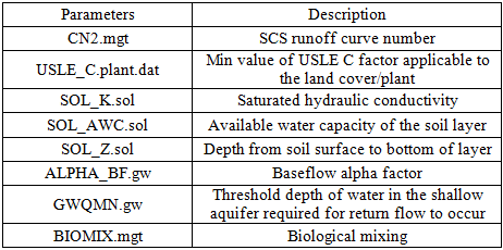
Model calibration was performed using eight sensitive parameters (Table 7). These parameters govern key hydrological processes, including surface runoff (CN2.mgt, USLE_C.plant.dat), infiltration (BIOMIX.mgt), soil properties (SOL_K.sol, SOL_AWC.sol, SOL_Z.sol), and groundwater flow (ALPHA_BF.gw, GWQMN.gw).
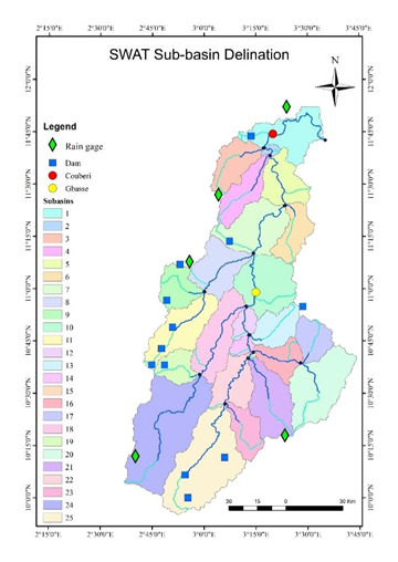
Table 8 presents the model performance statistics for the calibration and validation periods. The NSE values exceed 0.65, the R2 values surpass 0.7, and the PBIAS values fall within the range ±10% to ±15% for both periods, indicating a satisfactory model performance.
Figure 5 presents the spatial variability of sediment yield simulated by the SWAT model for both the baseline and future periods. The results indicate that dams in the southwestern and western regions of the Sota catchment are sedimentation hotspots. In contrast, dams located in the central area exhibit lower sediment yields.
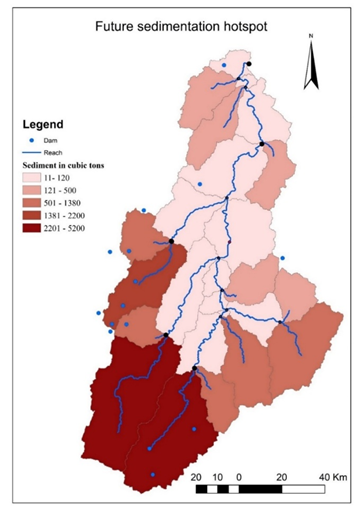
The simulated historical sediment yield averaged 18.6 ton ha-1 yr-1 for the Sota catchment, exceeding widely reported sustainability thresholds of 11 ton ha-1yr-1 32, 33. Our values are comparable to sediment yields of 12.54 to 15.17 ton ha-1yr-1 documented in similar West African and East African basins affected by land degradation and intense rainfall events 34, 35. While some studies in humid regions reported lower sediment yields, of for example 0.5 ton ha-1yr-1 in the Ouémé catchment 36 and 0.014 ton ha-1yr-1 the Aghien Lagoon catchment 37, differences in soil erodibility, land use, and climatic conditions explain these contrasts.
A key contribution of this study is the explicit assessment of extreme precipitations as a driver of sediment yield and dams’ sedimentation. Prior works in the region have either examined rainfall variability and/or reservoir sedimentation, but few studies have directly linked changing rainfall extremes to reservoir sedimentation 38. Indeed, while some regional studies analyzed rainfall erosivity 39, 40, others using the SWAT model focused on reservoir sedimentation 41, 42, but the African literature remains sparse on this point compared to the global literature 38, 43. Thus, by combining extreme precipitation trend analysis with reservoir sedimentation, the present research demonstrates that sedimentation patterns in small reservoirs respond not only to total rainfall but also to shifts in extreme rainfall intensity.
Projections for the near-future period reveal a divergent trend between runoff and sediment yield. Whereas simulated runoff is projected to increase from 113.36 mm yr-1 to 297.92 mm yr-1, the sediment yield is projected to decrease from 18.6 to 12.8 ton ha-1yr-1. While this may appear counterintuitive, several mechanisms explain this decoupling. First, our results suggest a shift toward less erosive rainfall regimes, characterized by a decreasing trend in future heavy rainfall (See Section 3.2.2.). Similar findings were reported by 30 and 44 who found trends consistent with our results. Second, rising temperatures may enhance soil surface drying and crusting, reducing detachment efficiency, a mechanism also identified by 45
Nevertheless, the non-quantification of erosivity indices (e.g., R-factor) limits the depth of interpretation. Future work should compute erosivity metrics to strengthen the causal linkage between rainfall intensity and sediment response.
Spatially, the southwestern part of the catchment is projected to remain the most vulnerable to sedimentation in the near future, highlighting the necessity for sustainable management practices such as filter strips, soil or stone bunds, contour farming and terracing 46. For immediate risk mitigation, desilting the small dams in this area could be a viable solution 47.
This study has several limitations that should be acknowledged. First, due to the absence of measured sediment flux data, SWAT sediment outputs could not be fully validated. As a result, sediment yield estimates should be interpreted as indicative rather than absolute values, consistent with similar data-constrained studies in Africa. Second, only a single climate scenario (RCP 4.5) was considered, limiting the robustness of future projections. Incorporating multiple scenarios (e.g., SSP2-4.5, SSP5-8.5) would provide a more comprehensive uncertainty range. Third, rainfall erosivity was not quantified; therefore, the inferred explanation for declining sediment yield under future conditions remains qualitative. Fourth, land use was assumed to remain static in future simulations, whereas agricultural expansion and land degradation are ongoing processes in northern Benin. This assumption may underestimate future sediment yield, as dynamic land use change is known to significantly alter erosion patterns 48.
This study analyzed historical and projected changes in extreme precipitations and assessed their implications for reservoir sedimentation in northern Benin. Historical daily rainfall data (1980-2020) and future climate projections (2021-2049) from the WRF regional climate model under the RCP 4.5 scenario were analyzed to assess trends in extreme rainfall using the Modified Mann-Kendall test and the Theil-Sen slope estimator. Results indicate heterogeneous historical trends in heavy rainfall, with a statistically significant shift toward decreasing extremes projected for more than 40% of the stations.
The impacts of changing heavy rainfall patterns on runoff and reservoir sedimentation were simulated using the SWAT model applied to the Sota catchment. The model produced satisfactory performance for streamflow simulation and estimated an alarming sediment yield (18.6 ton ha⁻¹.yr⁻¹) during the baseline period, particularly in the southwestern part of the Sota catchment. Future simulations suggest a decline in sediment yield (12.8 ton ha⁻¹. yr⁻¹ by 2049.) despite increasing runoff, likely reflecting a transition toward less erosive rainfall conditions and temperature-induced changes in soil surface processes. These findings highlight the sensitivity of reservoir sedimentation to changes in extreme rainfall patterns.
The identification of persistent sedimentation hotspots provides valuable insights for future watershed management planning. Further research incorporating dynamic land-use scenarios, multi-scenario climate projections, and measured sediment data is essential to refine sediment forecasts and support sustainable reservoir operation in the region.
The authors acknowledge with gratitude the financial support of the International Foundation for Science (Grant No. I2-W-6663-1).
The authors declare no conflict of interests.
| [1] | UNESCO, The United Nations World Water Development Report 2020: Water and Climate Change. Paris: UNESCO, 2020. | ||
| In article | |||
| [2] | WWAP, (UNESCO World Water Assessment Programme). The United Nations World Water Development Report 2019. Paris: UNESCO, 2019. | ||
| In article | |||
| [3] | Ristić, R., Ljujić, M., Despotović, J., Aleksić, V., Radić, B., Nikić, Z., Milčanović, V., Malušević, I., and Radonjić, J, “Reservoir sedimentation and hydrologcal effects of land use changes - case study of the experimental DIČINA River Watershed,” Carpathian Journal of Earth and Environmental Sciences, vol. 8, no. 1, pp. 91–98, 2013. | ||
| In article | |||
| [4] | EL Bilali, A., Taleb, A., EL Idrissi, B., Brouziyne, Y., and Mazigh, N., “Comparison of a data-based model and a soil erosion model coupled with multiple linear regression for the prediction of reservoir sedimentation in a semi-arid environment,” EuroMediterr J Environ Integr, vol. 5, no. 3, p. 64, Dec. 2020. | ||
| In article | View Article | ||
| [5] | Lienou, G., Mahé, G., Dieulin, C., Paturel, J. E., Bamba, F., Sighomnou, D., and Dessouassi, R., "The River Niger water availability: facing future needs and climate change," in Global Change: Facing Risks and Threats to Water Resources (Proc. of the Sixth World FRIEND Conference, Fez, Morocco, October 2010), IAHS Publ. 340, pp. 637–645, 2010. | ||
| In article | |||
| [6] | Ayanlade, A., Oluwaranti, A., Ayanlade, O. S., Borderon, M., Sterly, H., Sakdapolrak, P., Jegede, M. O., Weldemariam, L. F., and Ayinde, A. F. O, “Extreme climate events in sub-Saharan Africa: A call for improving agricultural technology transfer to enhance adaptive capacity,” Clim Serv, vol. 27, p. 100311, Aug. 2022. | ||
| In article | View Article | ||
| [7] | Siabi, E. K., Awafo, E. A., Kabobah, A. T., Derkyi, N. S. A., Akpoti, K., Anornu, G. K., and Yazdanie, M., “Quantifying future climate extreme indices: implications for sustainable urban development in West Africa, with a focus on the greater Accra region,” Discover Sustainability, vol. 5, no. 1, p. 167, Jul. 2024. | ||
| In article | View Article PubMed | ||
| [8] | Aryee, J. N. A., Afrifa, F. O. T., Agyapong, K.-H., Gyau Frimpong, N. A., Quagraine, K. T., and Davies, P., “Quantifying climatic heavy-precipitation-induced floods in West Africa using multiple precipitation indices,” Sci Afr, vol. 25, p. e02309, Sep. 2024. | ||
| In article | View Article | ||
| [9] | Azonsi, F., Tossa, A., Kpomasse, M., Lanhoussi, F., Zannou, A., and Gohoungossou, A., “Atlas hydrographique du Bénin. Un Système d ’Information sur l’hydrographie,” Cotonou, Benin, 2008. [Online]. Available: https:// www.slideshare.net/ slideshow/ atlas-hydrographique-du-bnin/51213104. | ||
| In article | |||
| [10] | Ibouraima, S., Oyédé, L. M., and Sinsin, B. A., “Contribution de la vase au comblement des retenues d’eau de Gogbèdè et Guéné dans le Département de l’Alibori au Nord-Est du Bénin,” Bulletin de la Recherche Agronomique du Bénin (BRAB, vol. 73, pp. 20–27, 2013, [Online]. Available: 1840-7099. | ||
| In article | |||
| [11] | Hountondji, B., Codo, F. P., Ahoumenou, Y., Sintondji, L. O., and Ahouansou, M., "Infiltration des eaux et des dépôts dans la retenue du mini-barrage de Wourowourokou dans le nord du Benin," Larhyss Journal, vol. 39, pp. 201–214, 2019. | ||
| In article | |||
| [12] | Pélébé, R. O. E., Ouattara, I. N., Attakpa, E. Y., Dimon Yai, B. W., Dassoundo-Assogba, J. C. F., Imorou Toko, I., and Montchowui, E. H., "Caractérisation de l'état actuel et des modes d'exploitation des retenues d'eau au Bénin," Annales de l'Université de Parakou, Série Sciences Naturelles et Agronomie, vol. 9, no. 2, pp. 1–14, 2019. | ||
| In article | View Article | ||
| [13] | Sambieni, K.S., Hountondji, F.C.C., Sintondji, L.O., Fohrer, N., Biaou, S., and Sossa, C.L.G. "Climate and Land Use/Land Cover Changes within the Sota Catchment (Benin, West Africa)". Hydrology. 11 (3), 30 2024. | ||
| In article | View Article | ||
| [14] | Ganni Mampo, O.M., Guedje, K.F., Merz, B., Obada, E., Guntu, R.K., Yarou, H., et al. Rainfall and Streamflow Variability in North Benin, West Africa, and Its Multiscale Association With Climate Teleconnections. Journal of Hydrology: Regional Studies. 59 102319, 2025. | ||
| In article | View Article | ||
| [15] | Orou Piami, Z., Akodogbo, H. H., Gouissi, F. M., Abahi, K. S., Idrissou, Y., and Gnohossou, M. P., "Effet de l'assèchement sur les caractéristiques physico-chimiques des eaux de ruisseaux affluents des rivières Alibori et Sota au nord Bénin," Revue Marocaine des Sciences Agronomiques et Vétérinaires, vol. 11, no. 1, pp. 22–29, 2023. | ||
| In article | |||
| [16] | Badou, D. F., Kapangaziwiri, E., Diekkrüger, B., and Afouda, A., “Evaluation of recent hydro-climatic changes in four tributaries of the Niger River Basin (West Africa),” Hydrological Sciences Journal, vol. 62, pp. 715–728, 2016. | ||
| In article | View Article | ||
| [17] | ProSEHA-GIZ, “Rapport d’inventaire des retenues d’eau (barrages, surcreusements de mares) du Bénin,” 2019. Cotonou, Bénin. | ||
| In article | |||
| [18] | Toure, M., Klutse, N. A. B., Sarr, M. A., Bhuiyan, M. A. E., Kenne, A. D., Thiaw, W. M., Badiane, D., Gaye, A. T., Ndiaye, O., and Mbow, C., “Machine learning approaches for imputing missing meteorological data in Senegal,” Applied Computing and Geosciences, vol. 27, p. 100281, Sep. 2025. | ||
| In article | View Article | ||
| [19] | Rathjens, H., Bieger, K., Srinivasan, R., and Arnold, J. G., “CMhyd User Manual Documentation for preparing simulated climate change data for hydrologic impact studies,” 2016. | ||
| In article | |||
| [20] | Nash, J. E., and Sutcliffe, J. V, “River Flow Forecasting Through Conceptual Models - Part I - A Discussion of Principles,” J Hydrol (Amst), vol. 10, no. 1970, pp. 282–290, 1970. | ||
| In article | View Article | ||
| [21] | Hamed, K. H., and Ramachandra Rao, A., “A modified Mann-Kendall trend test for autocorrelated data,” J Hydrol (Amst), vol. 204, no. 1–4, pp. 182–196, Jan. 1998. | ||
| In article | View Article | ||
| [22] | Sen, P. K., “Estimates of the Regression Coefficient Based on Kendall’s Tau,” J Am Stat Assoc, vol. 63, no. 324, pp. 1379–1389, Dec. 1968. | ||
| In article | View Article | ||
| [23] | Laftouhi, A. M. N., and Soulaimani, Y. G. A., “Assessment of potential soil erosion and sediment yield in the semi-arid N′fis basin (High Atlas , Morocco) using the SWAT model,” Acta Geophysica, no. 0123456789, 2019. | ||
| In article | |||
| [24] | Neitsch, S. L., Arnold, J. R., Kiniry, J. R., and Williams, J. R., “Soil and Water Assessment Tool Theoretical Documentation Version 2009. Technical Report 406,” 2011. https:// swat.tamu.edu /media/1292/swat2005theory.pdf. | ||
| In article | |||
| [25] | Arnold, J. G., Moriasi, D. N., Gassman, P. W., Abbaspour, K. C., White, M. J. , Srinivasan, R., Santhi, C., Harmel, R. D., Griensven, A., van Liew, M. W., Van Kannan, N., and Jha, M. K., “Swat: Model use, Calibration and Validation.,” American Society of Agricultural and Biological Engineers, vol. 55, no. 4, pp. 1491–1508, 2012. | ||
| In article | View Article | ||
| [26] | Larbi, I., Hountondji, F. C. C., Dotse, S., Mama, D., Nyamekye, C., Adeyeri, O. E., Koubodana, H. D., Odoom, E. R. P., and Asare, M. Y., “Local climate change projections and impact on the surface hydrology in the Vea catchment , West Africa,” Hydrology Research, vol. 52, no. 6, pp. 1200–1215, 2021. | ||
| In article | View Article | ||
| [27] | Hallouz, F., Meddi, M., Mahé, G., Alirahmani, S., and Keddar, A., “Modeling of discharge and sediment transport through the SWAT model in the basin of Harraza (Northwest of Algeria),” Water Science, vol. 32, no. 1, pp. 79–88, Apr. 2018. | ||
| In article | View Article | ||
| [28] | Mason, S. J., Waylen, P. R., Mimmack, G. M., Rajaratnam, B., and Harrison, J. M., “Changes In Extreme Rainfall Events In South Africa,” Clim Change, vol. 41, pp. 249–257, 1999. | ||
| In article | View Article | ||
| [29] | Dike, V. N., Shimizu, H., Diallo, M., and Lin, Z., “Modelling present and future African climate using CMIP5 scenarios in HadGEM2-ES,”International Journal of Climatology, no. June, 2015. | ||
| In article | View Article | ||
| [30] | N’Tcha M’Po, Y., Lawin, E., Yao, B., Oyerinde, G., Attogouinon, A., and Afouda, A., “Decreasing Past and Mid-Century Rainfall Indices over the Ouémé River Basin, Benin (West Africa),” Climate, vol. 5, no. 3, p. 74, Sep. 2017. | ||
| In article | View Article | ||
| [31] | Malik, S., Pal, C. S., Sattar, A., Singh, K. S., Das, B., Chakrabortty, R., and Mohammad, P., “Trend of extreme rainfall events using suitable Global Circulation Model to combat the water logging condition in Kolkata Metropolitan Area,” Urban Clim, vol. 32, no. March, pp. 1–15, 2020. | ||
| In article | View Article | ||
| [32] | Dibaba, W. T., Demissie, T. A., and Miegel, K., “Prioritization of Sub-Watersheds to Sediment Yield and Evaluation of Best Management Practices in Highland Ethiopia, Finchaa Catchment,” Land (Basel), vol. 10, no. 6, p. 650, Jun. 2021. | ||
| In article | View Article | ||
| [33] | Tsegaye, L., and Bharti, R., “Soil erosion and sediment yield assessment using RUSLE and GIS-based approach in Anjeb watershed, Northwest Ethiopia,” SN Appl Sci, vol. 3, no. 5, p. 582, May 2021. | ||
| In article | View Article | ||
| [34] | Welde, K., and Gebremariam, B, “Effect of land use land cover dynamics on hydrological response of watershed: Case study of Tekeze Dam watershed, northern Ethiopia,” International Soil and Water Conservation Research, vol. 5, no. 1, pp. 1–16, Mar. 2017. | ||
| In article | View Article | ||
| [35] | Kuma, H.G., Chinasho, E.M., Abrham Asha Tolke, A.A., Assessment of sediment yield and accumulation in reservoir: The case of Gibe One Reservoir, Southwestern Ethiopia, Heliyon, vol.10, n°17, 2024. | ||
| In article | View Article PubMed | ||
| [36] | Bossa, A. Y., Diekkrüger, B., Giertz, S., Steup, G., Sintondji, L. O., Agbossou, E. K., and Hiepe, C., “Modeling the effects of crop patterns and management scenarios on N and P loads to surface water and groundwater in a semi-humid catchment (West Africa),” Agric Water Manag, vol. 115, pp. 20–37, Dec. 2012. | ||
| In article | View Article | ||
| [37] | N’dri, W. K. C., Pistre, S., Kouamé, K. J., and Jourda, J. P, “Potential Impact of Climate Change on the Sediment Fluxes of a Watershed in West Africa: Cas of the Aghien Lagoon, Côte d’Ivoire,” Atmospheric and Climate Sciences, vol. 12, no. 01, pp. 18–30, 2022. | ||
| In article | View Article | ||
| [38] | Li, E., “Effects of Extreme Rainfall Change on Sediment Load in the Huangfuchuan Watershed, Loess Plateau, China”, Sustainability, vol.16, n°17. | ||
| In article | View Article | ||
| [39] | Adeyeri, O.E., Folorunsho, A.H., Adeliyi, T.E., Ayegbusi, K.I., Akinsanola, A.A., Christopher E. Ndehedehe,C.E., Naveed Ahmed, N., Babalola, T.E., “Climate change is intensifying rainfall erosivity and soil erosion in West Africa” Science of The Total Environment, vol. 955, 2024. | ||
| In article | View Article PubMed | ||
| [40] | Knight J, Abd Elbasit, M.A.M.., “Spatial and Temporal Patterns of Rainfall Erosivity in Southern Africa in Extreme Wet and Dry Years”. Atmosphere, vol.15, n°11, 2024. | ||
| In article | View Article | ||
| [41] | Tessema, Y.M., Zimale, F.A., Kebedew, M.G., “Understanding sedimentation trends to enhance sustainable reservoir management in the Angereb reservoir, Upper Blue Nile Basin, Ethiopia”, Frontiers in Water, vol.6, 2024. | ||
| In article | View Article | ||
| [42] | Woldemariam, A.D., Ddumba, S.D., Addis, H.K., “Modeling Sediment Yield with Current and Projected Climatic Scenarios in Andit Tid Watershed, Central Highland of Ethiopia”, Journal of Agriculture and Environment for International Development, vol. 118, 2024. | ||
| In article | View Article | ||
| [43] | Ren, Z., Ma, X., Wang, K., Li, Z., “Effects of Extreme Precipitation on Runoff and Sediment Yield in the Middle Reaches of the Yellow River”, Atmosphere, vol.14, n°9, 2023. | ||
| In article | View Article | ||
| [44] | Armon, M., Marra, F., Enzel, Y., Rostkier-Edelstein, D., Garfinkel, C.I., Adam, O., Dayan, U., and Morin, E. “Reduced rainfall in future heavy precipitation events related to contracted rain area despite increased rain rate”. Earth's Future. 10 (1), e2021EF002397, 2022. | ||
| In article | View Article | ||
| [45] | Zhang, S., Li, Z., Hou, X., and Yi, Y., “Impacts on watershed-scale runoff and sediment yield resulting from synergetic changes in climate and vegetation,” Catena (Amst), vol. 179, pp. 129–138, Aug. 2019. | ||
| In article | View Article | ||
| [46] | Regasa, M. S., and Nones, M., “Modeling best management practices to reduce future sediment yield in the Fincha watershed, Ethiopia,” International Journal of Sediment Research, vol. 39, no. 5, pp. 737–749, Oct. 2024. | ||
| In article | View Article | ||
| [47] | Remini, B., “Sustainable desilting of dams,” Larhyss Journal, vol. 51, pp. 211–236, 2022, [Online]. Available: http:// larhyss.net/ ojs/index.php/larhyss/index. | ||
| In article | View Article | ||
| [48] | Bihonegn, B.G., Awoke, A.G., “Evaluating the impact of land use and land cover changes on sediment yield dynamics in the upper Awash basin, Ethiopia the case of Koka reservoir”, Heliyon, Vol. 9, n° 12, 2023. | ||
| In article | View Article PubMed | ||
Published with license by Science and Education Publishing, Copyright © 2026 Djigbo Félicien BADOU, Audrey Merveille ADANGO and Chaim Vivien DOTO
![]() This work is licensed under a Creative Commons Attribution 4.0 International License. To view a copy of this license, visit
http://creativecommons.org/licenses/by/4.0/
This work is licensed under a Creative Commons Attribution 4.0 International License. To view a copy of this license, visit
http://creativecommons.org/licenses/by/4.0/
| [1] | UNESCO, The United Nations World Water Development Report 2020: Water and Climate Change. Paris: UNESCO, 2020. | ||
| In article | |||
| [2] | WWAP, (UNESCO World Water Assessment Programme). The United Nations World Water Development Report 2019. Paris: UNESCO, 2019. | ||
| In article | |||
| [3] | Ristić, R., Ljujić, M., Despotović, J., Aleksić, V., Radić, B., Nikić, Z., Milčanović, V., Malušević, I., and Radonjić, J, “Reservoir sedimentation and hydrologcal effects of land use changes - case study of the experimental DIČINA River Watershed,” Carpathian Journal of Earth and Environmental Sciences, vol. 8, no. 1, pp. 91–98, 2013. | ||
| In article | |||
| [4] | EL Bilali, A., Taleb, A., EL Idrissi, B., Brouziyne, Y., and Mazigh, N., “Comparison of a data-based model and a soil erosion model coupled with multiple linear regression for the prediction of reservoir sedimentation in a semi-arid environment,” EuroMediterr J Environ Integr, vol. 5, no. 3, p. 64, Dec. 2020. | ||
| In article | View Article | ||
| [5] | Lienou, G., Mahé, G., Dieulin, C., Paturel, J. E., Bamba, F., Sighomnou, D., and Dessouassi, R., "The River Niger water availability: facing future needs and climate change," in Global Change: Facing Risks and Threats to Water Resources (Proc. of the Sixth World FRIEND Conference, Fez, Morocco, October 2010), IAHS Publ. 340, pp. 637–645, 2010. | ||
| In article | |||
| [6] | Ayanlade, A., Oluwaranti, A., Ayanlade, O. S., Borderon, M., Sterly, H., Sakdapolrak, P., Jegede, M. O., Weldemariam, L. F., and Ayinde, A. F. O, “Extreme climate events in sub-Saharan Africa: A call for improving agricultural technology transfer to enhance adaptive capacity,” Clim Serv, vol. 27, p. 100311, Aug. 2022. | ||
| In article | View Article | ||
| [7] | Siabi, E. K., Awafo, E. A., Kabobah, A. T., Derkyi, N. S. A., Akpoti, K., Anornu, G. K., and Yazdanie, M., “Quantifying future climate extreme indices: implications for sustainable urban development in West Africa, with a focus on the greater Accra region,” Discover Sustainability, vol. 5, no. 1, p. 167, Jul. 2024. | ||
| In article | View Article PubMed | ||
| [8] | Aryee, J. N. A., Afrifa, F. O. T., Agyapong, K.-H., Gyau Frimpong, N. A., Quagraine, K. T., and Davies, P., “Quantifying climatic heavy-precipitation-induced floods in West Africa using multiple precipitation indices,” Sci Afr, vol. 25, p. e02309, Sep. 2024. | ||
| In article | View Article | ||
| [9] | Azonsi, F., Tossa, A., Kpomasse, M., Lanhoussi, F., Zannou, A., and Gohoungossou, A., “Atlas hydrographique du Bénin. Un Système d ’Information sur l’hydrographie,” Cotonou, Benin, 2008. [Online]. Available: https:// www.slideshare.net/ slideshow/ atlas-hydrographique-du-bnin/51213104. | ||
| In article | |||
| [10] | Ibouraima, S., Oyédé, L. M., and Sinsin, B. A., “Contribution de la vase au comblement des retenues d’eau de Gogbèdè et Guéné dans le Département de l’Alibori au Nord-Est du Bénin,” Bulletin de la Recherche Agronomique du Bénin (BRAB, vol. 73, pp. 20–27, 2013, [Online]. Available: 1840-7099. | ||
| In article | |||
| [11] | Hountondji, B., Codo, F. P., Ahoumenou, Y., Sintondji, L. O., and Ahouansou, M., "Infiltration des eaux et des dépôts dans la retenue du mini-barrage de Wourowourokou dans le nord du Benin," Larhyss Journal, vol. 39, pp. 201–214, 2019. | ||
| In article | |||
| [12] | Pélébé, R. O. E., Ouattara, I. N., Attakpa, E. Y., Dimon Yai, B. W., Dassoundo-Assogba, J. C. F., Imorou Toko, I., and Montchowui, E. H., "Caractérisation de l'état actuel et des modes d'exploitation des retenues d'eau au Bénin," Annales de l'Université de Parakou, Série Sciences Naturelles et Agronomie, vol. 9, no. 2, pp. 1–14, 2019. | ||
| In article | View Article | ||
| [13] | Sambieni, K.S., Hountondji, F.C.C., Sintondji, L.O., Fohrer, N., Biaou, S., and Sossa, C.L.G. "Climate and Land Use/Land Cover Changes within the Sota Catchment (Benin, West Africa)". Hydrology. 11 (3), 30 2024. | ||
| In article | View Article | ||
| [14] | Ganni Mampo, O.M., Guedje, K.F., Merz, B., Obada, E., Guntu, R.K., Yarou, H., et al. Rainfall and Streamflow Variability in North Benin, West Africa, and Its Multiscale Association With Climate Teleconnections. Journal of Hydrology: Regional Studies. 59 102319, 2025. | ||
| In article | View Article | ||
| [15] | Orou Piami, Z., Akodogbo, H. H., Gouissi, F. M., Abahi, K. S., Idrissou, Y., and Gnohossou, M. P., "Effet de l'assèchement sur les caractéristiques physico-chimiques des eaux de ruisseaux affluents des rivières Alibori et Sota au nord Bénin," Revue Marocaine des Sciences Agronomiques et Vétérinaires, vol. 11, no. 1, pp. 22–29, 2023. | ||
| In article | |||
| [16] | Badou, D. F., Kapangaziwiri, E., Diekkrüger, B., and Afouda, A., “Evaluation of recent hydro-climatic changes in four tributaries of the Niger River Basin (West Africa),” Hydrological Sciences Journal, vol. 62, pp. 715–728, 2016. | ||
| In article | View Article | ||
| [17] | ProSEHA-GIZ, “Rapport d’inventaire des retenues d’eau (barrages, surcreusements de mares) du Bénin,” 2019. Cotonou, Bénin. | ||
| In article | |||
| [18] | Toure, M., Klutse, N. A. B., Sarr, M. A., Bhuiyan, M. A. E., Kenne, A. D., Thiaw, W. M., Badiane, D., Gaye, A. T., Ndiaye, O., and Mbow, C., “Machine learning approaches for imputing missing meteorological data in Senegal,” Applied Computing and Geosciences, vol. 27, p. 100281, Sep. 2025. | ||
| In article | View Article | ||
| [19] | Rathjens, H., Bieger, K., Srinivasan, R., and Arnold, J. G., “CMhyd User Manual Documentation for preparing simulated climate change data for hydrologic impact studies,” 2016. | ||
| In article | |||
| [20] | Nash, J. E., and Sutcliffe, J. V, “River Flow Forecasting Through Conceptual Models - Part I - A Discussion of Principles,” J Hydrol (Amst), vol. 10, no. 1970, pp. 282–290, 1970. | ||
| In article | View Article | ||
| [21] | Hamed, K. H., and Ramachandra Rao, A., “A modified Mann-Kendall trend test for autocorrelated data,” J Hydrol (Amst), vol. 204, no. 1–4, pp. 182–196, Jan. 1998. | ||
| In article | View Article | ||
| [22] | Sen, P. K., “Estimates of the Regression Coefficient Based on Kendall’s Tau,” J Am Stat Assoc, vol. 63, no. 324, pp. 1379–1389, Dec. 1968. | ||
| In article | View Article | ||
| [23] | Laftouhi, A. M. N., and Soulaimani, Y. G. A., “Assessment of potential soil erosion and sediment yield in the semi-arid N′fis basin (High Atlas , Morocco) using the SWAT model,” Acta Geophysica, no. 0123456789, 2019. | ||
| In article | |||
| [24] | Neitsch, S. L., Arnold, J. R., Kiniry, J. R., and Williams, J. R., “Soil and Water Assessment Tool Theoretical Documentation Version 2009. Technical Report 406,” 2011. https:// swat.tamu.edu /media/1292/swat2005theory.pdf. | ||
| In article | |||
| [25] | Arnold, J. G., Moriasi, D. N., Gassman, P. W., Abbaspour, K. C., White, M. J. , Srinivasan, R., Santhi, C., Harmel, R. D., Griensven, A., van Liew, M. W., Van Kannan, N., and Jha, M. K., “Swat: Model use, Calibration and Validation.,” American Society of Agricultural and Biological Engineers, vol. 55, no. 4, pp. 1491–1508, 2012. | ||
| In article | View Article | ||
| [26] | Larbi, I., Hountondji, F. C. C., Dotse, S., Mama, D., Nyamekye, C., Adeyeri, O. E., Koubodana, H. D., Odoom, E. R. P., and Asare, M. Y., “Local climate change projections and impact on the surface hydrology in the Vea catchment , West Africa,” Hydrology Research, vol. 52, no. 6, pp. 1200–1215, 2021. | ||
| In article | View Article | ||
| [27] | Hallouz, F., Meddi, M., Mahé, G., Alirahmani, S., and Keddar, A., “Modeling of discharge and sediment transport through the SWAT model in the basin of Harraza (Northwest of Algeria),” Water Science, vol. 32, no. 1, pp. 79–88, Apr. 2018. | ||
| In article | View Article | ||
| [28] | Mason, S. J., Waylen, P. R., Mimmack, G. M., Rajaratnam, B., and Harrison, J. M., “Changes In Extreme Rainfall Events In South Africa,” Clim Change, vol. 41, pp. 249–257, 1999. | ||
| In article | View Article | ||
| [29] | Dike, V. N., Shimizu, H., Diallo, M., and Lin, Z., “Modelling present and future African climate using CMIP5 scenarios in HadGEM2-ES,”International Journal of Climatology, no. June, 2015. | ||
| In article | View Article | ||
| [30] | N’Tcha M’Po, Y., Lawin, E., Yao, B., Oyerinde, G., Attogouinon, A., and Afouda, A., “Decreasing Past and Mid-Century Rainfall Indices over the Ouémé River Basin, Benin (West Africa),” Climate, vol. 5, no. 3, p. 74, Sep. 2017. | ||
| In article | View Article | ||
| [31] | Malik, S., Pal, C. S., Sattar, A., Singh, K. S., Das, B., Chakrabortty, R., and Mohammad, P., “Trend of extreme rainfall events using suitable Global Circulation Model to combat the water logging condition in Kolkata Metropolitan Area,” Urban Clim, vol. 32, no. March, pp. 1–15, 2020. | ||
| In article | View Article | ||
| [32] | Dibaba, W. T., Demissie, T. A., and Miegel, K., “Prioritization of Sub-Watersheds to Sediment Yield and Evaluation of Best Management Practices in Highland Ethiopia, Finchaa Catchment,” Land (Basel), vol. 10, no. 6, p. 650, Jun. 2021. | ||
| In article | View Article | ||
| [33] | Tsegaye, L., and Bharti, R., “Soil erosion and sediment yield assessment using RUSLE and GIS-based approach in Anjeb watershed, Northwest Ethiopia,” SN Appl Sci, vol. 3, no. 5, p. 582, May 2021. | ||
| In article | View Article | ||
| [34] | Welde, K., and Gebremariam, B, “Effect of land use land cover dynamics on hydrological response of watershed: Case study of Tekeze Dam watershed, northern Ethiopia,” International Soil and Water Conservation Research, vol. 5, no. 1, pp. 1–16, Mar. 2017. | ||
| In article | View Article | ||
| [35] | Kuma, H.G., Chinasho, E.M., Abrham Asha Tolke, A.A., Assessment of sediment yield and accumulation in reservoir: The case of Gibe One Reservoir, Southwestern Ethiopia, Heliyon, vol.10, n°17, 2024. | ||
| In article | View Article PubMed | ||
| [36] | Bossa, A. Y., Diekkrüger, B., Giertz, S., Steup, G., Sintondji, L. O., Agbossou, E. K., and Hiepe, C., “Modeling the effects of crop patterns and management scenarios on N and P loads to surface water and groundwater in a semi-humid catchment (West Africa),” Agric Water Manag, vol. 115, pp. 20–37, Dec. 2012. | ||
| In article | View Article | ||
| [37] | N’dri, W. K. C., Pistre, S., Kouamé, K. J., and Jourda, J. P, “Potential Impact of Climate Change on the Sediment Fluxes of a Watershed in West Africa: Cas of the Aghien Lagoon, Côte d’Ivoire,” Atmospheric and Climate Sciences, vol. 12, no. 01, pp. 18–30, 2022. | ||
| In article | View Article | ||
| [38] | Li, E., “Effects of Extreme Rainfall Change on Sediment Load in the Huangfuchuan Watershed, Loess Plateau, China”, Sustainability, vol.16, n°17. | ||
| In article | View Article | ||
| [39] | Adeyeri, O.E., Folorunsho, A.H., Adeliyi, T.E., Ayegbusi, K.I., Akinsanola, A.A., Christopher E. Ndehedehe,C.E., Naveed Ahmed, N., Babalola, T.E., “Climate change is intensifying rainfall erosivity and soil erosion in West Africa” Science of The Total Environment, vol. 955, 2024. | ||
| In article | View Article PubMed | ||
| [40] | Knight J, Abd Elbasit, M.A.M.., “Spatial and Temporal Patterns of Rainfall Erosivity in Southern Africa in Extreme Wet and Dry Years”. Atmosphere, vol.15, n°11, 2024. | ||
| In article | View Article | ||
| [41] | Tessema, Y.M., Zimale, F.A., Kebedew, M.G., “Understanding sedimentation trends to enhance sustainable reservoir management in the Angereb reservoir, Upper Blue Nile Basin, Ethiopia”, Frontiers in Water, vol.6, 2024. | ||
| In article | View Article | ||
| [42] | Woldemariam, A.D., Ddumba, S.D., Addis, H.K., “Modeling Sediment Yield with Current and Projected Climatic Scenarios in Andit Tid Watershed, Central Highland of Ethiopia”, Journal of Agriculture and Environment for International Development, vol. 118, 2024. | ||
| In article | View Article | ||
| [43] | Ren, Z., Ma, X., Wang, K., Li, Z., “Effects of Extreme Precipitation on Runoff and Sediment Yield in the Middle Reaches of the Yellow River”, Atmosphere, vol.14, n°9, 2023. | ||
| In article | View Article | ||
| [44] | Armon, M., Marra, F., Enzel, Y., Rostkier-Edelstein, D., Garfinkel, C.I., Adam, O., Dayan, U., and Morin, E. “Reduced rainfall in future heavy precipitation events related to contracted rain area despite increased rain rate”. Earth's Future. 10 (1), e2021EF002397, 2022. | ||
| In article | View Article | ||
| [45] | Zhang, S., Li, Z., Hou, X., and Yi, Y., “Impacts on watershed-scale runoff and sediment yield resulting from synergetic changes in climate and vegetation,” Catena (Amst), vol. 179, pp. 129–138, Aug. 2019. | ||
| In article | View Article | ||
| [46] | Regasa, M. S., and Nones, M., “Modeling best management practices to reduce future sediment yield in the Fincha watershed, Ethiopia,” International Journal of Sediment Research, vol. 39, no. 5, pp. 737–749, Oct. 2024. | ||
| In article | View Article | ||
| [47] | Remini, B., “Sustainable desilting of dams,” Larhyss Journal, vol. 51, pp. 211–236, 2022, [Online]. Available: http:// larhyss.net/ ojs/index.php/larhyss/index. | ||
| In article | View Article | ||
| [48] | Bihonegn, B.G., Awoke, A.G., “Evaluating the impact of land use and land cover changes on sediment yield dynamics in the upper Awash basin, Ethiopia the case of Koka reservoir”, Heliyon, Vol. 9, n° 12, 2023. | ||
| In article | View Article PubMed | ||


