This paper focuses on the bathymetric analysis of Agulu Lake to assess the water resources potential of the lake. The bathymetric map of the lake was developed for the first time at an interval of 0.5m based on depth measurements at 113 points. The maximum recorded depth is 9.5m, a shoreline length of 6.43km, and a lake volume of 4.7 × 10^6 m^3. The empirical equation for predicting lake depths, area, and volume was established. The surface area of the lake, obtained from satellite imagery, was used to predict lake depths. We evaluated the performance of these empirical relationships using Nash-Sutcliffe efficiency. The results showed that the lake depth and area are well correlated (r2 = 0.94) while the performance of the regression model developed yielded a Nash–Sutcliffe Efficiency (NSE) of 0.95. The relationship between the lake area and depth characteristics of Agulu Lake is statistically significant. Similarly, the relationship between the volume and the lake's depth showed a correlation of r2 = 0.99. The findings obtained in this study are crucial for informed decision-making by stakeholders in the water sector, the Ministry of Tourism, and local communities in managing water abstractions from Agulu Lake, as well as for developing the Lake as a tourist site.
Lakes are vital resources within the freshwater ecosystem, readily available for domestic water supply, as well as industrial, recreational, and agricultural use. They serve as sensitive indicators of environmental change by exhibiting notable variability over time in their morphometry and physical, chemical, and biological characteristics. Changes in lake volume provide insight into in-situ variations in precipitation, temperature, humidity, and solar radiation, while water levels can be determined through water balance components, including precipitation on the lake, evaporation from the lake, inflow from surrounding areas, and lake outflow. Therefore, assessing lake conditions, their morphometric features, and changes caused by natural or human activities is essential for the sustainable management of lakes as water sources. A bathymetric analysis is necessary to determine current characteristics and changes in water storage capacity, particularly in ungauged lakes. For effective management, bathymetric analysis provides detailed information on the volume of water stored in the lake, which is crucial for evaluating the lake’s potential and vulnerability as a resource. source.
The bathymetry of most lakes in Nigeria, such as Agulu Lake, has not been studied. Despite the importance of these lakes, the general hydrology of lakes in Nigeria remains little known. Most often, lakes are situated in remote locations and environments that are physically challenging to access, making bathymetric surveys of lake basins difficult. More so, the application of satellite imagery in deriving information on lake water depths, surface areas, and volume relationships has found limited application due to the high cost of acquiring high-resolution imagery, such as Lidar images. There is also limited expertise on the application of empirical approaches in lake volume estimation, mostly due to the unavailability of studies establishing known relationships between lake depths, areas, and volumes for major lakes in Nigeria.
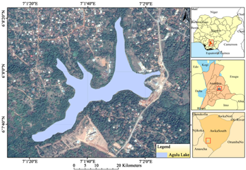
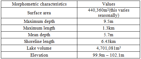
Agulu Lake is a natural inland lake characterized by the sacred and cultural landmark of attraction, and it is the largest lentic water body in Anambra state. It belongs to the Niger-Benue ichthyofaunal zone, which contains the commonest and best-known fishes 1 in Nigeria. Agulu Lake is located within latitudes 6°07' and 6°09'N and longitudes 7°01' and 7°03'E in Anambra State, Nigeria (Figure 1). The lake has an area of about 440361 m2 or 0.44 km2 and a depth that varies from 1.5m to 9.5m, with an average depth of 5.7m. The deepest part of the lake is 9.5m. The lake’s surface area has varied over time 2.
Anambra basin, within which Agulu lake lies, is dominantly filled with sediments of poorly consolidated sand units with a lithostratigraphic thickness of up to 2500m made up of Nkporo shale, Mamu formations, Ajalli sandstone, Nsukka formation, Imo shale, Nanka sands, Ameki formation, Nsugbe formation, and Ogwashi-Asaba formation 3. The study area is situated on the Awka-Orlu uplands, and the elevation of the terrain surrounding the lake varies from 300m to 600m. The area is characterized by a tropical wet and dry climate. The climate pattern which dominates Agulu Lake and its environs is controlled by the movement of the ITD and is characterized by a dry season (November to March) with dry continental North-East winds dominating during this period and a long-wet season which occurs normally from April to October and is dominated by the moist maritime south-west winds. The mean maximum and minimum temperatures within the study area and environs are 32.1°C and 23.5°C 4. The annual rainfall of the study area ranges from 1383mm to 2090mm 4 while the mean annual rainfall has varied from 1824mm to 1991.9mm, with relative humidity close to 80%. The rainfall regime is of double maxima, with the first peak occurring in July, followed by another peak in September. The lake is one of the headwaters of the Idemili River, which drains different communities in Anambra State before emptying into the River Niger. The high population density in the area and other human activities, including deforestation, urbanization, roadway construction, indiscriminate agricultural practice, and other forms of man-induced activities, have led to the loss of the primary forest 5. What exists now is secondary regrowth, or a forest savannah mosaic, where the oil palm is predominant, together with selectively reserved economic trees 6.
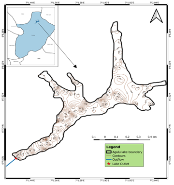
The bathymetric survey was conducted in Agulu Lake on July 29, 2021, using a South SDE Single Frequency Echo Sounder from the Department of Surveying and Geoinformatics at the University of Nigeria, Enugu Campus. The South SDE – 28S Echo Sounder operates at a single frequency of 200 kHz and has a maximum depth penetration range of 0.3 to 300 meters. The transducer was mounted on the survey boat, which collected depth data as it moved across the lake. The hydro-survey boat was a canoe equipped with a propeller engine. As the boat moved across the lake surface, depth soundings were collected and recorded at a ping rate of approximately 0.17 to 0.3 seconds by emitting sound pulses from the water surface to the lake bottom. The boat's maximum speed did not exceed 2–3 km/h 7. Additional equipment used included a Trimble GNSS receiver, a fish finder, a Pro XR GPS receiver with differential global positioning system (DGPS), and a 12V battery to power the instruments. The location and depth data were recorded by the built-in GPS, using World Geodetic System 1984 (WGS-84) as the datum 8. The collected depth soundings were used to generate a continuous bathymetric map via the open-source QGIS 3.14 software. Spatial interpolation of the soundings was performed using the Inverse Distance Weighted (IDW) method. IDW is a deterministic technique that estimates depths at unsampled points by a linear combination of known depths, weighted inversely by distance from the point of interest to the sampled locations 9. The bathymetric analysis facilitated the derivation of morphometric relationships between lake area and depth, depth and volume, and area and volume.
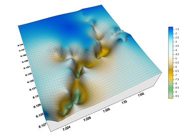
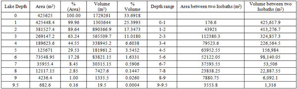
The bathymetric map of Agulu Lake and its 3D image, prepared for the first time in this study, are shown in Figure 2 and Figure 3, respectively. Table 1 presents a summary of the results of the lake depths measured by the acoustic echo sounding technique. The maximum-recorded depth is 9.5m. The depth increases from all directions towards the central part of the lake. From the bathymetric map, the northernmost area of the lake, towards the northeast, and down the eastern part of the lake had depth variations ranging from 1.5m to 5m. This area has the lowest depth values. The central part of the lake is the deepest, given the compact nature of the contour lines. The deepest part along the central part of the lake occurs on the northern shoreline, where the lake has a boundary with Nri town. The southern shoreline, the part bordering Agulu town, had slightly spaced contour lines indicating the gentle sloping of the lake on this part. More so, the central part of the lake had a combination of moderately spaced contours signifying gentle slopes and clustered contours indicating steep slopes. The depth variations along the central part of the lake, down to the southwest corner of the lake, range from 3 to 8m. A movement towards the southwest part of the lake, where the outlet is located, also showed variations ranging from 4.5 to 9m deep. Approaching the outlet, the depth of the lake continued to drop, varying from 6.5m to 1.2m. The surface area of the lake, as calculated from satellite imagery from 1978 to 2013 by 2, is 0.44km2. The observed reduction in the size of the lake has been linked to climate change and human activities around and within the lake 2. Both factors have influenced the area of the lake.
The summary of the bathymetric survey (Table 2) reveals that 99.96% of the lake area is about 1m deep, 89.64% is within 2m depth, 63.24% of the lake area is around 3m deep, 44.55% is about 4m deep, 29.53% is about 5m depth, 17.28% of the lake area is of 6m depth, 8.45% is 7m deep, 2.85% has a depth of 8m, 1% of the lake area is of 9m depth category while only 0.16% or 682m2 is within the 9.5m maximum depth. The area between specific depth ranges or depth intervals is shown in the column labelled area between isobaths. The largest area of the lake is within a 2-3m depth interval, which is 112,380.3m2 of the total lake area, which is 425,625m2 (0.46km2). The largest percentage of the lake volume (94.06%) is found between 0-4m depth. The largest part of the volume of the lake occurs within 0-1m depth, followed by 1-2m depth, totalling 3.03 x 10⁶m3 or 59.09% of the total volume.
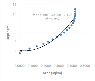
The graph of lake depth vs area for Agulu Lake was plotted and shown in Figure 3. A second-degree polynomial fit was done to derive the mathematical depth-area relationship 10. The graph of depth vs area relationship is the hypsographic curve of the lake, providing a visual representation and accurate information at a glance on how the area of Agulu Lake changes with depth. With this, it is relatively easy to see what the lake would look like if water levels were to shrink due to climate forcing or anthropogenic pressures. The bathymetric survey was sought to generate the necessary data to help establish the surface area–depth relationship of the lake. This relationship is depicted in Figure 4. This relationship yielded a second-degree polynomial equation with R2 of 0.9438 and is of the form:
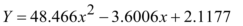 | (1) |
where, Y = lake depth and x = surface area
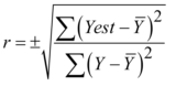
In addition, the non–linear correlation coefficients of the lake area and depth were obtained, given the non-linearity in their distribution. Thus, the suitable correlation between such distributions is described as the square root of the ratio between the explained variation and the total variation in a set of data X and Y 11. The non–linear correlation coefficient is defined as:
 | (2) |
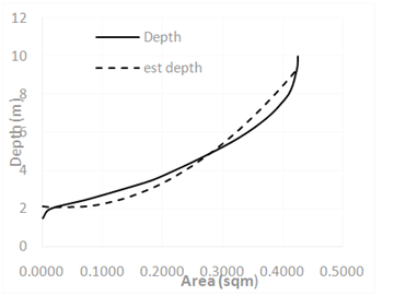
The correlation coefficient calculated using the equation is 0.9476. The curvilinear regression equation was also used to predict depth to assess the model's performance. Figure 5 displays the graph of predicted depth versus measured depth.
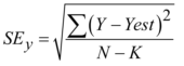
The standard error of the estimate was employed to measure how the second-degree polynomial equation fits the actual distribution of the measured depths and to determine the magnitude of error that may occur if the equation is used to estimate values of depth from surface area values. The standard error of estimate (SEy) was determined using the expression:
 | (3) |
where Y-Yest are the residuals and K is the number of coefficients in the polynomial equation, including the constant term.
The SEy value derived from the equation is 0.72. Thus, at a 95% level of confidence, if this equation is used to predict a value of lake depth, the true depth values will lie within the limits of 1.96± (0.72). The performance of this model was evaluated using the Nash–Sutcliffe Efficiency (NSE) ratio 12 given as follows:
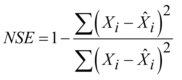 | (4) |
where, ,
, ,
,  are the measured depths of Agulu Lake, the predicted depths, and the mean of the measured data.
The theoretical range of NSE is from -∞ to 1, with NSE=1 being the optimal value. Values between 0.0 and 1.0 are generally viewed as acceptable levels of performance, whereas values less than 0.0 indicate that the mean observed value is a better predictor than the simulated value, which indicates unacceptable performance. The model assessment index derived using NSE is 0.95. Based on general performance ratings for recommended statistics 13, the model performed well, and the reconstructed depth of the lake was described well by the model.
The significance of the non–linear relationship between lake area and lake depth characteristics of Agulu Lake was tested by applying a Student’s t-test of the form:
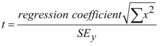 | (5) |
The hypothesis posited as “there is no significant relationship between lake area and lake depth characteristics of Agulu Lake” was tested. The calculated Student 't' yielded a value of t = 7.31. At a 0.05 level of confidence, the critical value of 't' is 1.74. Since the calculated ‘t’ value of 7.31 > 1.74, the H0 is rejected. Thus, there is a significant non–linear relationship between lake area and lake depth. Having ascertained the strength of the curvilinear regression model, this was used to estimate the yearly variations in the lake depth of Agulu Lake. In a preliminary study by 2, surface area variations of Agulu Lake were extracted from multi-temporal Landsat imagery from 1978 to 2013. The surface area variations of the lake were established to have been a consequence of variations in hydro-climatic variables like rainfall, temperature, and evaporation. The multiple regression models derived in the preliminary study 2 were further improved upon by the addition of the runoff component into the model. The multiple correlation analysis yielded a correlation coefficient of r = 0.77. This result is higher than that obtained by 2 (r = 0.685). The coefficient of multiple determination, R2, is given as R2 = 0.59. To determine the precise mathematical form of the relationship, a mathematical function was fitted to the sets of variables to predict values of surface area. The multiple relationships between surface area and hydro-climatological variables yielded an equation of the form:
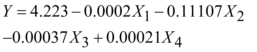 | (6) |
where, Y = surface area, X1 = Rainfall, X2 = Temperature, X3 = Evaporation and X4 = Runoff
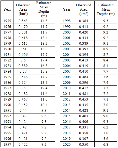
The model was used to predict the surface area of the lake for the period 1978 to 2013. The performance rating of the model yielded an NSE value of 0.65, indicating that the model is good for predicting surface area. Following the high rating of the model tested using Nash-Sutcliffe efficiency (NSE), the model was utilized to estimate the surface area of the lake, covering missing values within the study period, 1975–2020. Thus, the missing values of surface area were filled using the equation (Table 3).
The surface area values were input variables for estimating annual variations in lake depth using the second-degree polynomial equation, indicating the non–linear relationship between lake area and depth. Table 2 shows the values of the completed surface area of the lake and estimated depths, while Figure 6 shows the hypsographic curve of the annual surface area and predicted mean annual depth of Agulu Lake. Here, the model is clearly shown to be a good predictor of variations in lake depth for water resources planning and management, given the R2 value of 1. The mean annual surface area of the lake (1975 – 2020) is 0.447km2 while the mean annual estimated depth is 10.4m.
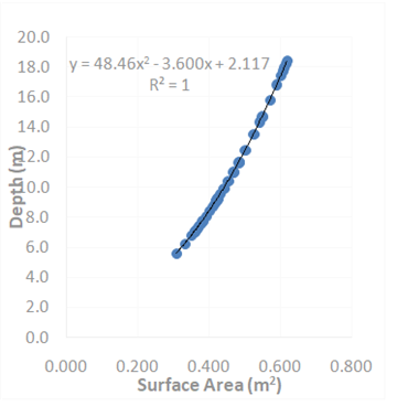
The graph depicts the strong morphometric relationship between surface area and depth. Given their strong positive relationship, thus, the decrease in surface area conditions of the lake is manifested in the variations and trends of the estimated average annual depth. This implies that, as the surface area decreases, the depth of the lake is reduced, and so is the volume of the lake.
3.2. Volume Vs DepthThe volume of the lake was determined at different contour levels during bathymetric sounding along with depth and area readings. The relationship between the volume and the depth of the lake is shown in Figure 7, and this has been fitted by a polynomial equation of the form given below with an R2 of 99.78%.
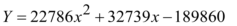 | (7) |
The curve clearly explains the established truth in volume-depth relations that volume increases or decreases as depth increases or decreases. More so, the bathymetric sounding made it possible to establish the actual volume of the lake. The actual volume of the lake determined here is the live storage component of the water balance equation. Thus, the computation of change in storage due to changing climatic forcing and anthropogenic impacts, such as water abstraction, can easily be deduced. The volume of the lake determined from bathymetric sounding is 4.701 x 10⁶ m3. No record of the previous volume for the lake is known.
The bathymetric analysis of Agulu Lake generated curves depicting depth-area-volume morphometric relationships, which indicate similar morphometric relationships to earlier observations made by 12, 13, 14 in parts of Africa. Previously, there was no available information on the Agulu lake area–depth relationship or the lake's area-depth-volume relationships, which are very important components for sustainable water resources planning, especially given the Anambra state government's consideration to exploit the lake for multiple water uses. Thus, the availability of these curves through this study would play a critical decision-making role for stakeholders in the water sector, the Ministry of Tourism, developing the Lake as a tourist site, and communities in managing water abstractions from Agulu Lake. In addition, the depth-area-volume relationships derived in this study through bathymetric analysis would be very useful for future work in determining the sedimentation rate and annual rates of storage capacity loss in the lake, as the present study has provided the needed baseline data on the lake depth, area, and volume. Clear benefits of the depth-area-volume relationship in computing the siltation rate of a lake in Nigeria were demonstrated in Lower Usuma Reservoir, Abuja, by 15 who utilized an acoustic echo sounding technique to illustrate that the dam has lost 8m depth to siltation in 28years of its operation, indicating a 17% loss in installed storage capacity. 16 employed depth-area-volume relationships derived from the bathymetric analysis in computing the number of trapped sediments over a given period by comparing the previous morphometric information for the Dokan Reservoir in Iraq with the new information obtained in their study. Similar benefits of analysing the depth-area-volume relationship were established by 14 in Lake Naivasha, Kenya, as a valuable tool for lake water management and a vital information source for lake water resources managers. Therefore, the baseline information provided in this paper is valuable for future comparative studies on the lake in determining potential changes in the lake as a result of environmental change, for ascertaining the lake's response of the lake's geometric variables to rainfall variations 13, and for proper management of the lake against excessive water abstraction.
The bathymetric map of Agulu Lake was generated for the first time in this study using the South SDE Acoustic Echo Sounder and analysed using QGIS 3.14 software. Surfer application was used to derive the 3D model of the lake. The lake was found to have a mean depth of 5.7m and a maximum depth of 9.5m, a volume of 4.701 x 10⁶m3, and a surface area of 425,625m2. Previous studies on the lake revealed the extent of the annual variations in the lake surface area and the relationship with changing climatic conditions. The present study provides valuable information for determining the lake depth/outflow relationship, being one of the headwaters of the Idemili River, which flows to the River Niger, for unlocking the full potential of the lake for sustainable water resources planning, and a basis for decision-making by stakeholders in the water sector concerning the economic activities within the lake catchment.
The authors appreciate the Agulu community for granting us access to the Agulu lake site and providing lifeguards. We are grateful to the Department of Surveying and Geoinformatics, University of Nigeria, for the South SDE Acoustic Echo Sounder used in this work.
This research work has not received any funding from any agency
The authors declare that there is no known conflict of interest, either financial or personal relationships that could have influenced the outcome of this research paper.
| [1] | Ukpaka, C. and Akunne, C. (2013). "Identification of Fish fauna of Agulu lake, Agulu, Anambra State," Inter. J. AgriBiosci, vol. 2, no. 5, p. 248. | ||
| In article | |||
| [2] | Nzoiwu, C.P., Ezenwaji, E.E., and Okoye, A.C. (2017). "A Preliminary Assessment of the Effects of Climate Variability on Agulu Lake, Anambra State, Nigeria," American Journal of Climate Change, vol. 6, no. 4, pp. 694-710. | ||
| In article | View Article | ||
| [3] | Egboka, B. C. E., Nfor, B. N., and Banlanjo, E. W. (2006). "Water Budget Analysis of Agulu Lake in Anambra State, Nigeria," J. Appl. Sci. Environ. Mgt, vol. 10, no. 3, pp. 27-30. | ||
| In article | View Article | ||
| [4] | Nzoiwu, C. P. and Ezenwaji, E. E. (2017). "Contributions of Anthropogenic Factor to the Observed Surface Area Variation of Agulu Lake, Anambra State," J. Geogr., Meteorol. and Env. (JGME), vol. 2, no. 1, pp. 38-45. | ||
| In article | |||
| [5] | Okoyeh, E. I., Akpan, A. E., Egboka, B. C. E., and Okeke, H. I. (2014). "An assessment of the influences of surface and subsurface water level dynamics in the development of Gullies in Anambra State, Southeastern Nigeria," Earth Interactions, vol. 18, pp. 1-24. | ||
| In article | View Article | ||
| [6] | Nwakanma Christian C., Emmanuel Chigozie Dike, Dimkpa K., and Andrew A. Obafemi (2018). "Spatial monitoring of the extent of gully erosion in Agulu-Nanka and its Environs in Anambra State using Geo-information Technologies," International Journal | ||
| In article | |||
| [7] | Borowiak, D., Nowiński, K., and Katarzyna Grabowska (2016). "A new bathymetric survey of the Suwałki Landscape Park lakes," Limnol. Rev., vol. 16, no. 4, p. 185–197. | ||
| In article | View Article | ||
| [8] | De Maisonneuve, C. B., Eisele, S., Forni, F., Hamdi, Park, E, Phua, M, and Putra, R. (2019). "Bathymetric survey of lakes Maninjau and Diatas (West Sumatra), and lake Kerinci (Jambi)," IOP Conf. Series: Journal of Physics, 2019. | ||
| In article | View Article | ||
| [9] | Li J and Heap A.D. (2008). A Review of Spatial Interpolation Methods for Environmental Scientists. , Canberra, Australia.: Geoscience Australia. | ||
| In article | |||
| [10] | Legesse, D., Vallet-Coulomb, C. and Gasse, F. (2004). Analysis of the hydrological response of a tropical terminal lake, Lake Abiyata (Main Ethiopian Rift Valley) to changes in climate and human activities, Hydrol. Process. (18) 487 – 504. | ||
| In article | View Article | ||
| [11] | Moriasi D.N., Arnold J.G., Van M.W., Bingner R.L, Veith T.L. (2007). "Model evaluation guidelines for systematic quantification in watershed simulations," Transactions of the ASABE, vol. 50, no. 3, pp. 885-900. | ||
| In article | View Article | ||
| [12] | Kumamabala, P.G. and Ervine, A. (2010). "Water balance model of lake Malawi and its sensitivity to climate change," The open hydrology journal, vol. 4, pp. 152-162. | ||
| In article | View Article | ||
| [13] | Kebede, S., Travi, Y.; Alemayehu, T. and Marc, V. (2006). "Water balance of Lake Tana and its sensitivity to fluctuations in rainfall, Blue Nile Basin, Ethiopia," J. Hydrol, vol. 316, p. 233–247. | ||
| In article | View Article | ||
| [14] | Maina C.W., Sang J.K., Mutua B.M., and Raude J.M. (2017). "Bathymetric survey of Lake Naivasha and its satellite Lake Oloiden in Kenya; using acoustic profiling system," Lakes and Reserv., vol. 23, pp. 324-332. | ||
| In article | View Article | ||
| [15] | R. (2017). "An assessment of bathymetric changes in the Lower Usuma Reservoir, Abuja Nigeria," Nigerian Journal of Hydrological Sciences, vol. 5, pp. 52-61. | ||
| In article | |||
| [16] | Hassan R., Al-Ansari N., Ali A.A, Ali S.S. and Knutsson S. (2017). "Bathymetry and Siltation rate for Dokan Reservoir, Iraq," Lakes and Reservoirs: Research and Management, vol. 22, no. 2, p. 179 – 189. | ||
| In article | View Article | ||
Published with license by Science and Education Publishing, Copyright © 2025 Nzoiwu Chukwudi P., Ozoemene Mmaduka L., Ezeonyejiaku Chigozie D., Igboanugo Chidera P., Obikwelu Michael. C. and Igboanugo Ifunanya R.
![]() This work is licensed under a Creative Commons Attribution 4.0 International License. To view a copy of this license, visit
http://creativecommons.org/licenses/by/4.0/
This work is licensed under a Creative Commons Attribution 4.0 International License. To view a copy of this license, visit
http://creativecommons.org/licenses/by/4.0/
| [1] | Ukpaka, C. and Akunne, C. (2013). "Identification of Fish fauna of Agulu lake, Agulu, Anambra State," Inter. J. AgriBiosci, vol. 2, no. 5, p. 248. | ||
| In article | |||
| [2] | Nzoiwu, C.P., Ezenwaji, E.E., and Okoye, A.C. (2017). "A Preliminary Assessment of the Effects of Climate Variability on Agulu Lake, Anambra State, Nigeria," American Journal of Climate Change, vol. 6, no. 4, pp. 694-710. | ||
| In article | View Article | ||
| [3] | Egboka, B. C. E., Nfor, B. N., and Banlanjo, E. W. (2006). "Water Budget Analysis of Agulu Lake in Anambra State, Nigeria," J. Appl. Sci. Environ. Mgt, vol. 10, no. 3, pp. 27-30. | ||
| In article | View Article | ||
| [4] | Nzoiwu, C. P. and Ezenwaji, E. E. (2017). "Contributions of Anthropogenic Factor to the Observed Surface Area Variation of Agulu Lake, Anambra State," J. Geogr., Meteorol. and Env. (JGME), vol. 2, no. 1, pp. 38-45. | ||
| In article | |||
| [5] | Okoyeh, E. I., Akpan, A. E., Egboka, B. C. E., and Okeke, H. I. (2014). "An assessment of the influences of surface and subsurface water level dynamics in the development of Gullies in Anambra State, Southeastern Nigeria," Earth Interactions, vol. 18, pp. 1-24. | ||
| In article | View Article | ||
| [6] | Nwakanma Christian C., Emmanuel Chigozie Dike, Dimkpa K., and Andrew A. Obafemi (2018). "Spatial monitoring of the extent of gully erosion in Agulu-Nanka and its Environs in Anambra State using Geo-information Technologies," International Journal | ||
| In article | |||
| [7] | Borowiak, D., Nowiński, K., and Katarzyna Grabowska (2016). "A new bathymetric survey of the Suwałki Landscape Park lakes," Limnol. Rev., vol. 16, no. 4, p. 185–197. | ||
| In article | View Article | ||
| [8] | De Maisonneuve, C. B., Eisele, S., Forni, F., Hamdi, Park, E, Phua, M, and Putra, R. (2019). "Bathymetric survey of lakes Maninjau and Diatas (West Sumatra), and lake Kerinci (Jambi)," IOP Conf. Series: Journal of Physics, 2019. | ||
| In article | View Article | ||
| [9] | Li J and Heap A.D. (2008). A Review of Spatial Interpolation Methods for Environmental Scientists. , Canberra, Australia.: Geoscience Australia. | ||
| In article | |||
| [10] | Legesse, D., Vallet-Coulomb, C. and Gasse, F. (2004). Analysis of the hydrological response of a tropical terminal lake, Lake Abiyata (Main Ethiopian Rift Valley) to changes in climate and human activities, Hydrol. Process. (18) 487 – 504. | ||
| In article | View Article | ||
| [11] | Moriasi D.N., Arnold J.G., Van M.W., Bingner R.L, Veith T.L. (2007). "Model evaluation guidelines for systematic quantification in watershed simulations," Transactions of the ASABE, vol. 50, no. 3, pp. 885-900. | ||
| In article | View Article | ||
| [12] | Kumamabala, P.G. and Ervine, A. (2010). "Water balance model of lake Malawi and its sensitivity to climate change," The open hydrology journal, vol. 4, pp. 152-162. | ||
| In article | View Article | ||
| [13] | Kebede, S., Travi, Y.; Alemayehu, T. and Marc, V. (2006). "Water balance of Lake Tana and its sensitivity to fluctuations in rainfall, Blue Nile Basin, Ethiopia," J. Hydrol, vol. 316, p. 233–247. | ||
| In article | View Article | ||
| [14] | Maina C.W., Sang J.K., Mutua B.M., and Raude J.M. (2017). "Bathymetric survey of Lake Naivasha and its satellite Lake Oloiden in Kenya; using acoustic profiling system," Lakes and Reserv., vol. 23, pp. 324-332. | ||
| In article | View Article | ||
| [15] | R. (2017). "An assessment of bathymetric changes in the Lower Usuma Reservoir, Abuja Nigeria," Nigerian Journal of Hydrological Sciences, vol. 5, pp. 52-61. | ||
| In article | |||
| [16] | Hassan R., Al-Ansari N., Ali A.A, Ali S.S. and Knutsson S. (2017). "Bathymetry and Siltation rate for Dokan Reservoir, Iraq," Lakes and Reservoirs: Research and Management, vol. 22, no. 2, p. 179 – 189. | ||
| In article | View Article | ||


