The paucity of spatially representative sub-daily rainfall data in Nigeria has caused difficulty in the determination of design rainfall necessary for event-based flood modelling. Previous work on the development of Intensity-Duration-Frequency (IDF) curves for Nigeria was done in the 1980s based on historical rainfall data between 1948-1978 at 35 locations in the country (referred to as Federal Ministry of Works-IDF: FMW-IDF); however, extensive application of these IDF curves has been hampered by the vagaries of climate change. Taking advantage of current technological advancements in remote sensing for rainfall estimation, the Tropical Rainfall Measuring Mission (TRMM) Satellite-based estimates was selected amongst four other rainfall products for developing the updated IDF curves. Results indicate that the TRMM product can successfully be applied to develop more spatially representative IDF curves for Nigeria. This work hereby provides 72 locations nationwide with relevant parameters to readily compute rainfall intensity values for the 2yr, 5yr, 10yr, 25yr, 50yr, and 100yr return periods, this carries overarching implications for urban flood design and management in the Country.
The lack of discharge data at most locations of interest for the design of stormwater drainage systems, dams, bridges, and flood management studies, has necessitated the transformation of more readily available rainfall data to design flow using hydrological models. For event-based models, the hypothetical rainfall value or hyetograph is referred to as the design rainfall or design storm 1.
The design storm selection is based on a relationship between the rainfall depth/intensity, duration, and the frequency or return period appropriate for the facility to be designed or studied. Frequency analysis in hydrology is used to correlate the magnitude of extreme events to their frequency of occurrence using probability distributions 1. To further facilitate rigorous frequency analysis, sufficiently long time series data for the selected location is required, there is however a general paucity of rainfall data at the required temporal resolution for most locations in Africa due to capital, technical, and managerial issues, especially in Nigeria.
The spatial coverage of meteorological stations in Nigeria is currently inadequate and falls far below the requirements of the World Meteorological Organization 2. From the beginning of 1900s, the number of rain gauges in the country increased from 11 to 368 in the year 1992, representing a gauge density of one per 2,500 km2 3; these gauges were maintained by the Federal Department of Meteorological Services (FDMS), now Nigerian Meteorological Services Agency (NIMET), and some agricultural institutions. Currently, most of the gauging stations have become moribund and data collection has been reduced to few synoptic stations (less than 100) managed by NIMET; this has significantly reduced the required gauge density. Sub-daily rainfall data required for generation of design storms for urban drainage design are rarely collected. Thus, the estimation of design rainfall intensity across the country is difficult and prone to errors.
Majority of reputable studies on the development of rainfall intensity-duration-frequency (IDF) relationships for Nigeria were based on daily rainfall records 4, 5, 6, the only study that employed “short duration rainfall records” was by 7, 8. Reference 8 (1983) obtained rainfall data from 35 recording stations for the period 1948 to 1978 and generated IDF curves for each location using the Method of Maximum Likelihood estimation and fitted using the Gumbel (EV-I) distribution. Considering that the length of records used varied from 5yrs to 30yrs with 18 stations exceeding 20yrs and only 3 exceeding 25yrs, Reference 7 (1982) employed a regionalization approach by dividing the country into 10 zones based on climatic and topographic characteristics thereby increasing the records length per region to between 20yrs and 115yrs. IDF parameters were computed by fitting the Gumbel (EV-I) distribution to the annual maximum series for each duration. The result obtained from 7, 8 were adopted in the latest edition of the Nigeria Highway Manual 9.
Scientists have however developed methods of rainfall data estimation using remote sensing via satellite, and Geographic Information Systems (GIS) interpolation techniques 4, 5, 10, 11, 12. Satellite rainfall datasets are available in geographic gridded (raster) formats which provide sufficient spatial coverage for most engineering design requirements so far as the datasets are calibrated and verified using in-situ gauge measurement. Against this backdrop, this work therefore focuses on the determination of intensity-duration-frequency (IDF) relationships using sub-daily satellite rainfall estimates.
Nigeria is located within the western sub-region of Africa. It shares international borders with Benin (West), Cameroun (East), Niger (North), Chad (North East) and to the South by the Atlantic Ocean with about 850km of coastline. It has a total land surface area of approximately 920,000 km2 and is bounded by Latitudes 4° 16' 20.3" N and 13° 53' 40.6" N, and Longitudes 2° 40' 09.7" E and 14° 40' 46.0" E (Figure 1).
The climate is influenced mainly by rainfall that varies in latitude from humid in the southern coastal zone which receives high rainfall over 2,500 mm, and declines progressively towards the semi-arid northern regions with low rainfall below 500 mm. The local weather consists of distinct dry and wet seasons, the onset of rainfall defines the wet (rainy or monsoon) season and it begins when the rain-belt (zone of maximum rainfall) traverses the southern region in the month of March or April and proceeds to the middle zone by April or May and finally reaches the northern zone in May or June. The peak of the rainy season usually occurs in the month of August for the Middle/Northern zones while the rain ceases by October. The southern parts however experience a double peak (in the months of July and September) separated by a trough in the month of August termed “the August break”. The rain-belt eventually recedes towards the equator by late November.
The generation mechanism and seasonal occurrence of rainfall in the tropics follows the movement of the earth around the sun and consequent insolation and heating of the Earth surface along the equator which induces a low pressure zone wherein the trade-winds converge and rise vertically due to convection into the upper troposphere (Hadley cells). Over West Africa, the moisture laden Tropical Maritime (TM) air mass which comes over the Atlantic Ocean from the south meets with the dry and dust laden Tropical Continental (TC) air mass which originates from the north-east over Sahara Desert 13. This low pressure region wherein the TM and TC converge and rise is aptly called the Inter-Tropical Convergence Zone (ITCZ).
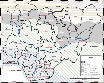
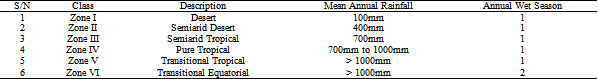
The subdivision of Nigeria into climatic zones is based on one or more combinations of geographic and climatic variables. It is necessary at this point to distinguish strict climatic subdivisions from other classifications that include biome and agriculture, these are appropriately named as ecological, eco-climatic, agro-climatic, bioclimatic, agro-ecological, or vegetation zones. Reference 13 reported six zones for hydrological studies in West African and implemented by 14 using the Tropical Rainfall Measuring Mission (TRMM) daily rainfall data for 1998-2014. The climatic subdivisions include six zones (Figure 1) which are based on mean annual and seasonal rainfall as defined in Table 1. Thus, Nigeria is covered majorly by four zones: Zone III (semiarid tropical), Zone IV (pure tropical), Zone V (transitional tropical), and the Zone VI (transitional equatorial); with a northern fringe of Zone II (semiarid desert).
2.2. Satellite Rainfall Data ValidationThe prohibitive cost of maintaining a dense network of in-situ gauges or radar installations necessitates the recourse to satellites as a practical means of large area or global scale rainfall monitoring. Considering also that satellite measurement are indirect and special algorithms are required to correlate the measured attributes to actual rainfall rates, the application of Satellite-based Rainfall Estimates (SRE) in hydrology and engineering requires validation vis-a-vis in-situ measurements 15.
Several studies on the performance evaluation of SRE with respect to ground-based gauge rainfall at varying temporal accumulations (daily, monthly, seasonal, annual) have been carried out with promising results within Nigeria 12, 16, 17, 18, 19, Africa [20-39], and other continents [40-61]. For the purpose of SRE applications in extreme frequency analysis and computation of IDF parameters however, and based on current knowledge available during this work, no study has been done in Nigeria. Only two have been conducted in Africa for Angola 62 and Ghana 63, and some in other parts of the world [64-77].
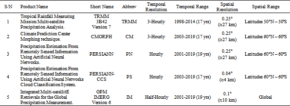
Five (5) satellite rainfall products were selected based on criteria of spatial resolution (national coverage), temporal resolution (sub-daily records), and sufficiently long time series (greater than 15 years of records); more especially, all the selected satellite rainfall products are available free of charge.
The products include:
a) Tropical Rainfall Measuring Mission Multi-satellite Precipitation Analysis (TRMM) 78.
b) Climate Prediction Centre Morphing technique (CMORPH) 79.
c) Precipitation Estimation From Remotely Sensed Information Using Artificial Neural Networks (PERSIANN) 80.
d) Precipitation Estimation From Remotely Sensed Information Using Artificial Neural Networks Cloud Classification System (PERSIANN CCS) 80.
e) Integrated Multi-satellite Retrievals for the Global Precipitation Measurement (GPM IMERG) 81.
Table 2 contains a summary of each SRE product, a comprehensive review of the satellite rainfall structure and estimation algorithms is beyond the scope of this work, more information is available at the aforementioned references and thus the details will not be repeated in this paper. It is however worthy of note that according to 82 the TRMM satellite ran out of fuel in July 2014 and commenced descent until it fell back to earth on 17th June 2015, users have been advised that “projects that require the best homogeneity only use 3B42 for the period January 1998 to September 2014”, hence only this period has been considered for use in this study.
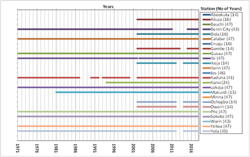
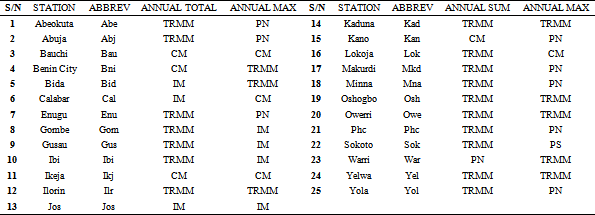
Extraction of the SRE time series for validation at each rain gauge location (Figure 2) was done using a “Point to Pixel” approach whereby the coordinates of each ground gauge coincident with the SRE grid cell was used to extract the time series. Figure 3 shows the gauge data availability chart for the 25 ground stations which span a period of 1971 to 2017, data validation was performed between the respective SRE annual values that coincide with the gauge data.
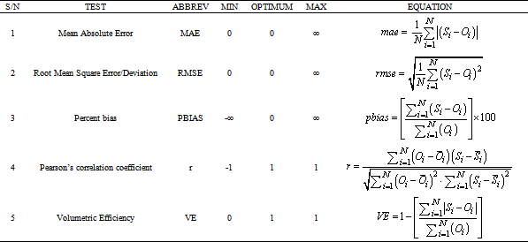
Five validation metrics (Table 3) were adopted to compare the five SRE with in-situ rain gauge data to facilitate the selection of the most appropriate satellite product. Two validation categories were considered for each satellite product (total annual rainfall, and annual maximum daily rainfall); the product that performed well persistently out of the five validation metrics was selected for each station and the final SRE to be chosen will be the best performing for both validation categories.
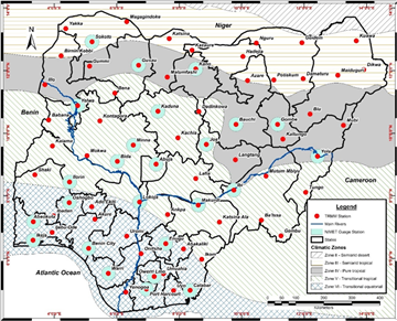
After selection of the candidate SRE, a GIS based extraction of the gridded raster datasets at the 25 daily rain gauge stations (Figure 2) maintained by Nigeria meteorological Agency (NIMET) and an additional 45 locations at major cities around the country (72 locations in total) was undertaken. Based on the works of 83 data extraction of the annual maximum rainfall series was done using a 25 km buffer around the respective station coordinates, this is to guard against a situation whereby a grid cell with higher rainfall intensity than the gauge point location is present in the vicinity, thereby underestimating the extreme value.
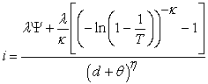
The IDF analysis involved fitting the annual extreme data (for each duration) to a probability distribution 7, 84, 85, 86. According to 84, IDF formulae can be generalized in the form of the equation 1.
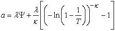
 | (1) |
This depicts the intensity, i (mm/hr) as a separate function of the return period, T (year) and duration, d (hr). The term 
 , is directly proportional to the return period and can be theoretically determined based on the inverse function of the statistical distribution used to fit the annual extreme values. It suffices to note that:
 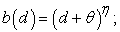 where θ, and η are parameters (θ > 0, 0 < η < 1) which vary with location only.
By substituting into equation 1, the general form becomes
 | (2) |
In view of the documented superiority of the three-parameter Fréchet (extreme value type II distribution–EV2) over the two-parameter Gumbel (extreme value type I-EV1) distribution 87, 88, 89, the EV2 distribution was used for fitting the annual extreme values, thus:
 | (3) |
where  is the dimensionless location parameter,
  is the scale parameter in mm/hr
  and
and  is the dimensionless shape parameter
  Substituting into equation (2) gives the final IDF formula shown in equation (4).
 | (4) |
For each location, parameter estimation for equation (4) was done using the two-step procedure described in 84. Initially, parameters  and
and  were determined using the trial and error method of minimization of the Kruskal-Wallis statistic. As a consequence, parameters
 and
and  were computed using the more robust L-moments method 90. Based on the tendency of the
  parameter to approach negative values due to small record lengths, the value of 0.114 was used as proposed in 91.
Parameter estimation using a point/location based approach was favoured over the regional approach because of the sufficient spatial coverage characteristic of the SRE datasets and also considering the observed rain gauge and IDF datasets to be used for validation are point based. The essence of regionalization is to capture ungauged sites and also reduce computational rigour, however, the development of Isopleths for the IDF parameters will assist in parameter estimation for ungauged areas outside the point locations. The IDF curves for 29 stations in Nigeria based on the SRE dataset were compared with the IDF curves reported in 9. For objectivity, percentage error was also computed for each duration and return period.
Results of the validation exercise are summarized in Table 4. For the annual total category, the TRMM 3B42 Version 7 data performed overwhelmingly with 17 out of the 25 stations, with CMORPH being the next contender with just 4 stations. For the annual daily maximum category there is a tie between TRMM 3B42 Version 7 and PERSIANN data with both performing at 8 stations each, CMORPH and GPM IMERG are runner ups with 4 stations each. TRMM 3B42 Version 7 was selected as the final candidate SRE considering that it performs the best of the two final candidates for both categories.
3.2. Data Extraction and EV2 ParametersConsidering that the TRMM datasets come in 3hr intervals, the first step is to aggregate the data over 6hr, 12hr, and 24hr durations, then maximum values were extracted using a block maxima approach which employs a moving (sliding) annual window corresponding to the relevant duration. Annual maximum values for accumulated durations of 3, 6, 12, and 24 were computed for 17 years of TRMM annual maximum rainfall series (1998 to 2014) at the 72 locations. The depths were divided by the corresponding durations to obtain the average intensity values.
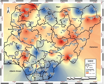
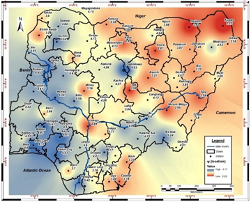
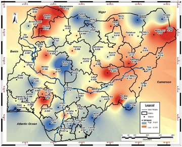
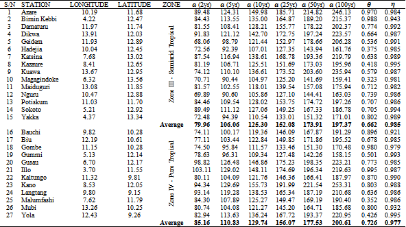
The parameters of the EV2 distribution vary with stations. Figure 4 to Figure 9 show the spatial variation of the L-Moments (L1, L2, and L3), and the three EV2 parameters (
 and
and  ). The location parameter,
  displays no specific zonal variation, rather there is a North-West to South-Eastern gradient from high to low values, with a maximum of 6.17 at Ijebu Ode (Zone VI), minimum of 2.22 at Kuawa (Zone III), and a national average of 4.17. The scale parameter,
  however, displays a variation in the opposite direction (South-East to North-Western) with maximum of 34.51 at Lokoja (Zone V), minimum of 11.77 at Dadinkowa (Zone V) and average of 20.50. The dimensionless shape parameter,
  shows no defined spatially variation; it ranges from 0.643 at Minna (Zone V) to -0.440 at Dikwa (Zone III), with a national average of -0.026. Values of
  cannot be considered in the analysis of maximum rainfall intensities because it implies an upper bound of the parameter 84, hence the value of 0.114 as recommended by 87 was adopted.

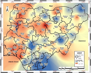

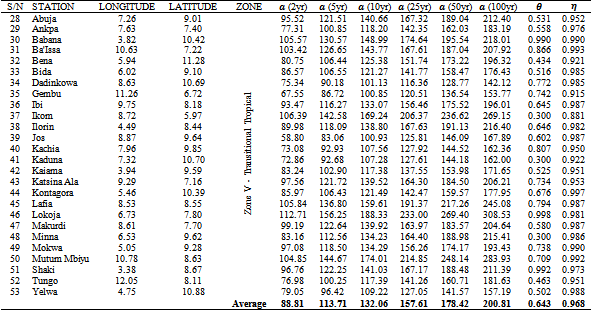
The parameters ( and
and  ) of the IDF curves based on TRMM dataset (TRMM-IDF) are presented in Table 5 to Table 7. The parameter,
  , varies with location and return period, showing a directly proportional increase in value with increase in return period; and also an average zonal increase from higher to lower latitudes. There is no discernible pattern in the zonal variation of
  the maximum value of the parameter is 0.998 in Lokoja (Zone V) and minimum of 0.3 in Minna (Zone V), and Ibadan (Zone VI). The
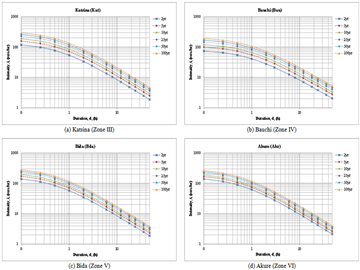
  parameter however shows overwhelmingly high values in Zones III, IV, and V, and low values in Zone VI. A maximum of 0.997 occurs in Kontagora (Zone V), and minimum of 0.856 in Ikeja (Zone VI). Sample IDF curves for selected stations are presented in Figure 10.
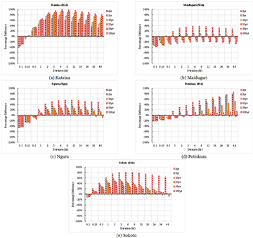
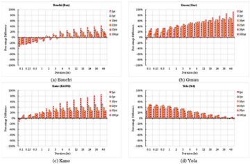
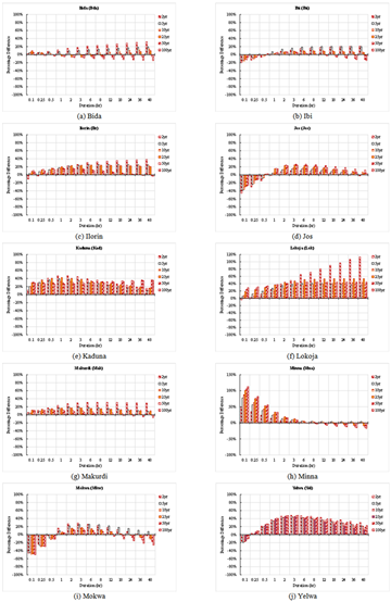
Figure 11 displays the 29 coincident 9 IDF locations amongst the 72 TRMM-IDF locations. Figure 12 to Figure 15 illustrate results of the zonal comparisons between the TRMM and the Reference 9 IDF values. The percentage difference (PBIAS) between the intensities for each duration and corresponding return period is clearly visualized, with positive values indicating higher TRMM relative to 9 and negative values indicating otherwise.
a) In Zone III (Semiarid Tropical), which comprises five stations (Katsina, Maiduguri, Nguru, Potiskum, and Sokoto), there is a general tendency for underestimation below and over overestimation beyond the 1-hour duration for all return periods. With maximum deviation of 99.36% for the 6hr duration-50yr return period at Katsina, and minimum deviation of -46.68% at the 0.1hr duration-2yr return period at Nguru.
b) Zone IV (Pure Tropical) includes four stations (Bauchi, Gusau, Kano, and Yola) with maximum deviation of 92.36% for the 48hr duration-100yr return period in Gusau, and minimum deviation of -33.04% at the 0.1hr duration-2yr return period in Bauchi.
c) Zone V (Transitional Tropical) consists of ten stations (Bida, Ibi, Ilorin, Jos, Kaduna, Lokoja, Makurdi, Minna, Mokwa, and Yelwa) with a maximum deviation of 113.40% for the 48hr duration-2yr return period in Lokoja, and minimum deviation of -50.23% at the 0.1hr duration-100yr return period in Mokwa.
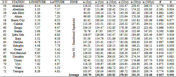
d) Zone VI (Transitional Equatorial) contains ten stations (Akure, Benin City, Calabar, Enugu, Ibadan, Ikeja, Oshogbo, Port Harcourt, Umuahia, and Warri) with a maximum deviation of 86.33% for the 48hr duration-5yr return period in Umahia, and minimum deviation of -47.23% at the 0.1hr duration-2yr return period in Benin City.
The greatest deviations in intensity values between TRMM-IDF and the 9 can be observed in Zone V corresponding to Lokoja (113.40%) at the 48hr duration-2yr return period, and Mokwa (-50.23%) at the 0.1hr duration-100yr return period. It is worthy of note that factors such as data source, number of data years, temporal resolution, and climate change play an important role in the disparities between both datasets which cannot readily be quantified.

This work has demonstrated the use of satellite rainfall estimates, specifically the TRMM dataset for development of IDF data for Nigeria. Spatial variations are evident in the parameters of the IDF curves, the magnitude of these variations cannot be said to be physically deterministic but rather stochastic whose determination is difficult due to the lack of adequate spatially representative sub-daily gauge rainfall data in the country. The comparison between the TRMM-IDF output and existing 9 curves show a maximum percentage difference (positive and negative) of approximately 100% across all durations and return periods considered, with the TRMM-IDF intensity values exceeding 9 IDF values in most of the locations. In the face of climate change effects being experienced globally, the adoption of the TRMM-IDF should be considered for nationwide drainage infrastructure design and flood management projects.
| [1] | Chow, V.T., Maidment, D.R., and Mays, L.W. (1988) Applied hydrology. McGraw-Hill, Inc. | ||
| In article | |||
| [2] | WMO (2008) Guide to Hydrological Practices: Hydrology - From Measurement to Hydrological Information. Sixth Edition World Meteorological Organization. | ||
| In article | |||
| [3] | Mott-MacDonald (1992) Sub-Saharan Africa Hydrological Assessment. West African Countries. Country report : Nigeria. The World Bank, United Nations Development Programme, African Development Bank. | ||
| In article | |||
| [4] | Bilewu, S. and Sule, B. (2015) Selection of an Appropriate Interpolation Method for Rainfall Data In Central Nigeria. Ethiopian Journal Environmental Studies Management. 8 (4), 423-432. | ||
| In article | View Article | ||
| [5] | Okoro, U.K., Chen, W., Chineke, C., and Nwofor, O. (2014) Comparative analysis of gridded datasets and gauge measurements of rainfall in the Niger Delta region. Research Journal Environmental Sciences. 8 (7), 373. | ||
| In article | View Article | ||
| [6] | Ologhadien, I. and Nwaogazie, I. (2017) Comparative analysis of rainfall IDF equation types for predicting rainfall intensity in Southern Nigeria. Nigerian Journal Technology. 36 (4), 1296-1302. | ||
| In article | View Article | ||
| [7] | Oyebande, L. (1982) Deriving rainfall intensity-duration-frequency relationships and estimates for regions with inadequate data. Hydrological Sciences Journal. 27 (3), 353-367. | ||
| In article | View Article | ||
| [8] | Oyebande, L. (1983) Rainfall Intensity, Duration, Frequency Curves and Maps for Nigeria. Department of Geography, University of Lagos. | ||
| In article | |||
| [9] | FMW (2013) Nigerian Highway Manual Part 1: Design. Second Edition Federal Ministry of Works. | ||
| In article | |||
| [10] | Mohymont, B., Demarée, G., and Faka, D. (2004) Establishment of IDF-curves for precipitation in the tropical area of Central Africa-comparison of techniques and results. Natural Hazards Earth System Science. 4 (3), 375-387. | ||
| In article | View Article | ||
| [11] | Novella, N.S. and Thiaw, W.M. (2013) African rainfall climatology version 2 for famine early warning systems. Journal Applied Meteorology Climatology. 52 (3), 588-606. | ||
| In article | View Article | ||
| [12] | Abiola, S.F., Mohd-Mokhtar, R., Ismail, W., Mohamad, N., and others (2013) Categorical statistical approach to satellite retrieved rainfall data analysis in Nigeria. Scientific Research Essays. 8 (43), 2123-2137. | ||
| In article | View Article | ||
| [13] | L’Hote, Y., Dubreuil, P., and Lerique, J. (1996) Map of climate types in “Africa west of the River Congo”. Recalling and extending the use of hydrological regimes. | ||
| In article | |||
| [14] | ECREEE (2017) GIS Hydropower Resource Mapping and Climate Change Scenarios for the ECOWAS Region - Technical Report on Methodology and Lessons Learnt for ECOWAS Countries. ECOWAS Centre for Renewable Energy and Energy Efficiency (ECREEE). | ||
| In article | |||
| [15] | Bell, T.L. and Kundu, P.K. (2003) Comparing satellite rainfall estimates with rain gauge data: Optimal strategies suggested by a spectral model. Journal Geophysical Research: Atmospheres. 108 (D3). | ||
| In article | View Article | ||
| [16] | Ogbu, K.N., Houngue, N.R., Gbode, I.E., and Tischbein, B. (2020) Performance Evaluation of Satellite-Based Rainfall Products over Nigeria. Climate. 8 (10). | ||
| In article | View Article | ||
| [17] | Akinyemi, D.F., Ayanlade, O.S., Nwaezeigwe, J.O., and Ayanlade, A. (2019) A comparison of the accuracy of multi-satellite precipitation estimation and ground meteorological records over Southwestern Nigeria. Remote Sensing Earth Systems Sciences. 1-12. | ||
| In article | View Article | ||
| [18] | Nwachukwu, P.N., Satge, F., Yacoubi, S.E., Pinel, S., and Bonnet, M.-P. (2020) From TRMM to GPM: How Reliable Are Satellite-Based Precipitation Data across Nigeria? Remote Sensing. 12 (23), 3964. | ||
| In article | View Article | ||
| [19] | Usman, M., Nichol, J.E., Ibrahim, A.T., and Buba, L.F. (2018) A spatio-temporal analysis of trends in rainfall from long term satellite rainfall products in the Sudano Sahelian zone of Nigeria. Agricultural Forest Meteorology. 260 273-286. | ||
| In article | View Article | ||
| [20] | Akinsanola, A.A., Ogunjobi, K.O., Ajayi, V.O., Adefisan, E.A., Omotosho, J.A., and Sanogo, S. (2017) Comparison of five gridded precipitation products at climatological scales over West Africa. Meteorology Atmospheric Physics. 129 (6), 669. | ||
| In article | View Article | ||
| [21] | Bodian, A., Dezetter, A., Deme, A., and Diop, L. (2016) Hydrological evaluation of TRMM rainfall over the upper Senegal river basin. Hydrology. 3 (2), 15. | ||
| In article | View Article | ||
| [22] | Adeyewa, Z.D. and Nakamura, K. (2003) Validation of TRMM radar rainfall data over major climatic regions in Africa. Journal Applied Meteorology. 42 (2), 331-347. | ||
| In article | View Article | ||
| [23] | Adjei, K.A., Ren, L., Appiah-Adjei, E.K., Kankam-Yeboah, K., and Agyapong, A.A. (2012) Validation of TRMM data in the Black Volta Basin of Ghana. Journal Hydrologic Engineering. 17 (5), 647-654. | ||
| In article | View Article | ||
| [24] | Ayehu, G.T., Tadesse, T., Gessesse, B., and Dinku, T. (2018) Validation of new satellite rainfall products over the Upper Blue Nile Basin, Ethiopia. Atmospheric Measurement Techniques. 11 (4), 1921-1936. | ||
| In article | View Article | ||
| [25] | Bayissa, Y., Tadesse, T., Demisse, G., and Shiferaw, A. (2017) Evaluation of satellite-based rainfall estimates and application to monitor meteorological drought for the Upper Blue Nile Basin, Ethiopia. Remote Sensing. 9 (7), 669. | ||
| In article | View Article | ||
| [26] | Belayneh, A., Sintayehu, G., Gedam, K., and Muluken, T. (2020) Evaluation of satellite precipitation products using HEC-HMS model. Modeling Earth Systems Environment. 6 (4), 2015-2032. | ||
| In article | View Article | ||
| [27] | Casse, C., Gosset, M., Peugeot, C., Pedinotti, V., Boone, A., Tanimoun, B., et al. (2015) Potential of satellite rainfall products to predict Niger River flood events in Niamey. Atmospheric Research. 163 162-176. | ||
| In article | View Article | ||
| [28] | Le Coz, C. and Van De Giesen, N. (2020) Comparison of rainfall products over sub-saharan africa. Journal Hydrometeorology. 21 (4), 553-596. | ||
| In article | View Article | ||
| [29] | Dembélé, M. and Zwart, S.J. (2016) Evaluation and comparison of satellite-based rainfall products in Burkina Faso, West Africa. International Journal Remote Sensing. 37 (17), 3995-4014. | ||
| In article | View Article | ||
| [30] | Diem, J.E., Hartter, J., Ryan, S.J., and Palace, M.W. (2014) Validation of satellite rainfall products for western Uganda. Journal Hydrometeorology. 15 (5), 2030-2038. | ||
| In article | View Article | ||
| [31] | Dinku, T., Ceccato, P., Grover-Kopec, E., Lemma, M., Connor, S., and Ropelewski, C. (2007) Validation of satellite rainfall products over East Africa’s complex topography. InternationalJournal Remote Sensing. 28 (7), 1503-1526. | ||
| In article | View Article | ||
| [32] | Dinku, T., Connor, S.J., and Ceccato, P. (2010) Comparison of CMORPH and TRMM-3B42 over mountainous regions of Africa and South America. in: SatelliterainfallApplications surface hydrology, Springer, pp. 193-204. | ||
| In article | View Article | ||
| [33] | Abd Elbasit, M.A., Adam, E.O., Abu-Talib, K., Ahmed, F., Yasuda, H., and Ojha, C. (2014) Validation of Satellite-based Rainfall Measurements in Arid and Semi-arid Regions of Sudan. in: Proceedings 10th International Conference AARSE, p. 93. | ||
| In article | |||
| [34] | Bakary, F., Abdou, A., DACOSTA, H., Bodian, A., Salif, D., and Descroix, L. (2018) Assessment of satellite rainfall products for stream flow simulation in Gambia watershed. African Journal Environmental Science Technology. 12 (12), 501-513. | ||
| In article | View Article | ||
| [35] | Gebrechorkos, S.H., Hülsmann, S., and Bernhofer, C. (2018) Evaluation of multiple climate data sources for managing environmental resources in East Africa. Hydrology Earth System Sciences. 22 (8), 4547-4564. | ||
| In article | View Article | ||
| [36] | Gebremicael, T.G., Mohamed, Y.A., Zaag, P. van der, Berhe, A.G., Haile, G.G., Hagos, E.Y., et al. (2017) Comparison and validation of eight satellite rainfall products over the rugged topography of Tekeze-Atbara Basin at different spatial and temporal scales. Hydrology Earth System Sciences Discussions. 1-31. | ||
| In article | View Article | ||
| [37] | Nicholson, S.E., Some, B., McCollum, J., Nelkin, E., Klotter, D., Berte, Y., et al. (2003) Validation of TRMM and other rainfall estimates with a high-density gauge dataset for West Africa. Part II: Validation of TRMM rainfall products. Journal Applied Meteorology. 42 (10), 1355-1368. | ||
| In article | View Article | ||
| [38] | Oyerinde, G.T., Fademi, I.O., and Denton, O.A. (2017). Modeling runoff with satellite-based rainfall estimates in the Niger basin. Cogent Food & Agriculture. 3 (1), 1363340. | ||
| In article | View Article | ||
| [39] | Hamis, M.M. (2013) Validation of Satellite Rainfall Estimates Using Gauge Rainfall Over Tanzania, University of Nairobi, 2013. | ||
| In article | |||
| [40] | Almazroui, M. (2011) Calibration of TRMM rainfall climatology over Saudi Arabia during 1998-2009. Atmospheric Research. 99 (3-4), 400-414. | ||
| In article | View Article | ||
| [41] | Agha Kouchak, A., Behrangi, A., Sorooshian, S., Hsu, K., and Amitai, E. (2011) Evaluation of satellite-retrieved extreme precipitation rates across the central United States. Journal Geophysical Research: Atmospheres. 116 (D2),. | ||
| In article | View Article | ||
| [42] | Nair, A.S. and Indu, J. (2017) Performance assessment of multi-source weighted-ensemble precipitation (MSWEP) product over India. Climate. 5 (1), 2. | ||
| In article | View Article | ||
| [43] | Bajracharya, S.R., Palash, W., Shrestha, M.S., Khadgi, V.R., Duo, C., Das, P.J., et al. (2015) Systematic evaluation of satellite-based rainfall products over the Brahmaputra basin for hydrological applications. Advances Meteorology. 2015. | ||
| In article | View Article | ||
| [44] | Barbosa, L., Freitas, E., Almeide, C., and Melo, D. (2015) Rainfall in an experimental watershed: a comparison between observed and TRMM 3B42V7 dataset. The International Archives Photogrammetry, Remote Sensing Spatial Information Sciences. 40 (7), 1447. | ||
| In article | View Article | ||
| [45] | Jiang, Q., Li, W., Wen, J., Fan, Z., Chen, Y., Scaioni, M., et al. (2019) Evaluation of satellite-based products for extreme rainfall estimations in the eastern coastal areas of China. Journal Integrative Environmental Sciences. 16 (1), 191-207. | ||
| In article | View Article | ||
| [46] | Beck, H.E., Vergopolan, N., Pan, M., Levizzani, V., Van Dijk, A.I., Weedon, G.P., et al. (2017) Global-scale evaluation of 22 precipitation datasets using gauge observations and hydrological modeling. Hydrology Earth System Sciences. 21 (12), 6201-6217. | ||
| In article | View Article | ||
| [47] | Bui, H.T., Ishidaira, H., and Shaowei, N. (2019) Evaluation of the use of global satellite–gauge and satellite-only precipitation products in stream flow simulations. Applied Water Science. 9 (3), 1-15. | ||
| In article | View Article | ||
| [48] | Blacutt, L.A., Herdies, D.L., Gonçalves, L.G.G. de, Vila, D.A., and Andrade, M. (2015) Precipitation comparison for the CFSR, MERRA, TRMM3B42 and Combined Scheme datasets in Bolivia. Atmospheric Research. 163 117-131. | ||
| In article | View Article | ||
| [49] | Caroletti, G.N., Coscarelli, R., and Caloiero, T. (2019) Validation of satellite, reanalysis and RCM data of monthly rainfall in Calabria (Southern Italy). Remote Sensing. 11 (13), 1625. | ||
| In article | View Article | ||
| [50] | Chen, C., Chen, Q., Duan, Z., Zhang, J., Mo, K., Li, Z., et al. (2018) Multiscale comparative evaluation of the GPM IMERG v5 and TRMM 3B42 v7 precipitation products from 2015 to 2017 over a climate transition area of China. Remote Sensing. 10 (6), 944. | ||
| In article | View Article | ||
| [51] | Conti, F.L., Hsu, K.-L., Noto, L.V., and Sorooshian, S. (2014) Evaluation and comparison of satellite precipitation estimates with reference to a local area in the Mediterranean Sea. Atmospheric Research. 138 189-204. | ||
| In article | View Article | ||
| [52] | Contractor, S., Alexander, L.V., Donat, M.G., and Herold, N. (2015) How well do gridded datasets of observed daily precipitation compare over Australia? Advances Meteorology. 2015. | ||
| In article | View Article | ||
| [53] | Ghulami, M., Babel, M.S., and Singh Shrestha, M. (2017) Evaluation of gridded precipitation datasets for the Kabul Basin, Afghanistan. International Journal Remote Sensing. 38 (11), 3317-3332. | ||
| In article | View Article | ||
| [54] | Guo, R. and Liu, Y. (2016) Evaluation of satellite precipitation products with rain gauge data at different scales: Implications for hydrological applications. Water. 8 (7), 281. | ||
| In article | View Article | ||
| [55] | Zhao, H., Yang, S., Wang, Z., Zhou, X., Luo, Y., and Wu, L. (2015) Evaluating the suitability of TRMM satellite rainfall data for hydrological simulation using a distributed hydrological model in the Weihe River catchment in China. Journal Geographical Sciences. 25 (2), 177-195. | ||
| In article | View Article | ||
| [56] | Harikumar, R., Varikoden, H., Sampath, S., Mohan Kumar, G., and Gairola, R. (2008) Comparison of TRMM precipitation data with Micro Rain Radar and Disdrometer data during different Monsoon seasons. 37th COSPAR Scientific Assembly. 37 2535. | ||
| In article | |||
| [57] | Zambrano-Bigiarini, M., Nauditt, A., Birkel, C., Verbist, K., and Ribbe, L. (2017) Temporal and spatial evaluation of satellite-based rainfall estimates across the complex topographical and climatic gradients of Chile. Hydrology Earth System Sciences. 21 (2), 1295-1320. | ||
| In article | View Article | ||
| [58] | Mahbod, M., Shirvani, A., and Veronesi, F. (2019) A comparative analysis of the precipitation extremes obtained from tropical rainfall-measuring mission satellite and rain gauges datasets over a semiarid region. International Journal Climatology. 39 (1), 495-515. | ||
| In article | View Article | ||
| [59] | Try, S., Tanaka, S., Tanaka, K., Sayama, T., Oeurng, C., Uk, S., et al. (2020) Comparison of gridded precipitation datasets for rainfall-runoff and inundation modeling in the Mekong River Basin. Plo Sone. 15 (1), e0226814. | ||
| In article | View Article PubMed | ||
| [60] | Xue, X., Hong, Y., Limaye, A.S., Gourley, J.J., Huffman, G.J., Khan, S.I., et al. (2013) Statistical and hydrological evaluation of TRMM-based Multi-satellite Precipitation Analysis over the Wangchu Basin of Bhutan: Are the latest satellite precipitation products 3B42V7 ready for use in ungauged basins? Journal Hydrology. 499. 91-99. | ||
| In article | View Article | ||
| [61] | Michot, V., Vila, D., Arvor, D., Corpetti, T., Ronchail, J., Funatsu, B.M., et al. (2018) Performance of TRMM TMPA 3B42 V7 in replicating daily rainfall and regional rainfall regimes in the Amazon basin (1998–2013). Remote Sensing. 10 (12), 1879. | ||
| In article | View Article | ||
| [62] | Ayman G, A., Mohamed, E., Ashraf, E., and Hesham, E. (2011) Developing intensity-duration-frequency curves in scarce data region: an approach using regional analysis and satellite data. Engineering. 2011. | ||
| In article | |||
| [63] | Endreny, T.A. and Imbeah, N. (2009) Generating robust rainfall intensity–duration–frequency estimates with short-record satellite data. Journal hydrology. 371 (1), 182–191. | ||
| In article | View Article | ||
| [64] | Faridzad, M., Yang, T., Hsu, K., Sorooshian, S., and Xiao, C. (2018) Rainfall frequency analysis for ungauged regions using remotely sensed precipitation information. Journal Hydrology. 563. | ||
| In article | View Article | ||
| [65] | Schiavo Bernardi, E., Allasia, D., Basso, R., Freitas Ferreira, P., and Tassi, R. (2015) TRMM rainfall estimative coupled with Bell (1969) methodology for extreme rainfall characterization. Proceedings International AssociationHydrologicalSciences. 369 163-168. | ||
| In article | View Article | ||
| [66] | Bertini, C., Buonora, L., Ridolfi, E., Russo, F., and Napolitano, F. (2020) On the Use of Satellite Rainfall Data to Design a Dam in an Ungauged Site. Water. 12 (11), 3028. | ||
| In article | View Article | ||
| [67] | Courty, L.G., Wilby, R.L., Hillier, J.K., and Slater, L.J. (2019) Intensity-duration-frequency curves at the global scale. EnvironmentalResearchLetters. 14 (8), 084045. | ||
| In article | View Article | ||
| [68] | Demirdjian, L., Zhou, Y., and Huffman, G.J. (2018) Statistical modeling of extreme precipitation with TRMM data. Journal applied meteorologyClimatology. 57 (1), 15-30. | ||
| In article | View Article PubMed | ||
| [69] | Gado, T.A., Hsu, K., and Sorooshian, S. (2017) Rainfall frequency analysis for ungauged sites using satellite precipitation products. Journal hydrology. 554 646-655. | ||
| In article | View Article | ||
| [70] | Marra, F., Morin, E., Peleg, N., Mei, Y., and Anagnostou, E.N. (2016) Comparing Intensity–Duration–Frequency curves derived from CMORPH and radar rainfall estimates over the Eastern Mediterranean. Hydrol.EarthSyst.Sci.Discuss., doi. 10. | ||
| In article | View Article | ||
| [71] | Matos, J.E. and others (2018) Generic Method for Merging Satellite and Historical Ground Station Data to Design Rainfall Intensity Duration Frequency (IDF) Curves in Recordless Sub-Saharian Countries. Open Journal Modern Hydrology. 8 (04), 101. | ||
| In article | View Article | ||
| [72] | Noor, M., Ismail, T., Shahid, S., Asaduzzaman, M., and Dewan, A. (2021). Evaluating intensity-duration-frequency (IDF) curves of satellite-based precipitation datasets in Peninsular Malaysia. Atmospheric Research. 248 105203. | ||
| In article | View Article | ||
| [73] | Ombadi, M., Nguyen, P., Sorooshian, S., and Hsu, K. (2018) Developing intensity-duration-frequency (IDF) curves from satellite-based precipitation: Methodology and evaluation. Water Resources Research. 54 (10), 7752-7766. | ||
| In article | View Article | ||
| [74] | Sun, Y., Wendi, D., Kim, D.E., and Liong, S.-Y. (2019) Deriving intensity–duration–frequency (IDF) curves using downscaled in situ rainfall assimilated with remote sensing data. Geoscience Letters. 6 (1), 1-12. | ||
| In article | View Article | ||
| [75] | Yang, Y., Tang, G., Lei, X., Hong, Y., and Yang, N. (2018) Can satellite precipitation products estimate probable maximum precipitation: A comparative investigation with gauge data in the Dadu River Basin. Remote Sensing. 10 (1), 41. | ||
| In article | View Article | ||
| [76] | Zhou, Y., Lau, W.K., and Huffman, G.J. (2015) Mapping TRMM TMPA into average recurrence interval for monitoring extreme precipitation events. Journal Applied Meteorology Climatology. 54 (5), 979-995. | ||
| In article | View Article | ||
| [77] | Zorzetto, E. and Marani, M. (2019) Downscaling of rainfall extremes from satellite observations. Water Resources Research. 55 (1), 156-174. | ||
| In article | View Article | ||
| [78] | Huffman, G.J., Adler, R.F., Bolvin, D.T., and Nelkin, E.J. (2010) The TRMM multi-satellite precipitation analysis (TMPA). in: Satelliterainfall Applications surface hydrology, Springer, pp. 3-22. | ||
| In article | View Article | ||
| [79] | Joyce, R.J., Janowiak, J.E., Arkin, P.A., and Xie, P. (2004) CMORPH: A method that produces global precipitation estimates from passive microwave and infrared data at high spatial and temporal resolution. Journal hydrometeorology. 5 (3), 487-503. | ||
| In article | View Article | ||
| [80] | Nguyen, P., Shearer, E.J., Tran, H., Ombadi, M., Hayatbini, N., Palacios, T., et al. (2019) The CHRS Data Portal, an easily accessible public repository for PERSIANN global satellite precipitation data. Scientificdata. 6 (1), 1-10. | ||
| In article | View Article PubMed | ||
| [81] | Huffman, G.J., Bolvin, D.T., Braithwaite, D., Hsu, K.-L., Joyce, R.J., Kidd, C., et al. (2020) Integrated multi-satellite retrievals for the Global Precipitation Measurement (GPM) Mission (IMERG). in: Satelliteprecipitation Measurement, Springer, pp. 343-353. | ||
| In article | View Article | ||
| [82] | Huffman, G.J. (2019) The transition in multi-satellite products from TRMM to GPM (TMPA to IMERG). NASA Goddard Space Flight Center Science Systems Applications. 27thAugust. | ||
| In article | |||
| [83] | Bárdossy, A. and Pegram, G. (2018) Intensity–duration–frequency curves exploiting neighbouring extreme precipitation data. Hydrological Sciences Journal. 63 (11), 1593-1604. | ||
| In article | View Article | ||
| [84] | Koutsoyiannis, D., Kozonis, D., and Manetas, A. (1998) A mathematical framework for studying rainfall intensity-duration-frequency relationships. Journal Hydrology. 206 (1), 118-135. | ||
| In article | View Article | ||
| [85] | Baghirathan, V.R. and Shaw, E.M. (1978) Rainfall depth-duration-frequency studies for Sri Lanka. Journal Hydrology. 37 (3-4), 223-239. | ||
| In article | View Article | ||
| [86] | Bell, F.C. (1969) Generalized rainfall-duration-frequency relationships. Journal hydraulics division. ASCE 95 311-327. | ||
| In article | View Article | ||
| [87] | Papalexiou, S.M. and Koutsoyiannis, D. (2013) Battle of extreme value distributions: A global survey on extreme daily rainfall. Water Resources Research. 49 (1), 187-201. | ||
| In article | View Article | ||
| [88] | Koutsoyiannis, D. (2004) Statistics of extremes and estimation of extreme rainfall: I. Theoretical investigation. Hydrological sciences Journal. 49 (4). | ||
| In article | View Article | ||
| [89] | Koutsoyiannis, D. (2004) Statistics of extremes and estimation of extreme rainfall: II. Empirical investigation of long rainfall records. Hydrological Sciences Journal. 49 (4). | ||
| In article | View Article | ||
| [90] | Stedinger, J., Vogel, R., and Foufoula-Georgiou, E. (1993). Chapter 18, Frequency analysis of extreme events, Handbook of Hydrology, edited by Maidment, DR. DRMc Graw Hill, New York. | ||
| In article | |||
| [91] | Koutsoyiannis, D. and Papalexiou, S.M. (2017) Extreme rainfall: Global perspective. Handbook Applied Hydrology; McGraw-Hill: New York, NY, USA. 74-1. | ||
| In article | |||
Published with license by Science and Education Publishing, Copyright © 2022 Oluwaseye A. Agunbiade, Onemayin D. Jimoh and Martins Y. Otache
![]() This work is licensed under a Creative Commons Attribution 4.0 International License. To view a copy of this license, visit
http://creativecommons.org/licenses/by/4.0/
This work is licensed under a Creative Commons Attribution 4.0 International License. To view a copy of this license, visit
http://creativecommons.org/licenses/by/4.0/
| [1] | Chow, V.T., Maidment, D.R., and Mays, L.W. (1988) Applied hydrology. McGraw-Hill, Inc. | ||
| In article | |||
| [2] | WMO (2008) Guide to Hydrological Practices: Hydrology - From Measurement to Hydrological Information. Sixth Edition World Meteorological Organization. | ||
| In article | |||
| [3] | Mott-MacDonald (1992) Sub-Saharan Africa Hydrological Assessment. West African Countries. Country report : Nigeria. The World Bank, United Nations Development Programme, African Development Bank. | ||
| In article | |||
| [4] | Bilewu, S. and Sule, B. (2015) Selection of an Appropriate Interpolation Method for Rainfall Data In Central Nigeria. Ethiopian Journal Environmental Studies Management. 8 (4), 423-432. | ||
| In article | View Article | ||
| [5] | Okoro, U.K., Chen, W., Chineke, C., and Nwofor, O. (2014) Comparative analysis of gridded datasets and gauge measurements of rainfall in the Niger Delta region. Research Journal Environmental Sciences. 8 (7), 373. | ||
| In article | View Article | ||
| [6] | Ologhadien, I. and Nwaogazie, I. (2017) Comparative analysis of rainfall IDF equation types for predicting rainfall intensity in Southern Nigeria. Nigerian Journal Technology. 36 (4), 1296-1302. | ||
| In article | View Article | ||
| [7] | Oyebande, L. (1982) Deriving rainfall intensity-duration-frequency relationships and estimates for regions with inadequate data. Hydrological Sciences Journal. 27 (3), 353-367. | ||
| In article | View Article | ||
| [8] | Oyebande, L. (1983) Rainfall Intensity, Duration, Frequency Curves and Maps for Nigeria. Department of Geography, University of Lagos. | ||
| In article | |||
| [9] | FMW (2013) Nigerian Highway Manual Part 1: Design. Second Edition Federal Ministry of Works. | ||
| In article | |||
| [10] | Mohymont, B., Demarée, G., and Faka, D. (2004) Establishment of IDF-curves for precipitation in the tropical area of Central Africa-comparison of techniques and results. Natural Hazards Earth System Science. 4 (3), 375-387. | ||
| In article | View Article | ||
| [11] | Novella, N.S. and Thiaw, W.M. (2013) African rainfall climatology version 2 for famine early warning systems. Journal Applied Meteorology Climatology. 52 (3), 588-606. | ||
| In article | View Article | ||
| [12] | Abiola, S.F., Mohd-Mokhtar, R., Ismail, W., Mohamad, N., and others (2013) Categorical statistical approach to satellite retrieved rainfall data analysis in Nigeria. Scientific Research Essays. 8 (43), 2123-2137. | ||
| In article | View Article | ||
| [13] | L’Hote, Y., Dubreuil, P., and Lerique, J. (1996) Map of climate types in “Africa west of the River Congo”. Recalling and extending the use of hydrological regimes. | ||
| In article | |||
| [14] | ECREEE (2017) GIS Hydropower Resource Mapping and Climate Change Scenarios for the ECOWAS Region - Technical Report on Methodology and Lessons Learnt for ECOWAS Countries. ECOWAS Centre for Renewable Energy and Energy Efficiency (ECREEE). | ||
| In article | |||
| [15] | Bell, T.L. and Kundu, P.K. (2003) Comparing satellite rainfall estimates with rain gauge data: Optimal strategies suggested by a spectral model. Journal Geophysical Research: Atmospheres. 108 (D3). | ||
| In article | View Article | ||
| [16] | Ogbu, K.N., Houngue, N.R., Gbode, I.E., and Tischbein, B. (2020) Performance Evaluation of Satellite-Based Rainfall Products over Nigeria. Climate. 8 (10). | ||
| In article | View Article | ||
| [17] | Akinyemi, D.F., Ayanlade, O.S., Nwaezeigwe, J.O., and Ayanlade, A. (2019) A comparison of the accuracy of multi-satellite precipitation estimation and ground meteorological records over Southwestern Nigeria. Remote Sensing Earth Systems Sciences. 1-12. | ||
| In article | View Article | ||
| [18] | Nwachukwu, P.N., Satge, F., Yacoubi, S.E., Pinel, S., and Bonnet, M.-P. (2020) From TRMM to GPM: How Reliable Are Satellite-Based Precipitation Data across Nigeria? Remote Sensing. 12 (23), 3964. | ||
| In article | View Article | ||
| [19] | Usman, M., Nichol, J.E., Ibrahim, A.T., and Buba, L.F. (2018) A spatio-temporal analysis of trends in rainfall from long term satellite rainfall products in the Sudano Sahelian zone of Nigeria. Agricultural Forest Meteorology. 260 273-286. | ||
| In article | View Article | ||
| [20] | Akinsanola, A.A., Ogunjobi, K.O., Ajayi, V.O., Adefisan, E.A., Omotosho, J.A., and Sanogo, S. (2017) Comparison of five gridded precipitation products at climatological scales over West Africa. Meteorology Atmospheric Physics. 129 (6), 669. | ||
| In article | View Article | ||
| [21] | Bodian, A., Dezetter, A., Deme, A., and Diop, L. (2016) Hydrological evaluation of TRMM rainfall over the upper Senegal river basin. Hydrology. 3 (2), 15. | ||
| In article | View Article | ||
| [22] | Adeyewa, Z.D. and Nakamura, K. (2003) Validation of TRMM radar rainfall data over major climatic regions in Africa. Journal Applied Meteorology. 42 (2), 331-347. | ||
| In article | View Article | ||
| [23] | Adjei, K.A., Ren, L., Appiah-Adjei, E.K., Kankam-Yeboah, K., and Agyapong, A.A. (2012) Validation of TRMM data in the Black Volta Basin of Ghana. Journal Hydrologic Engineering. 17 (5), 647-654. | ||
| In article | View Article | ||
| [24] | Ayehu, G.T., Tadesse, T., Gessesse, B., and Dinku, T. (2018) Validation of new satellite rainfall products over the Upper Blue Nile Basin, Ethiopia. Atmospheric Measurement Techniques. 11 (4), 1921-1936. | ||
| In article | View Article | ||
| [25] | Bayissa, Y., Tadesse, T., Demisse, G., and Shiferaw, A. (2017) Evaluation of satellite-based rainfall estimates and application to monitor meteorological drought for the Upper Blue Nile Basin, Ethiopia. Remote Sensing. 9 (7), 669. | ||
| In article | View Article | ||
| [26] | Belayneh, A., Sintayehu, G., Gedam, K., and Muluken, T. (2020) Evaluation of satellite precipitation products using HEC-HMS model. Modeling Earth Systems Environment. 6 (4), 2015-2032. | ||
| In article | View Article | ||
| [27] | Casse, C., Gosset, M., Peugeot, C., Pedinotti, V., Boone, A., Tanimoun, B., et al. (2015) Potential of satellite rainfall products to predict Niger River flood events in Niamey. Atmospheric Research. 163 162-176. | ||
| In article | View Article | ||
| [28] | Le Coz, C. and Van De Giesen, N. (2020) Comparison of rainfall products over sub-saharan africa. Journal Hydrometeorology. 21 (4), 553-596. | ||
| In article | View Article | ||
| [29] | Dembélé, M. and Zwart, S.J. (2016) Evaluation and comparison of satellite-based rainfall products in Burkina Faso, West Africa. International Journal Remote Sensing. 37 (17), 3995-4014. | ||
| In article | View Article | ||
| [30] | Diem, J.E., Hartter, J., Ryan, S.J., and Palace, M.W. (2014) Validation of satellite rainfall products for western Uganda. Journal Hydrometeorology. 15 (5), 2030-2038. | ||
| In article | View Article | ||
| [31] | Dinku, T., Ceccato, P., Grover-Kopec, E., Lemma, M., Connor, S., and Ropelewski, C. (2007) Validation of satellite rainfall products over East Africa’s complex topography. InternationalJournal Remote Sensing. 28 (7), 1503-1526. | ||
| In article | View Article | ||
| [32] | Dinku, T., Connor, S.J., and Ceccato, P. (2010) Comparison of CMORPH and TRMM-3B42 over mountainous regions of Africa and South America. in: SatelliterainfallApplications surface hydrology, Springer, pp. 193-204. | ||
| In article | View Article | ||
| [33] | Abd Elbasit, M.A., Adam, E.O., Abu-Talib, K., Ahmed, F., Yasuda, H., and Ojha, C. (2014) Validation of Satellite-based Rainfall Measurements in Arid and Semi-arid Regions of Sudan. in: Proceedings 10th International Conference AARSE, p. 93. | ||
| In article | |||
| [34] | Bakary, F., Abdou, A., DACOSTA, H., Bodian, A., Salif, D., and Descroix, L. (2018) Assessment of satellite rainfall products for stream flow simulation in Gambia watershed. African Journal Environmental Science Technology. 12 (12), 501-513. | ||
| In article | View Article | ||
| [35] | Gebrechorkos, S.H., Hülsmann, S., and Bernhofer, C. (2018) Evaluation of multiple climate data sources for managing environmental resources in East Africa. Hydrology Earth System Sciences. 22 (8), 4547-4564. | ||
| In article | View Article | ||
| [36] | Gebremicael, T.G., Mohamed, Y.A., Zaag, P. van der, Berhe, A.G., Haile, G.G., Hagos, E.Y., et al. (2017) Comparison and validation of eight satellite rainfall products over the rugged topography of Tekeze-Atbara Basin at different spatial and temporal scales. Hydrology Earth System Sciences Discussions. 1-31. | ||
| In article | View Article | ||
| [37] | Nicholson, S.E., Some, B., McCollum, J., Nelkin, E., Klotter, D., Berte, Y., et al. (2003) Validation of TRMM and other rainfall estimates with a high-density gauge dataset for West Africa. Part II: Validation of TRMM rainfall products. Journal Applied Meteorology. 42 (10), 1355-1368. | ||
| In article | View Article | ||
| [38] | Oyerinde, G.T., Fademi, I.O., and Denton, O.A. (2017). Modeling runoff with satellite-based rainfall estimates in the Niger basin. Cogent Food & Agriculture. 3 (1), 1363340. | ||
| In article | View Article | ||
| [39] | Hamis, M.M. (2013) Validation of Satellite Rainfall Estimates Using Gauge Rainfall Over Tanzania, University of Nairobi, 2013. | ||
| In article | |||
| [40] | Almazroui, M. (2011) Calibration of TRMM rainfall climatology over Saudi Arabia during 1998-2009. Atmospheric Research. 99 (3-4), 400-414. | ||
| In article | View Article | ||
| [41] | Agha Kouchak, A., Behrangi, A., Sorooshian, S., Hsu, K., and Amitai, E. (2011) Evaluation of satellite-retrieved extreme precipitation rates across the central United States. Journal Geophysical Research: Atmospheres. 116 (D2),. | ||
| In article | View Article | ||
| [42] | Nair, A.S. and Indu, J. (2017) Performance assessment of multi-source weighted-ensemble precipitation (MSWEP) product over India. Climate. 5 (1), 2. | ||
| In article | View Article | ||
| [43] | Bajracharya, S.R., Palash, W., Shrestha, M.S., Khadgi, V.R., Duo, C., Das, P.J., et al. (2015) Systematic evaluation of satellite-based rainfall products over the Brahmaputra basin for hydrological applications. Advances Meteorology. 2015. | ||
| In article | View Article | ||
| [44] | Barbosa, L., Freitas, E., Almeide, C., and Melo, D. (2015) Rainfall in an experimental watershed: a comparison between observed and TRMM 3B42V7 dataset. The International Archives Photogrammetry, Remote Sensing Spatial Information Sciences. 40 (7), 1447. | ||
| In article | View Article | ||
| [45] | Jiang, Q., Li, W., Wen, J., Fan, Z., Chen, Y., Scaioni, M., et al. (2019) Evaluation of satellite-based products for extreme rainfall estimations in the eastern coastal areas of China. Journal Integrative Environmental Sciences. 16 (1), 191-207. | ||
| In article | View Article | ||
| [46] | Beck, H.E., Vergopolan, N., Pan, M., Levizzani, V., Van Dijk, A.I., Weedon, G.P., et al. (2017) Global-scale evaluation of 22 precipitation datasets using gauge observations and hydrological modeling. Hydrology Earth System Sciences. 21 (12), 6201-6217. | ||
| In article | View Article | ||
| [47] | Bui, H.T., Ishidaira, H., and Shaowei, N. (2019) Evaluation of the use of global satellite–gauge and satellite-only precipitation products in stream flow simulations. Applied Water Science. 9 (3), 1-15. | ||
| In article | View Article | ||
| [48] | Blacutt, L.A., Herdies, D.L., Gonçalves, L.G.G. de, Vila, D.A., and Andrade, M. (2015) Precipitation comparison for the CFSR, MERRA, TRMM3B42 and Combined Scheme datasets in Bolivia. Atmospheric Research. 163 117-131. | ||
| In article | View Article | ||
| [49] | Caroletti, G.N., Coscarelli, R., and Caloiero, T. (2019) Validation of satellite, reanalysis and RCM data of monthly rainfall in Calabria (Southern Italy). Remote Sensing. 11 (13), 1625. | ||
| In article | View Article | ||
| [50] | Chen, C., Chen, Q., Duan, Z., Zhang, J., Mo, K., Li, Z., et al. (2018) Multiscale comparative evaluation of the GPM IMERG v5 and TRMM 3B42 v7 precipitation products from 2015 to 2017 over a climate transition area of China. Remote Sensing. 10 (6), 944. | ||
| In article | View Article | ||
| [51] | Conti, F.L., Hsu, K.-L., Noto, L.V., and Sorooshian, S. (2014) Evaluation and comparison of satellite precipitation estimates with reference to a local area in the Mediterranean Sea. Atmospheric Research. 138 189-204. | ||
| In article | View Article | ||
| [52] | Contractor, S., Alexander, L.V., Donat, M.G., and Herold, N. (2015) How well do gridded datasets of observed daily precipitation compare over Australia? Advances Meteorology. 2015. | ||
| In article | View Article | ||
| [53] | Ghulami, M., Babel, M.S., and Singh Shrestha, M. (2017) Evaluation of gridded precipitation datasets for the Kabul Basin, Afghanistan. International Journal Remote Sensing. 38 (11), 3317-3332. | ||
| In article | View Article | ||
| [54] | Guo, R. and Liu, Y. (2016) Evaluation of satellite precipitation products with rain gauge data at different scales: Implications for hydrological applications. Water. 8 (7), 281. | ||
| In article | View Article | ||
| [55] | Zhao, H., Yang, S., Wang, Z., Zhou, X., Luo, Y., and Wu, L. (2015) Evaluating the suitability of TRMM satellite rainfall data for hydrological simulation using a distributed hydrological model in the Weihe River catchment in China. Journal Geographical Sciences. 25 (2), 177-195. | ||
| In article | View Article | ||
| [56] | Harikumar, R., Varikoden, H., Sampath, S., Mohan Kumar, G., and Gairola, R. (2008) Comparison of TRMM precipitation data with Micro Rain Radar and Disdrometer data during different Monsoon seasons. 37th COSPAR Scientific Assembly. 37 2535. | ||
| In article | |||
| [57] | Zambrano-Bigiarini, M., Nauditt, A., Birkel, C., Verbist, K., and Ribbe, L. (2017) Temporal and spatial evaluation of satellite-based rainfall estimates across the complex topographical and climatic gradients of Chile. Hydrology Earth System Sciences. 21 (2), 1295-1320. | ||
| In article | View Article | ||
| [58] | Mahbod, M., Shirvani, A., and Veronesi, F. (2019) A comparative analysis of the precipitation extremes obtained from tropical rainfall-measuring mission satellite and rain gauges datasets over a semiarid region. International Journal Climatology. 39 (1), 495-515. | ||
| In article | View Article | ||
| [59] | Try, S., Tanaka, S., Tanaka, K., Sayama, T., Oeurng, C., Uk, S., et al. (2020) Comparison of gridded precipitation datasets for rainfall-runoff and inundation modeling in the Mekong River Basin. Plo Sone. 15 (1), e0226814. | ||
| In article | View Article PubMed | ||
| [60] | Xue, X., Hong, Y., Limaye, A.S., Gourley, J.J., Huffman, G.J., Khan, S.I., et al. (2013) Statistical and hydrological evaluation of TRMM-based Multi-satellite Precipitation Analysis over the Wangchu Basin of Bhutan: Are the latest satellite precipitation products 3B42V7 ready for use in ungauged basins? Journal Hydrology. 499. 91-99. | ||
| In article | View Article | ||
| [61] | Michot, V., Vila, D., Arvor, D., Corpetti, T., Ronchail, J., Funatsu, B.M., et al. (2018) Performance of TRMM TMPA 3B42 V7 in replicating daily rainfall and regional rainfall regimes in the Amazon basin (1998–2013). Remote Sensing. 10 (12), 1879. | ||
| In article | View Article | ||
| [62] | Ayman G, A., Mohamed, E., Ashraf, E., and Hesham, E. (2011) Developing intensity-duration-frequency curves in scarce data region: an approach using regional analysis and satellite data. Engineering. 2011. | ||
| In article | |||
| [63] | Endreny, T.A. and Imbeah, N. (2009) Generating robust rainfall intensity–duration–frequency estimates with short-record satellite data. Journal hydrology. 371 (1), 182–191. | ||
| In article | View Article | ||
| [64] | Faridzad, M., Yang, T., Hsu, K., Sorooshian, S., and Xiao, C. (2018) Rainfall frequency analysis for ungauged regions using remotely sensed precipitation information. Journal Hydrology. 563. | ||
| In article | View Article | ||
| [65] | Schiavo Bernardi, E., Allasia, D., Basso, R., Freitas Ferreira, P., and Tassi, R. (2015) TRMM rainfall estimative coupled with Bell (1969) methodology for extreme rainfall characterization. Proceedings International AssociationHydrologicalSciences. 369 163-168. | ||
| In article | View Article | ||
| [66] | Bertini, C., Buonora, L., Ridolfi, E., Russo, F., and Napolitano, F. (2020) On the Use of Satellite Rainfall Data to Design a Dam in an Ungauged Site. Water. 12 (11), 3028. | ||
| In article | View Article | ||
| [67] | Courty, L.G., Wilby, R.L., Hillier, J.K., and Slater, L.J. (2019) Intensity-duration-frequency curves at the global scale. EnvironmentalResearchLetters. 14 (8), 084045. | ||
| In article | View Article | ||
| [68] | Demirdjian, L., Zhou, Y., and Huffman, G.J. (2018) Statistical modeling of extreme precipitation with TRMM data. Journal applied meteorologyClimatology. 57 (1), 15-30. | ||
| In article | View Article PubMed | ||
| [69] | Gado, T.A., Hsu, K., and Sorooshian, S. (2017) Rainfall frequency analysis for ungauged sites using satellite precipitation products. Journal hydrology. 554 646-655. | ||
| In article | View Article | ||
| [70] | Marra, F., Morin, E., Peleg, N., Mei, Y., and Anagnostou, E.N. (2016) Comparing Intensity–Duration–Frequency curves derived from CMORPH and radar rainfall estimates over the Eastern Mediterranean. Hydrol.EarthSyst.Sci.Discuss., doi. 10. | ||
| In article | View Article | ||
| [71] | Matos, J.E. and others (2018) Generic Method for Merging Satellite and Historical Ground Station Data to Design Rainfall Intensity Duration Frequency (IDF) Curves in Recordless Sub-Saharian Countries. Open Journal Modern Hydrology. 8 (04), 101. | ||
| In article | View Article | ||
| [72] | Noor, M., Ismail, T., Shahid, S., Asaduzzaman, M., and Dewan, A. (2021). Evaluating intensity-duration-frequency (IDF) curves of satellite-based precipitation datasets in Peninsular Malaysia. Atmospheric Research. 248 105203. | ||
| In article | View Article | ||
| [73] | Ombadi, M., Nguyen, P., Sorooshian, S., and Hsu, K. (2018) Developing intensity-duration-frequency (IDF) curves from satellite-based precipitation: Methodology and evaluation. Water Resources Research. 54 (10), 7752-7766. | ||
| In article | View Article | ||
| [74] | Sun, Y., Wendi, D., Kim, D.E., and Liong, S.-Y. (2019) Deriving intensity–duration–frequency (IDF) curves using downscaled in situ rainfall assimilated with remote sensing data. Geoscience Letters. 6 (1), 1-12. | ||
| In article | View Article | ||
| [75] | Yang, Y., Tang, G., Lei, X., Hong, Y., and Yang, N. (2018) Can satellite precipitation products estimate probable maximum precipitation: A comparative investigation with gauge data in the Dadu River Basin. Remote Sensing. 10 (1), 41. | ||
| In article | View Article | ||
| [76] | Zhou, Y., Lau, W.K., and Huffman, G.J. (2015) Mapping TRMM TMPA into average recurrence interval for monitoring extreme precipitation events. Journal Applied Meteorology Climatology. 54 (5), 979-995. | ||
| In article | View Article | ||
| [77] | Zorzetto, E. and Marani, M. (2019) Downscaling of rainfall extremes from satellite observations. Water Resources Research. 55 (1), 156-174. | ||
| In article | View Article | ||
| [78] | Huffman, G.J., Adler, R.F., Bolvin, D.T., and Nelkin, E.J. (2010) The TRMM multi-satellite precipitation analysis (TMPA). in: Satelliterainfall Applications surface hydrology, Springer, pp. 3-22. | ||
| In article | View Article | ||
| [79] | Joyce, R.J., Janowiak, J.E., Arkin, P.A., and Xie, P. (2004) CMORPH: A method that produces global precipitation estimates from passive microwave and infrared data at high spatial and temporal resolution. Journal hydrometeorology. 5 (3), 487-503. | ||
| In article | View Article | ||
| [80] | Nguyen, P., Shearer, E.J., Tran, H., Ombadi, M., Hayatbini, N., Palacios, T., et al. (2019) The CHRS Data Portal, an easily accessible public repository for PERSIANN global satellite precipitation data. Scientificdata. 6 (1), 1-10. | ||
| In article | View Article PubMed | ||
| [81] | Huffman, G.J., Bolvin, D.T., Braithwaite, D., Hsu, K.-L., Joyce, R.J., Kidd, C., et al. (2020) Integrated multi-satellite retrievals for the Global Precipitation Measurement (GPM) Mission (IMERG). in: Satelliteprecipitation Measurement, Springer, pp. 343-353. | ||
| In article | View Article | ||
| [82] | Huffman, G.J. (2019) The transition in multi-satellite products from TRMM to GPM (TMPA to IMERG). NASA Goddard Space Flight Center Science Systems Applications. 27thAugust. | ||
| In article | |||
| [83] | Bárdossy, A. and Pegram, G. (2018) Intensity–duration–frequency curves exploiting neighbouring extreme precipitation data. Hydrological Sciences Journal. 63 (11), 1593-1604. | ||
| In article | View Article | ||
| [84] | Koutsoyiannis, D., Kozonis, D., and Manetas, A. (1998) A mathematical framework for studying rainfall intensity-duration-frequency relationships. Journal Hydrology. 206 (1), 118-135. | ||
| In article | View Article | ||
| [85] | Baghirathan, V.R. and Shaw, E.M. (1978) Rainfall depth-duration-frequency studies for Sri Lanka. Journal Hydrology. 37 (3-4), 223-239. | ||
| In article | View Article | ||
| [86] | Bell, F.C. (1969) Generalized rainfall-duration-frequency relationships. Journal hydraulics division. ASCE 95 311-327. | ||
| In article | View Article | ||
| [87] | Papalexiou, S.M. and Koutsoyiannis, D. (2013) Battle of extreme value distributions: A global survey on extreme daily rainfall. Water Resources Research. 49 (1), 187-201. | ||
| In article | View Article | ||
| [88] | Koutsoyiannis, D. (2004) Statistics of extremes and estimation of extreme rainfall: I. Theoretical investigation. Hydrological sciences Journal. 49 (4). | ||
| In article | View Article | ||
| [89] | Koutsoyiannis, D. (2004) Statistics of extremes and estimation of extreme rainfall: II. Empirical investigation of long rainfall records. Hydrological Sciences Journal. 49 (4). | ||
| In article | View Article | ||
| [90] | Stedinger, J., Vogel, R., and Foufoula-Georgiou, E. (1993). Chapter 18, Frequency analysis of extreme events, Handbook of Hydrology, edited by Maidment, DR. DRMc Graw Hill, New York. | ||
| In article | |||
| [91] | Koutsoyiannis, D. and Papalexiou, S.M. (2017) Extreme rainfall: Global perspective. Handbook Applied Hydrology; McGraw-Hill: New York, NY, USA. 74-1. | ||
| In article | |||


