 OPEN ACCESS
  PEER-REVIEWED
Levee Breaching Process of a River and Disaster Risk on Floodplain
Md. Serazul Islam1, , Tetsuro Tsujimoto2
1School of Agriculture and Rural Development, Bangladesh Open University, Gazipur, Bangladesh
2Department of Civil Engineering, Graduate School of Engineering, Nagoya University, Japan
Abstract
Small-scale laboratory experiments and same scenario numerical analyses were conducted to understand levee breaching phenomena and subsequent disasters risk in floodplain focusing on the effects of the relative height of river bed to the floodplain and the bed materials. In the present study, the area including river, levee and floodplain has been reproduced in both experiment and numerical simulation because not only the behavior of levee but also the phenomena in river and floodplain are intimately related to one another. As a result the followings have been clarified: Higher bed level brings more rapid propagation of the levee breach and widening with more inundation and sediment deposition on the floodplain. River bed degradation in the upstream of the levee breaching point may cause further risk of breach. While as for the effect of bed materials, it has exposed that the finer materials has higher risk not only by more deposition on the floodplain but also by remarkable river bed degradation.
At a glance: Figures
Keywords: levee breach, disaster risk, river bed, floodplain, sedimentation
American Journal of Civil Engineering and Architecture, 2015 3 (2),
pp 39-44.
DOI: 10.12691/ajcea-3-2-1
Received March 01, 2015; Revised March 12, 2015; Accepted March 19, 2015
Copyright © 2015 Science and Education Publishing. All Rights Reserved.Cite this article:
- Islam, Md. Serazul, and Tetsuro Tsujimoto. "Levee Breaching Process of a River and Disaster Risk on Floodplain." American Journal of Civil Engineering and Architecture 3.2 (2015): 39-44.
- Islam, M. S. , & Tsujimoto, T. (2015). Levee Breaching Process of a River and Disaster Risk on Floodplain. American Journal of Civil Engineering and Architecture, 3(2), 39-44.
- Islam, Md. Serazul, and Tetsuro Tsujimoto. "Levee Breaching Process of a River and Disaster Risk on Floodplain." American Journal of Civil Engineering and Architecture 3, no. 2 (2015): 39-44.
| Import into BibTeX | Import into EndNote | Import into RefMan | Import into RefWorks |
1. Introduction
Levee breach inundation and sedimentation on the floodplain is one of the common and frequent natural disasters in . On the average, the area inundated every year is about 26,000 km2, nearly 18% of the country’s total area [1]. The average flood discharges of the three main rivers (namely the Ganges, the , and the Meghna) individually are within the range 14,000 to 100,000 m3/s [2]. The mean annual rainfall within varies from 1250 mm to 5700 mm [3] and mean annual amount of sediment transport only the is found up to 200×106 tons, this is the third highest yearly sediment load in the world [4]. During the rainy seasons due to excess load of upstream water with huge sediment carries by the Bangladeshi rivers and lack of necessary dredging from the river bed; an overbank flow and levee breach occur to cause serious damage in agricultural production, roads and other infrastructures in the countryside floodplain.
Therefore, the levee safety is important to minimize the damage. However, only a few experimental, numerical and field investigations were conducted in the past except for those by Fujita and Tamura, 1987 [5], Aureli and Mignosa, 2003 [6], Tsujimoto et al., 2006 [7], Zhu et al., 2006 [8] and Shimada et al., 2009, 2010 [9, 10]. Most of the previous research works focused on levee breach expansion, inundation and sedimentation process on floodplain separately but paid little attention on the subsequent phenomena appear in the river, levee and floodplain. Recently, Islam and Tsujimoto were conducted numerical study to compare levee breach disasters in floodplain between and [11]; also, they investigated overtopping levee breaching effects in a river and floodplain by using experimental and numerical approaches [12]. In order to understand the levee breaching process of a river and disasters risk on floodplain is important to clarify the phenomena appearing not only at levee but also from the river to floodplain. However, when those areas are targeted simultaneously, physical experiments seems to be difficult and the numerical approach has not been well developed. Under such situations, we recognize some difficulties in measurements during the work in the laboratory but we intend to carry out the numerical simulation with the conformity with the experiment and to overcome the difficulties in laboratory measurement is complementarily.
2. Solution Approach
2.1. Experimental Set-up and Measurements ProcedureHere we briefly described the experimental set-up with measurements procedure and the details are discussed by Islam et al., 2012 [13]. The experiments are performed in a 20 m long, 2.2 m wide and 1.0 m deep concrete flume is located in the Hydraulic Engineering Laboratory of Nagoya University. The working section (6.00m long and 2.20m wide) of the experiments is made of wood and sand (coarse and fine). Levee slope is 1:2 for both sides, and height is 15cm from the floodplain and a model area is considered to consist of main channel, levee and floodplain with same sizes of bed materials. The top view and side view of experiments are shown in Figure 1(a-b). An initial conditions of the levee before start the experiment is dry for the Run 1 and saturated with water for the Runs 2, 3 and 5. The overflow breach is provided as a partial crest opening of which scale is 10cm long and 5cm deep. The inflow and outflow water discharge is estimated from the records of the wave meters by using the equation for rectangular [14] and triangular weirs [15], respectively. During and after the experiments, the bed topographic changes in the river, levee and floodplain is measured using computer aided laser sensor, which is attached with the electronic actuators. For the confirmation of the measured data, levee breach expansion processes as well as topographic changes are memorized by using a video camera and a digital still camera. The experimental conditions are compared with among the runs in Table 1, where the hydraulic parameters are those at the breaching section, which are measured before breaching.


 plan view; (b) side view) PowerPoint Slide
PowerPoint Slide Larger image(png format)


Two-dimensional RIC-Nays model for flood flow and morphology (free software provided by Hokkaido Foundation for ) is utilized for numerical simulation of the process appearing in the river, levee and floodplain in the same conditions as the above-mentioned laboratory experiments [16]. For all cases of simulation, an initial conditions of the levee is dry and the computation reach is 6.00m long and 2.20m wide (river channel, levee and floodplain) and Figure 2 depicts one of the model fields for computation. Levee slope is Sl=1:2 on both country side and river side, and the levee height is hl=15cm from the floodplain. While, the relative height of the levee top from the river bed is set at the height 20cm (Runs 1), 15cm (Runs 2 and 5) and 10cm (Run 3), and it implies three situations of the river bed height as the lower case, the same level and the higher case, respectively. Overflow starts from the hypothetical preset notch on top of the levee as a trigger of the breach, where an initial breach is 10cm long (Lb) and 5cm (hc) deep from the top of the levee. Though the actual river discharge has a hydrograph in general, only the peak discharge in uniform flow is assumed here by putting the downstream sill in the model river. The solid boundary wall is imposed on the left-side of the model floodplain to protect the direct flow from the upstream in the floodplain. The inflow discharges (Q) and the corresponding river flow depth before the breach is shown in Table 1.

 PowerPoint Slide
 Larger image(png format)

 PowerPoint Slide
 Larger image(png format)
 View current table in a new window
Numerical analysis is based on the depth-averaged shallow-water equations, expressed in a general coordinate system solved on the boundary-fitted structured grids using the finite-difference method. Bed-load transport is calculated by Ashida and Michiue (1972) equations where the effect of cross-gradient (Hasegawa, 1983) and the influence of secondary flow (Engelund, 1974) are taken into account [17, 18, 19]. First, the flow field is computed utilizing initial and boundary conditions; the sediment transport field is then computed to evaluate the rates of sedimentation, and followed by bed topography changes. Finally, the bed deformation is computed by using the 2D sediment continuity equation. Equations are solved for the unknown nodal values by an iterative process. These are given in (x, y) co-orthogonal coordinate system as:
Continuity equation:
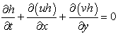 | (1) |
Momentum equations:
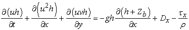 | (2) |
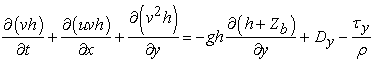 | (3) |
where h = depth of flow; u, v = depth-averaged velocity components in x and y directions, respectively; g = acceleration due to gravity; zb = bed elevation; Dx, Dy = diffusion term in x and y direction, respectively; τx, τy = x- and y- components of bottom-friction, respectively; and ρ = density of water.
The bed load in the depth-averaged velocity direction qb can be calculated as:
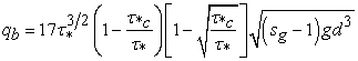 | (4) |
in which  = dimensionless critical shear stress;
  = dimensionless total bed shear stress acts on the channel bed
  , with Ie = energy slope, sg = specific gravity; d = sediment diameter.
Finally, the bed deformation can be written as:
 | (5) |
where qx, qy = bed load transport rates per unit width in x- and y- directions, respectively; and  = porosity of bed materials; qsu = rate of entrainment of suspended sediment; wf = settling velocity of sediment; and cb = reference concentration at z = 0.05h.
The numbers of cells in the longitudinal and lateral directions are 120 and 44, respectively. In this study, the computation time step is used to 0.002s and the model run is made in 10min, when the temporal variations are considerably reduced as suggests by the present experiments. The details of model equations and the computation steps are discussed by Islam and Tsujimoto, 2012 [20].
3. Results and Discussion
The main purpose of this study is to understand the mechanism of levee breach and recognize the disasters risk in the floodplain, and in particular the effect of river bed height relative to floodplain (low and high) with same bed material and that of the materials of levee and bed (coarse and fine sand) with same river bed height on the levee breach are discussed in this section by using the small-scale laboratory experiments and the numerical simulation under the same conditions.
3.1. Understanding of Levee Breach Process3.1.1. Effect of River Bed Height to Floodplain
For the case of lower bed of river (Run 1), after the beginning of overflow the initial flow passes over the levee crest along with erosion near the floodplain, and afterwards, the inundation water spreads over the floodplain with vertical erosion from the breach section. Then, the horizontal widening process starts by the collapse of the levee. Whereas in the higher river bed (Run 3), though the inflow discharge is almost same as the Run 1 but the overflow depth is more and an initial stage of the erosion is in the same manner as Run 1. Hence, the breach process is quick due to the higher bed level, and flow passes rapidly by the breach to the floodplain with higher overflow head (1.0cm and 3.0cm for Run 1 and Run 3, respectively), which provides quick vertical erosion of the levee section as well as the widening of the levee starts in the shorter duration. The different time steps after overflow starts for Runs 1 and 3 are shown in snapshots Figure 3 (a-b), to investigate the breaching process utilizing with the effect of river bed height. The vertical erosion starting time, duration of vertical erosion, and transition of the breach widening from vertical to horizontal directions are varied for different river bed height. In Run 3, the erosion process is rapid, and duration of the vertical erosion before widening (7 to 17s) and the transition of breach expansion (18s) from vertical to horizontal direction are earlier than that in Run 1.

 Run 1; (b) Run 3) PowerPoint Slide
PowerPoint Slide Larger image(png format)
The relationship between the vertical erosion and the horizontal breach widening with time (t=10min) in the cases with the low (Run 1) and the high (Run 3) river bed levels relative to floodplain is depicts in Figure 4 (a-b). For both cases, an initial opening is provided as 10cm long and 5cm deep from the top of the levee. Levee breach is measured in the vertical and the horizontal direction with respective time steps. The horizontal widening and vertical erosion length are taken from the maximum values in the specific cross-section of the levee. From the simulation results in Run 1 showed that the vertical erosion is dominated at an early stage of breaching, then the erosion process is ended; but the horizontal widening process is progressed with time at the same rate (e.g. Figure 4.a). In Run 3, both in experiments and numerical simulations have exposed that the vertical erosion and the horizontal widening process appears rapidly at shorter duration and then the vertical erosion is weakened but widening is still in progress with an increased rate (e.g. Figure 4.b). Horizontal widening is almost double in Run 3 (141cm) than Run 1 (70cm) because of higher bed elevation with high overflow head. It can be concluded that the higher river bed has the high risk for flood disasters in the floodplain.
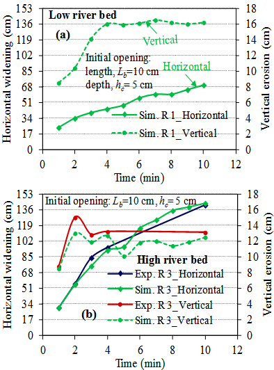
 Run 1; (b) Run 3) PowerPoint Slide
PowerPoint Slide Larger image(png format)
3.1.2. Effect of Levee and Bed Materials
In the case of coarse bed material (Run 2), almost the same feature of the erosion process appears initially as Run 1; subsequently, the erosion process comes forward to the heel (inside edge of levee base at river side) of the levee, and the material is washed out, then the horizontal widening process starts. On the other hand, in the case of fine bed material (Run 5), the erosion process starts between the levee toe and the centre of the levee, and at the same time the material in the levee section is eroded vertically. Suddenly, the erosion process dominates in the levee with huge vertical erosion. Finally, the horizontal breach with widening process starts by loss of the levee section. During the breach widening, the erosion process comes forward to the heel of the levee as well as in the river bed. Levee breaching with time after the overflow starts for Runs 2 and 5 are shown in snapshots of Figure 5 (a-b). In both runs, the comparisons clarify the effects of the materials of levee and bed on the levee breaching. In Run 2, though the duration of vertical erosion before widening (8 to 21s) and the transition of breach expansion (22s) from the vertical to the horizontal direction are earlier but the feature of the erosion is more complex with more longitudinal expansion and higher deposition on the floodplains are seen in Run 5.

 Run 2; (b) Run 5) PowerPoint Slide
PowerPoint Slide Larger image(png format)
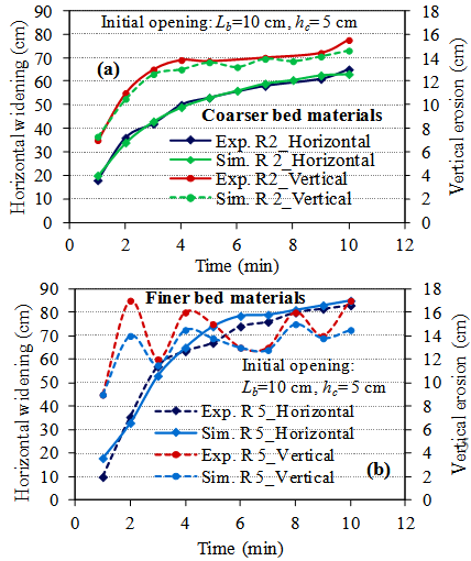
 Run 2; (b) Run 5) PowerPoint Slide
PowerPoint Slide Larger image(png format)
The relationships between the vertical erosion and the horizontal breach widening with time are shown in Figure 6, which represents the results for the cases of the same bed height of the river to floodplain using coarse and fine bed materials with almost same inflow discharges (8.71 and 8.85lit/s for the experiments and simulation Runs 2 and 5, respectively). In Run 2, the breaching process is progressed both in the horizontal and the vertical directions, then the progressive rates become slowly with time. Whereas in Run 5, more vertical erosion is progressed in the beginning of the breach, then the vertical erosion rate is decreased with showing the fluctuation with time; but initially the horizontal widening is increased rapidly, then it is declined with time. Both in experiments and simulation analysis, the effect of bed materials exposed that the finer bed material has the higher risk not only the vertical erosion but also the horizontal widening (65cm for Run 2 and 83cm for Run 5) of the levee as well as it brings more sedimentation (0.037m3 for Run 2, while 0.059m3 for Run 5) on the floodplain.
3.2. Phenomena in River and FloodplainThe final bed topographic pattern in the river channel, levee and floodplain at 10 min are depicted in Figure 7 (Runs 1 and 3) and Figure 8 (Runs 2 and 5), after the overflow from the initial notch of the levee for both in the experiments and in the simulation. Bed topographic patterns in the floodplain, river and levee section are denoted by (a) and (b) in the figures, respectively. For the case of the lower river bed (Run 1), the vertical erosion is observed on the levee section and a thalweg is formed along the flow direction from the river to the floodplain. Deposition pattern in the floodplain is smooth because of coarser bed material, and it indicates that the flow passes to the right-side direction of the floodplain in the figure (Exp.R1, Sim.R1). In the case of the higher river bed (Run 3), little erosion is observed in the downstream side of the levee and the river bed, and the breach levee section during early stage is embedded by the newly eroded material from the levee and the river bed. The sedimentation thickness in the floodplain is more in Run 3 than Run 1. Higher bed level is more dangerous because the river bed deformation in the upstream of the breach appears and floodplain scouring and deposition on the floodplain by the breach are more serious (Exp.R3, Sim.R3).

 and simulation (Sim.R1, Sim.R3) results of bed topographic changes (t=10min): (a) Floodplain; (b) River channel and levee section) PowerPoint Slide
PowerPoint Slide Larger image(png format)
The case of coarse bed material (Run 2), smaller erosion is seen on the levee section and less serious deposition pattern on the floodplain is shown in Figure 8. Thus, the flow behaves all over the floodplain and has a tendency to shifting toward the right-side in the floodplain (Exp.R2, Sim.R2). In the case of fine bed material (Run 5), rather the river bed material is more eroded and deposited on the floodplain by the breach than the levee material, and then a thalweg is formed inside the river near the levee and along the flow direction. The thickness of deposition is higher on the floodplain than Run 2 (Exp.R5 and Sim.R5).
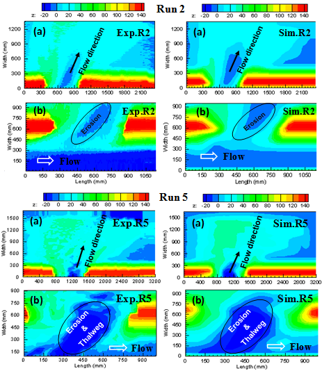
 and simulation (Sim.R2, Sim.R5) results of bed topographic changes (t=10min): (a) Floodplain; (b) River channel and levee section) PowerPoint Slide
PowerPoint Slide Larger image(png format)
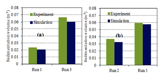
: (a) For River bed height; and (b) For Levee and bed materials) PowerPoint Slide
PowerPoint Slide Larger image(png format)
Comparisons of floodplain sedimentation among different river bed height and bed materials are depicted in the Figure 9 (a-b), where the results of both experiment and simulation are shown. The floodplain sedimentation is promoted for the high river bed level (Run 3). While the deposition volume is more for the fine bed material (Run 5) than that of the coarse material (Run 2) when the results are compared in the same river bed height.
3.3. River Bed Changes Accompanying Levee BreachThe river bed variations are compared between the cases at different relative heights of river bed to floodplain and bed materials, and they are depicted in Figure 10 (a-b) for both experiments and simulation. The higher rates of changes in the breaching processes are observed in Run 3 than Run 1. For the same river bed height with only changes in the materials of levee and bed, the results showed that the fine bed material (Run 5) are more dangerous because more bed deformation appears there, which brings more deposited on the floodplain by the breach.

 For River bed height; and (b) For Levee and bed materials) PowerPoint Slide
PowerPoint Slide Larger image(png format)
4. Conclusions
Although the levee breach phenomenon is three-dimensional but in this paper we employed two dimensional numerical simulation schemes to analyze the levee breach phenomena not only at levee but also from the river to floodplain. The conclusions of the present study are summarized as follows:
1. The results of small-laboratory experiments and the numerical calculations based on 2D scheme with the same condition show essentially good agreements, though there are some discrepancies among them. Employing these two methodologies complementarily is expected to play a powerful means to understand the mechanism of levee breach and the risk of disasters.
2. Higher river bed is exposed to a risk of levee breach with high overflow head, and thus the breach widening is rapid and inundation with more sediment is expected on the floodplain. In addition, degradation on the upstream of the river bed appears to bring further risk of breach.
3. In the case of coarse bed material, initially the erosion process starts mainly on the levee crest and the breach progresses with the washout of the levee material with time; whereas in the case of fine bed material, the features of breach phenomena are different with huge vertical erosion in the levee section and clear river bed deformation which brings high risk of disasters on the floodplain.
Acknowledgements
The authors are grateful to MEXT, for the financial support required in the study. They wish to thank Dr. Takashi Tashiro, Mr. Yoshiike and other students of the Hydraulic Engineering Laboratory of Nagoya University for their assistance during experiment setup and data measurements.
References
| [1] | Ahmed, S. M. U., Hogue, M. M. and Hossain, S. “Floods in Bangladesh: a hydrological analysis,” Final Report R01/92, Institute of Flood Control and Drainage Research (IFCDR), Bangladesh University of Engineering and Technology (BUET), Dhaka, pp. 1-5, 1992. | ||
 In article In article | |||
| [2] | Sarker, M.H., Huque, I., Alam, M. and Koudstaal, R. “Rivers, chars, char dwellers of Bangladesh,” Int. J. of River Basin Management, 1, pp. 61-80, 2003. | ||
| In article | CrossRef | ||
| [3] | Tingsanchali, T. and Karim, M. F. “Flood hazard and risk analysis in the southwest region of Bangladesh,” J. of Hydrological Process, 19, pp 2055-2069, 2005. | ||
| In article | CrossRef | ||
| [4] | S. A. Schumm and B. R. Winkley. “The character of large alluvial rivers, in: the variability of large alluvial rivers (Ed. by S.A. Schumm and B.R. Winkley),” American Society of Civil Engineers, New York pp 1-13, 1994. | ||
| In article | |||
| [5] | Fujita, Y. and Tamura, T. “Enlargement of breaches in flood levee on alluvial plains,” J. of Natural Disaster Science, 9 (1) pp. 37-60, 1987. | ||
| In article | |||
| [6] | Aureli, F. and Mignosa, P. “Comparison between experimental and numerical results of 2D flows due to levee-breaking,” XXIX IAHR Congress Proceedings. Theme C, September 16-21, 2001, Beijing, China. | ||
| In article | |||
| [7] | Tsujimoto, T. and Mizoguchi, A. and Maeda, A. “Levee breach process of a river by overflow erosion, River Flow,” Int. Conf. on Fluvial Hydraulics, Lisbon pp. 1547-1555, 2006. | ||
| In article | PubMed | ||
| [8] | Zhu, Y., Visser, P.J. and Vrijling, J.K. “Laboratory observations of embankment breaching,” 7th Int. Conf. on Hydroscience and Engineering (ICHE-2006), Philadelphia, USA, pp. 1-10, 2006. | ||
| In article | |||
| [9] | Shimada, T., Watanabe, Y., Yokoyama, H. and Tsuji, T. “An Experiment on Overflow-Induced Cross-Levee Breach at the Chiyoda Experimental Channel,” River, Coastal and Estuarine Morphodynamics, 1, pp. 475-481, 2009 (in Japanese). | ||
| In article | |||
| [10] | Shimada, T., Hirai, Y. and Tsuji, T. “Levee Breach Experiment by Overflow at the Chiyoda Experimental Channel,” 9th Intl. Conference on Hydro-science and Engineering, IAHR August 2- 5, 2010. | ||
| In article | |||
| [11] | Islam, M.S. and Tsujimoto, T. “Comparisons of Levee Breach and Successive Disasters in Floodplain between Bangladesh and Japan,” Procedia Engineering, Elsevier publication, 28, pp. 860-865, 2012. | ||
| In article | |||
| [12] | Islam, M.S. and Tsujimoto, T. “Experimental and Numerical Approaches to Overtopping Levee Breach Effects in a River and Floodplain,” American Journal of Civil Engineering, 3 (2), pp. 31-42, 2015. | ||
| In article | |||
| [13] | Islam, M. S. Tashiro, T. and Tsujimoto, T. “Laboratory experiments on levee breach and inundation in low-land with particular reference to relative height of river bed to floodplain,” Intl. Review of Civil Engineering, Italy, 3 (3) pp. 251-258, 2012. | ||
| In article | |||
| [14] | Itaya, S. and Tejima, T. “Weir flow formula of a rectangle with a basis of reebok`s formula,” Proceedings of the Society of Mechanical Engineers, 17 (56) pp. 5-7, 1951(in Japanese). | ||
| In article | CrossRef | ||
| [15] | Kurokawa, H. and Fuchizawa, T. “Formula of triangular weir flow,” Proceedings of the society of Mechanical Engineers, 7 (27) p. 5, 1942 (in Japanese). | ||
| In article | |||
| [16] | Hokkaido Foundation for River Disaster Prevention Research Center: RIC-Nays, http://i-ric.org/nays/ja/sitemap.html. | ||
| In article | |||
| [17] | Ashida, K. and Michiue, M. “Study on hydraulic resistance and sediment transport rate in alluvial stream,” Transactions, JSCE, 206 pp. 55-69, 1972 (in Japanese). | ||
| In article | |||
| [18] | Hasegawa, K. and Yamaoka, S. “The effect of plane and bed forms of channels upon the meander development,” J. of Hydraulic, Coastal and Environmental Engineering, JSCE, 29 pp.143-152, 1980 (in Japanese). | ||
| In article | CrossRef | ||
| [19] | Engelund, F. “Flow and bed topography in channel bend,” J. of Hydraulic Division, ASCE, 100 (11) pp. 1631-1648, 1974. | ||
| In article | |||
| [20] | Islam M. S. and Tsujimoto, T. “Numerical approach to levee breach as a key of flood disasters in low land,” Int. J. of Civil Engineering, India, 4 (1) pp. 23-39, 2012. | ||
| In article | |||

 CiteULike
 Delicious

