As a vital socio-economic artery in Khulna’s urban fabric, Boro Bazar and adjacent connected surrounding marketplaces highlighting the intricate relationships between walkability, informality, and spatial justice amid the city's rapid urbanisation. This study applies a qualitative case study approach focused on four important dimensions: inclusiveness, comfort-safety, pedestrian infrastructure, and connectivity to examine the walkability of Boro Bazar and the adjacent interconnected marketplace, which is Khulna's oldest and busiest neighborhood. The market's dense spatial connectivity and constant activity are advantageous, but vendor encroachments, inadequate pedestrian infrastructure, poor lighting, and a lack of amenities for women, children, the elderly, and people with disabilities affect walkability, according to field observations, morphological mapping, and informal interviews. In order to turn the marketplaces into a more lively and equitable public space, the findings highlight the necessity of integrated design and planning techniques, such as designated vendor zones, improvements to the pedestrian infrastructure, and reconnection with the riverfront.
Walkability is more than movement, it is a social infrastructure in the context of Boro Bazar area, Khulna. The term ‘Walkability’ has become a defining measure of urban liveability in South Asia’s rapidly transforming cities, where the built environment increasingly dictates access, mobility, and social equity. In Bangladesh, where informal markets and spontaneous urban activities dominate public life, walkability is not merely a matter of mobility but also of social equity and spatial justice 1, 2. Khulna’s Boro Bazar and its surrounding interconnected marketplaces are among the oldest and most active in the city, exemplify the socio-spatial challenges facing pedestrian movement in densely congested commercial areas. As a high-density market located near the Rupsha River, Boro Bazar and surrounding marketplace host formal retail spaces, informal vendors, and multiple transport intersections, creating a complex urban fabric often hostile to pedestrian accessibility and comfort 3, 4. Despite its economic and cultural centrality, the area suffers from encroached footpaths, poor surface quality, unregulated vending, and traffic congestion, all of which diminish walkability and inclusivity, especially for women, the elderly, and individuals with disabilities 5. These limitations are exacerbated by weak urban policy implementation and a lack of pedestrian-oriented planning in city master plans 6. Enhancing walkability in Boro Bazar and interconnected surrounding marketplace, therefore, requires not only infrastructural upgrades but also a recognition of informal practices and inclusive design strategies. By integrating the principles of human-centered design and local placemaking, Boro Bazar could evolve into a more walkable, accessible, and socially vibrant space that aligns with sustainable urban development goals 7.
Walkability is a crucial aspect of urban vitality, directly influencing commercial activity, social interaction, and the everyday lives of city dwellers. In Khulna, the Boro Bazar and its surrounding connected marketplace areas are an emblematic riverside marketplace that illustrates both the potential and the limitations of pedestrian-friendly urban design in the context. Established alongside the Rupsha River, Boro Bazar has evolved into a dense, multifunctional precinct integrating formal retail, informal vendors, and transport access 3. However, like many emergent urban spaces in rapidly growing cities, its widespread informal use challenges conventional infrastructure planning and pedestrian safety 4, 8. The concept of walkability encompasses physical, social, and perceptual dimensions of the pedestrian realm 9, 10. Yet the lived experience of walkability often diverges from design intentions, as narrow pathways, vendor encroachments, and congested parking inhibit pedestrian movement and compromise accessibility 3, 11. These conditions align with phenomena documented in other South Asian markets, where informal economies coexist with insufficient pedestrian infrastructure 12.
City planning documents, including the 2001–2010 Khulna City Master Plan, emphasized economic zones and site-specific infrastructure improvements, but often overlooked pedestrian-scale public realm needs 6. Recent studies have stressed the urgent need for targeted walkability interventions: continuous footpaths, traffic management, formalized vendor zones, and active community participation in design decision-making 4, 13. Theoretical frameworks further enrich this practical discourse. Jacobs’s 14 advocacy for short blocks and mixed-use streets, Gehl’s 15 emphasis on human-scale design, and Dovey and Pafka’s 16 Urban DMA model foreground the interplay of density, mix, and access. In Boro Bazar, this means creating pedestrian corridors that sustain social exchange, economic activity, and safety simultaneously. Additionally, Harvey’s 17 and Lefebvre’s 1 emphasis on the right to the city demands that walkable design in Boro Bazar be inclusive, extending access to all socioeconomic groups and fostering equitable use of public space. Studies illustrate that walkable markets enhance community resilience, support informal economies, and foster public interaction 18, 19. Improving walkability in Boro Bazar could not only facilitate commerce but also improve emotional wellbeing, social cohesion, and cultural continuity 15, 20. Enhancing walkability in Boro Bazar and surrounding connected marketplace, demands integrated interventions of improving infrastructure, regulating vendors, embracing cultural heritage, and fostering community engagement and need to grounded in global theories and South Asian urban realities.
Walkability, defined as the extent to which the built environment supports and encourages walking by providing safe, comfortable, and accessible pathways, is a critical dimension of sustainable urban design. The walkability of public spaces, such as marketplaces, is influenced by the physical mobility of urban residents, as well as their social interactions, health outcomes, and sense of belonging 10, 21. Over the past two decades, walkability has evolved from a transportation-related concept to a broader socio-spatial framework encompassing urban form, land use, and quality of life 9, 16. Walkability is especially relevant in marketplace areas, where pedestrian activity is vital to local commerce and social vibrancy. Foundational work by Jacobs 14 emphasized the need for short blocks, mixed land use, and active street fronts to promote "eyes on the street," enhancing both safety and sociability. Similarly, Gehl 15 argued that cities should be designed at the human scale, where walking is encouraged by the proximity of destinations, comfortable walking environments, and opportunities for social interaction. These early insights laid the groundwork for more analytical approaches to walkability. In order to evaluate walkability, recent research has presented quantitative models. Alfonzo 9 created a hierarchy of walking needs that included safety, comfort, and feasibility, while Cervero and Kockelman 1 presented the "3Ds" model (Density, Diversity, and Design) as important predictors of travel behaviour. Building on this, the Urban DMA framework (Density, Mix, and Access) was presented Dovey and Pafka 16 as a more integrated spatial model of walkability that takes into account social patterns and urban shape.
In South Asian contexts, however, walkability theory must be interpreted in light of local conditions such as high pedestrian dependency, informal economic activities, encroachments, and inadequate infrastructure 22. In cities like Khulna, Bangladesh, where informal vendors dominate streetscapes and pedestrian infrastructure is limited, walkability is shaped not only by design but also by socio-economic pressures and governance 5, 8. Studies highlight that in such context’s public spaces, including marketplaces, are functioning as vital pedestrian corridors that accommodate walking, socializing, informal trade, and transit simultaneously 23. Yet, these spaces are often congested, poorly maintained, and unsafe, particularly for vulnerable groups such as the elderly, women, and people with disabilities. The concept of walkability thus intersects with broader urban justice concerns. Harvey 17 and Lefebvre 1 have emphasized the importance of equitable access to urban space, arguing that walkability is not just about movement but about the right to the city. Inclusive walkability ensures that urban form does not marginalize, but rather connects diverse populations to essential services, social opportunities, and civic life 24, 25. In the case of Khulna's Boro Bazar and the interconnected marketplaces around it, it is necessary to integrate design enhancements with inclusive, context-specific planning in order to increase pedestrian walkability from both a physical and social standpoint.
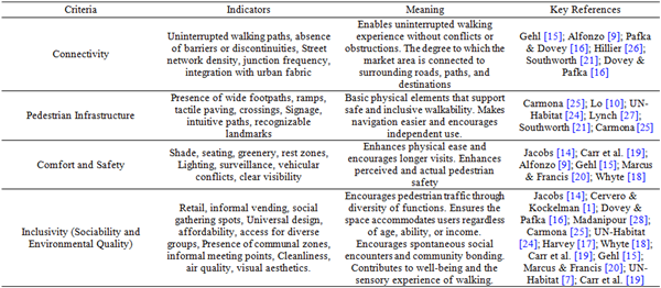
This case study employs qualitative methods to evaluate the walkability of Boro Bazar, the oldest and largest retail and wholesale marketplace in Khulna city, focusing on its spatial and experiential qualities. The assessment framework is structured around four thematic criteria: Connectivity, Pedestrian Infrastructure, Comfort and Safety, and Inclusivity, which encompasses sociability and environmental quality (Table 1). Data collection techniques include casual conversations with market users, morphological mapping of the built environment, and detailed analysis of land use patterns, pedestrian facilities, and accessibility for both pedestrians and vehicles. Observations of spatial behavior and activity patterns provide insights into how the marketplace functions as a pedestrian realm.
Thematic analysis is applied to qualitative data to identify recurring themes and interpret how the identified criteria contribute to creating a walkable environment that supports spontaneous social interaction, comfort, and safety. This multi-method approach facilitates a nuanced understanding of the socio-spatial dynamics influencing walkability, emphasizing the lived experiences of diverse users within the marketplace. By integrating physical spatial analysis with user perceptions and behaviors, the study reveals the complex interplay between urban form, infrastructure provision, and social use, underscoring the critical role of walkability in sustaining the vibrancy and inclusiveness of marketplaces in Khulna’s urban fabric.
Study area:
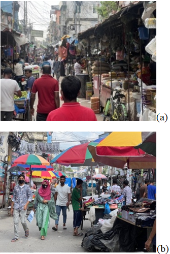
Boro Bazar is one of the oldest and most dynamic commercial marketplaces in Khulna, located in the Dak Bangla area near the banks of the Rupsha River. Based on the Boro Bazar, a variety of marketplaces have been created and positioned as an integrated part of the oldest city's marketplace overall. Functioning as a vital economic and social hub, Boro Bazar exemplifies the integration of formal retail structures with informal street vending, embedded within a dense and multifunctional urban fabric 3. The marketplace is centrally situated, with strong connectivity to major transport nodes including the Dak Bangla intersection, nearby rickshaw, riverways, BIWTA Launch Terminal, local transports, and the adjacent railway line (Figure 1). Historically rooted in Khulna’s colonial trade history, the area continues to thrive as a center of commerce, cultural exchange, and everyday life.
The spatial character of Boro Bazar is shaped by a mix of permanent shops, hawker zones, warehouses, food markets, alongside government offices, banks, mosques, and educational institutions (Figure 2). These diverse land uses foster continuous pedestrian activity from early morning until late evening, making the area a vibrant public realm. Despite its economic importance, the marketplace faces challenges related to overcrowding, poor pedestrian infrastructure, encroachments, and insufficient sanitation facilities 4, 11. Nevertheless, its sociability, spatial permeability, and cultural relevance position it as a spontaneous urban public space. The coexistence of informal and formal functions contributes to its adaptability, illustrating how everyday pedestrian life navigates the complexities of urbanization in a South Asian marketplace.
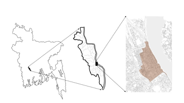
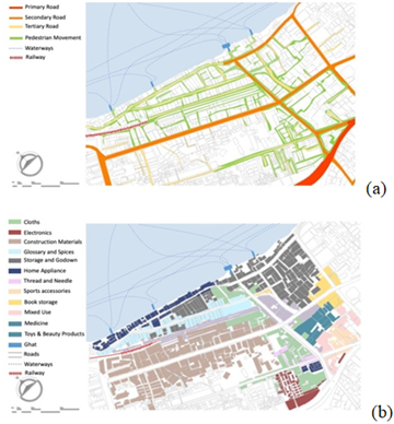
The intricate connectivity profile of the Boro Bazar Marketplace is a result of both its historical development and the current informal-commercial dynamics. Located at the urban core of Dak Bangla, the area benefits from a dense street network (both pedestrian and vehicular) and high junction frequency (several nodal points; Mohendra Das More, Station Road More, Helatola More, Kalibari More, Station Road More, Dak Bangla More, Picture Place More, Thanar More, and Vairob Stand More) that connects it to key commercial and transport corridors, including Lower Jessore Road, Clay Road, Vairob Stand Road, Station Road, Railway Hospital Road and the nearby Rupsha riverfront Ghats (Kachari Ghat, Jutapotti Ghat, Rocket Ghat, and Kalibari Ghat) (Figure 3, a). A complex market system spine is produced by the creation of multiple tertiary road connections, such as a branch system, in addition to the main roadways. The market’s overall spatial integration with the surrounding urban fabric, including the Khulna Railway, BIWTA Launch Terminal, government administrative zones, and residential areas, generates high pedestrian footfall and supports multifunctional use by diverse user groups (Figure 3, b). While tertiary roads are mostly utilized for pedestrian movement and allow access for people to pull a carrier to distribute the items in the nearby area, secondary roads serve both vehicle and pedestrian accessibility simultaneously.
However, despite this inherent potential, the walkability experience remains fragmented due to several critical barriers. Uninterrupted pedestrian movement is frequently compromised by encroachments from informal vendors, discontinuous footpaths, and abrupt transitions between vehicular and pedestrian zones (Figure 4, a). Field observations reveal that narrow alleys (some less than 1.5 meters wide) are further congested by static obstacles such as vendors, parked rickshaws, goods carts, and utility poles (Figure 4, b). The permeability of the area is significantly disrupted by the absence of designated pedestrian crossings and traffic signals, especially in the nodal areas where flow of people is very high such as Clay Road More, Dak Bangla More, and Station Road More. As well as the presence of obstructive elements such as billboards, electric poles, wiring, dustbins, and other unnecessary street furniture are placed all over the roads (Figure 4, b).
The pedestrian infrastructure in Boro Bazar, Khulna, reflects a mixed level of accessibility and usability. While some sections of the market feature moderately wide footpaths (4 to 5 feet), these are always encroached upon by informal vendors and parked vehicles, reducing walkable space (Figure 4, a). Due to the absence of dedicated pedestrian infrastructure, people are forced to use vehicular roads for daily access, despite the majority of market visitors being women (62%), children (5%), and the elderly (14%), yet the area lacks essential amenities such as seating and restroom facilities for these user groups. The area lacks consistent ramps and tactile paving, making movement difficult for persons with disabilities and the elderly. Formal pedestrian crossings are rare, contributing to unsafe road navigation. Wayfinding is also limited, as clear signage and intuitive pathways are largely absent. However, most of the nodal points has its notable landmarks, historic buildings or iconic infrastructure which bring out the characteristics of that area.
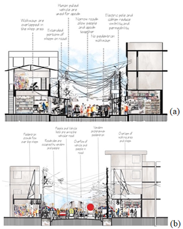
In the urban fabric of Boro Bazar, Khulna, basic amenities that support pedestrian comfort and safety, such as shading structures, seating, and restrooms are largely absent. While a small portion of shops provide temporary shade through self-installed canopies, these offer only minimal relief from heat and sun exposure (Figure 4, b). Public seating and restroom facilities are missing throughout the area, further limiting accessibility, particularly for women, the elderly, and children. Most of the market infrastructure lacks adequate lighting; a few skylight openings exist in the inner market rows, but beyond these, interior spaces remain dim and poorly illuminated (Figure 5, a).
Roadside shops rely on external light sources, while the central alleys remain dark, which reduces visibility and heightens users’ perceptions of insecurity, particularly after sunset. Although separate vehicular and pedestrian paths exist in areas such as Clay Road and Station Road, their functionality is severely compromised due to the encroachment of vendors onto both pedestrian walkways and portions of the roads (Figure 5, b). Consequently, pedestrians are often forced to walk on vehicular roads, creating congestion and conflict between pedestrians and vehicles during peak hours. Furthermore, although 94% of the shops are connected through inner pedestrian alleys, the lack of proper lighting exacerbates safety concerns, especially for women, children, and the elderly-groups that collectively make up a significant portion of market users (Figure 3, a, and b).
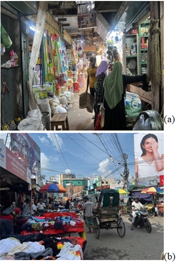
The Boro Bazar marketplace in Khulna serves as a vital socio-economic hub that supports inclusivity through its dense retail environment and vibrant informal vending culture (Figure 4, a). Areas such as Clay Road, Station Road, Vairab Stand Road and Boro Bazar Road with the connecting lane-side alleys are occupied by both permanent shops and mobile vendors, creating accessible, low-cost options for a wide range of users, particularly low-income groups (Figure 2, a). These locations function as informal social gathering points, where shoppers, vendors, rickshaw-pullers, and passersby engage in everyday interactions, reinforcing the area’s role as a communal zone (Figure 4, a and b). However, there are no formal seating zones or shaded communal areas to support prolonged stays or rest (Figure 3, b). Visual aesthetics are often diminished by haphazard vendor arrangements, poor waste management, and inconsistent building facades (Figure 2, a). Air quality is notably poor due to the presence of unregulated motorized traffic and waste in nearby corners such as the Clay Road, Helatola More and Kalibari More. Only a limited number of food stalls are distributed across the Boro Bazar area, yet these stalls function as informal pause spaces, fostering social interaction among shoppers. Despite the lack of greenery and shaded areas, the marketplace benefits from its proximity to the Rupsha River, which emphasises the historical development of Khulna city. However, there is a notable absence of visual or physical connections to the riverfront; no designated infrastructure or public access points exist that would allow visitors to experience or enjoy the scenic river (Figure 1).
A complicated walkability profile is revealed by Khulna's Boro Bazar, which is determined by the historical topography of the area as well as the evolving informal-commercial dynamics of the urban center. Its dense street networks and frequent intersections, like Station Road More and Dak Bangla More, reflect its high connectivity, which is indicative of what Marshall 29 refers to as "urban grain," a condition that promotes permeability and multidirectional access and is crucial for connecting walkability with the city's urban fabric. In line with Dovey and Pafka's 16 observations on the spatial tension between informality and accessibility in emergent urban markets, which also influenced the flow of walkability and permeability in a wide range of ways, this spatial integration links Boro Bazar and surrounding marketplaces to vital commercial and riverine infrastructures, but permeability is severely hampered by informal vendor encroachments and the lack of pedestrian prioritisation.
The coexistence of narrow paths and informal encroachments in pedestrian infrastructure intensifies discomfort, particularly for women, children, and the elderly, reflecting Loukaitou-Sideris's 30 findings on gendered spatial exclusion in urban marketplaces. The lack of tactile paving, ramps, and formal signage further impedes mobility for individuals with impairments, echoing global issues highlighted by UN-Habitat 7 about universal design in densely populated urban environments. When it comes to comfort and safety, inadequate seating, lighting, and rest areas make users more vulnerable, especially after dark. This aligns with Gehl’s 2 assertion regarding the significance of human-scale lighting and unobstructed visibility in fostering secure urban settings. Informal canopy curtains offer merely limited thermal comfort, not satisfying the standards for thermally inclusive design 31. Boro Bazar is affordable and lively, which helps make it more inclusive and improve the environment. It provides important services to people with low and intermediate incomes. Informal vending around Clay Road and Vairab Stand exemplifies "tactical urbanism" 32, enhancing accessibility where formal infrastructure break down. Yet the lack of greenery, seating, visual order, and poor air quality—especially from waste burning near Old Municipality Lane—undermines long-term social cohesion and well-being 19. Moreover, despite its adjacency to the Rupsha River, the absence of visual or physical access to the waterfront reflects missed opportunities in landscape integration and experiential urban design 27, 33.
In summary, the walkability of Boro Bazar is limited due to the absence of certain infrastructures and the battle for space that exists between formal and informal entities. In order to improve walkability, coordinated design interventions are required. These interventions include the reconfiguration of pedestrian zones, the augmentation of lighting, the incorporation of inclusive amenities, and the integration of ecological elements. These are all methods that are in line with contemporary placemaking frameworks 25, 34. The implementation of such strategies has the potential to convert Boro Bazar from a functionally crowded node into a public marketplace that is vibrant and welcoming to everybody.
This investigation examines the walkability of Boro Bazar and surrounding interconnected marketplaces, a historically important and multifunctional commercial center in Khulna, through an analysis of its spatial connectivity, pedestrian infrastructure, environmental comfort, and inclusivity. The pedestrian experience, while situated in a highly accessible and dynamic socio-economic context, is compromised by factors such as unregulated street vending, narrow or discontinuous footpaths, and a lack of essential urban amenities including lighting, seating, and clear wayfinding. Concerns regarding safety, especially for women, children, older adults, and individuals with disabilities, are exacerbated by inadequate infrastructure and spatial overcrowding. Moreover, the deficiencies in environmental quality, inadequate riverfront integration, and disjointed governance hinder the area from realising its complete potential as a socially inclusive public space. A comprehensive, multi-level approach is essential to promote fairness, resilience, and walkability. To enhance the walkability of the Boro Bazar area, attention should be directed towards
• Establish pedestrian-priority zones: Clearly define walking areas with controlled vending to minimise encroachment and enhance mobility.
• Enhance pedestrian infrastructure: Guarantee uninterrupted, clear footpaths; implement sufficient lighting, signage, and shaded seating options.
• Apply principles of inclusive design: Integrate ramps, tactile paving, and resting areas to accommodate the needs of elderly individuals, users with disabilities, and children.
• Enhance the riverfront: Incorporate it as a vibrant public area with boardwalks, seating, and improved pedestrian connections.
• Enhance governance and foster community involvement: Facilitate collaboration among municipal agencies and local stakeholders to guarantee effective and inclusive management of public spaces.
| [1] | R. Cervero and K. Kockelman, “Travel demand and the 3Ds: Density, diversity, and design,” Transp. Res. D: Transp. Environ., vol. 2, no. 3, pp. 199–219, 1997. | ||
| In article | View Article | ||
| [2] | J. Gehl, Cities for People. Washington, DC: Island Press, 2011. | ||
| In article | |||
| [3] | I. Reazul and R. Alam, “The dynamics of informal economy in the transformation of public space: A case study of Khulna Boro Bazar,” BUET J. Archit., vol. 10, no. 2, pp. 33–42, 2012. | ||
| In article | |||
| [4] | F. Hameed, “Urban informality and walkability in Khulna city: A case of Boro Bazar,” Urban Res. Develop. Rev., vol. 7, no. 2, pp. 44–56, 2021. | ||
| In article | |||
| [5] | R. Roy, T. R. Chowdhury, and M. M. Islam, “Informality and urban planning in secondary cities of Bangladesh: A case of Khulna,” Planning Perspect., vol. 37, no. 1, pp. 35–58, 2022. | ||
| In article | |||
| [6] | M. H. Chaudhury, Master Plan for Khulna City, 2001–2010. Dhaka: Urban Development Directorate, Government of Bangladesh, 2010. | ||
| In article | |||
| [7] | UN-Habitat, World Cities Report: The Value of Sustainable Urbanization. Nairobi: United Nations Human Settlements Programme, 2020. | ||
| In article | |||
| [8] | S. Akter and K. Mahmud, “Pedestrian movement and walkability in Khulna city: A case study of Boro Bazar,” J. Bangladesh Inst. Planners, vol. 10, pp. 79–92, 2017. | ||
| In article | |||
| [9] | M. A. Alfonzo, “To walk or not to walk? The hierarchy of walking needs,” Environ. Behav., vol. 37, no. 6, pp. 808–836, 2005. | ||
| In article | View Article | ||
| [10] | R. H. Lo, “Walkability: What is it?,” J. Urbanism: Int. Res. Placemaking Urban Sustain., vol. 2, no. 2, pp. 145–166, 2009. | ||
| In article | View Article | ||
| [11] | F. H. Mallick and M. Naqi, “Informal trading and urban space in Bangladesh: Case study of Khulna Boro Bazar,” Urban Stud. Rev., vol. 3, no. 1, pp. 51–66, 2008. | ||
| In article | |||
| [12] | L. Kennedy, M. Clark, and C. Clouse, The Politics of Urban Informality in South Asia. London: Routledge, 2019. | ||
| In article | |||
| [13] | T. Anjum and R. Roy, “Women’s mobility and the urban form: A case study of Khulna, Bangladesh,” J. Int. Women’s Studies, vol. 20, no. 7, pp. 125–138, 2019. | ||
| In article | |||
| [14] | J. Jacobs, The Death and Life of Great American Cities. New York: Random House, 1961. | ||
| In article | |||
| [15] | J. Gehl, Life Between Buildings: Using Public Space. Washington, DC: Island Press, 1987. | ||
| In article | |||
| [16] | K. Dovey and E. Pafka, “What is walkability? The urban DMA,” Urban Stud., vol. 57, no. 1, pp. 93–108, 2020. | ||
| In article | View Article | ||
| [17] | D. Harvey, A Brief History of Neoliberalism. Oxford: Oxford Univ. Press, 2005. | ||
| In article | View Article | ||
| [18] | W. H. Whyte, The Social Life of Small Urban Spaces. Washington, DC: Project for Public Spaces, 1980. | ||
| In article | |||
| [19] | S. Carr, M. Francis, L. G. Rivlin, and A. M. Stone, Public Space. Cambridge: Cambridge Univ. Press, 1992. | ||
| In article | |||
| [20] | C. C. Marcus and C. Francis, People Places: Design Guidelines for Urban Open Space. New York: John Wiley & Sons, 1998. | ||
| In article | |||
| [21] | M. Southworth, “Designing the walkable city,” J. Urban Planning Develop., vol. 131, no. 4, pp. 246–257, 2005. | ||
| In article | View Article | ||
| [22] | R. Sharma and P. Newman, “Urban form and transport in Indian cities: A review,” Urban Planning, vol. 3, no. 2, pp. 34–45, 2018. | ||
| In article | |||
| [23] | S. Das, J. Sen, and S. A. Khan, “The impact of informal trade on walkability in South Asian cities,” J. Urban Affairs, vol. 44, no. 2, pp. 309–325, 2022. | ||
| In article | |||
| [24] | UN-Habitat, Global Public Space Toolkit: From Global Principles to Local Policies and Practice. Nairobi: United Nations Human Settlements Programme, 2015. | ||
| In article | |||
| [25] | M. Carmona, “Place value: Place quality and its impact on health, social, economic and environmental outcomes,” J. Urban Des., vol. 24, no. 1, pp. 1–48, 2019. | ||
| In article | View Article | ||
| [26] | B. Hillier, Space is the Machine: A Configurational Theory of Architecture. Cambridge: Cambridge Univ. Press, 1996. | ||
| In article | |||
| [27] | K. Lynch, The Image of the City. Cambridge, MA: MIT Press, 1960. | ||
| In article | |||
| [28] | A. Madanipour, “Why are the design and development of public spaces significant for cities?,” Environ. Planning B: Planning Des., vol. 26, no. 6, pp. 879–891, 1999. | ||
| In article | View Article | ||
| [29] | S. Marshall, Streets and Patterns. London: Spon Press, 2005. | ||
| In article | View Article | ||
| [30] | A. Loukaitou-Sideris, “Is it safe to walk? Neighborhood safety and security considerations and their effects on walking,” J. Planning Lit., vol. 20, no. 3, pp. 219–232, 2006. | ||
| In article | View Article | ||
| [31] | M. Nikolopoulou and K. Steemers, “Thermal comfort and psychological adaptation as a guide for designing urban spaces,” Energy Buildings, vol. 35, no. 1, pp. 95–101, 2003. | ||
| In article | View Article | ||
| [32] | M. Lydon and A. Garcia, Tactical Urbanism: Short-term Action for Long-term Change. Washington, DC: Island Press, 2015. | ||
| In article | View Article | ||
| [33] | A. Madanipour, Public and Private Spaces of the City. London: Routledge, 2003. | ||
| In article | View Article | ||
| [34] | Project for Public Spaces, “Placemaking: What if we built our cities around places?,” 2023. [Online]. | ||
| In article | |||
Published with license by Science and Education Publishing, Copyright © 2025 Laila Siddiqua and Md. Esfaqur Rahman
![]() This work is licensed under a Creative Commons Attribution 4.0 International License. To view a copy of this license, visit
http://creativecommons.org/licenses/by/4.0/
This work is licensed under a Creative Commons Attribution 4.0 International License. To view a copy of this license, visit
http://creativecommons.org/licenses/by/4.0/
| [1] | R. Cervero and K. Kockelman, “Travel demand and the 3Ds: Density, diversity, and design,” Transp. Res. D: Transp. Environ., vol. 2, no. 3, pp. 199–219, 1997. | ||
| In article | View Article | ||
| [2] | J. Gehl, Cities for People. Washington, DC: Island Press, 2011. | ||
| In article | |||
| [3] | I. Reazul and R. Alam, “The dynamics of informal economy in the transformation of public space: A case study of Khulna Boro Bazar,” BUET J. Archit., vol. 10, no. 2, pp. 33–42, 2012. | ||
| In article | |||
| [4] | F. Hameed, “Urban informality and walkability in Khulna city: A case of Boro Bazar,” Urban Res. Develop. Rev., vol. 7, no. 2, pp. 44–56, 2021. | ||
| In article | |||
| [5] | R. Roy, T. R. Chowdhury, and M. M. Islam, “Informality and urban planning in secondary cities of Bangladesh: A case of Khulna,” Planning Perspect., vol. 37, no. 1, pp. 35–58, 2022. | ||
| In article | |||
| [6] | M. H. Chaudhury, Master Plan for Khulna City, 2001–2010. Dhaka: Urban Development Directorate, Government of Bangladesh, 2010. | ||
| In article | |||
| [7] | UN-Habitat, World Cities Report: The Value of Sustainable Urbanization. Nairobi: United Nations Human Settlements Programme, 2020. | ||
| In article | |||
| [8] | S. Akter and K. Mahmud, “Pedestrian movement and walkability in Khulna city: A case study of Boro Bazar,” J. Bangladesh Inst. Planners, vol. 10, pp. 79–92, 2017. | ||
| In article | |||
| [9] | M. A. Alfonzo, “To walk or not to walk? The hierarchy of walking needs,” Environ. Behav., vol. 37, no. 6, pp. 808–836, 2005. | ||
| In article | View Article | ||
| [10] | R. H. Lo, “Walkability: What is it?,” J. Urbanism: Int. Res. Placemaking Urban Sustain., vol. 2, no. 2, pp. 145–166, 2009. | ||
| In article | View Article | ||
| [11] | F. H. Mallick and M. Naqi, “Informal trading and urban space in Bangladesh: Case study of Khulna Boro Bazar,” Urban Stud. Rev., vol. 3, no. 1, pp. 51–66, 2008. | ||
| In article | |||
| [12] | L. Kennedy, M. Clark, and C. Clouse, The Politics of Urban Informality in South Asia. London: Routledge, 2019. | ||
| In article | |||
| [13] | T. Anjum and R. Roy, “Women’s mobility and the urban form: A case study of Khulna, Bangladesh,” J. Int. Women’s Studies, vol. 20, no. 7, pp. 125–138, 2019. | ||
| In article | |||
| [14] | J. Jacobs, The Death and Life of Great American Cities. New York: Random House, 1961. | ||
| In article | |||
| [15] | J. Gehl, Life Between Buildings: Using Public Space. Washington, DC: Island Press, 1987. | ||
| In article | |||
| [16] | K. Dovey and E. Pafka, “What is walkability? The urban DMA,” Urban Stud., vol. 57, no. 1, pp. 93–108, 2020. | ||
| In article | View Article | ||
| [17] | D. Harvey, A Brief History of Neoliberalism. Oxford: Oxford Univ. Press, 2005. | ||
| In article | View Article | ||
| [18] | W. H. Whyte, The Social Life of Small Urban Spaces. Washington, DC: Project for Public Spaces, 1980. | ||
| In article | |||
| [19] | S. Carr, M. Francis, L. G. Rivlin, and A. M. Stone, Public Space. Cambridge: Cambridge Univ. Press, 1992. | ||
| In article | |||
| [20] | C. C. Marcus and C. Francis, People Places: Design Guidelines for Urban Open Space. New York: John Wiley & Sons, 1998. | ||
| In article | |||
| [21] | M. Southworth, “Designing the walkable city,” J. Urban Planning Develop., vol. 131, no. 4, pp. 246–257, 2005. | ||
| In article | View Article | ||
| [22] | R. Sharma and P. Newman, “Urban form and transport in Indian cities: A review,” Urban Planning, vol. 3, no. 2, pp. 34–45, 2018. | ||
| In article | |||
| [23] | S. Das, J. Sen, and S. A. Khan, “The impact of informal trade on walkability in South Asian cities,” J. Urban Affairs, vol. 44, no. 2, pp. 309–325, 2022. | ||
| In article | |||
| [24] | UN-Habitat, Global Public Space Toolkit: From Global Principles to Local Policies and Practice. Nairobi: United Nations Human Settlements Programme, 2015. | ||
| In article | |||
| [25] | M. Carmona, “Place value: Place quality and its impact on health, social, economic and environmental outcomes,” J. Urban Des., vol. 24, no. 1, pp. 1–48, 2019. | ||
| In article | View Article | ||
| [26] | B. Hillier, Space is the Machine: A Configurational Theory of Architecture. Cambridge: Cambridge Univ. Press, 1996. | ||
| In article | |||
| [27] | K. Lynch, The Image of the City. Cambridge, MA: MIT Press, 1960. | ||
| In article | |||
| [28] | A. Madanipour, “Why are the design and development of public spaces significant for cities?,” Environ. Planning B: Planning Des., vol. 26, no. 6, pp. 879–891, 1999. | ||
| In article | View Article | ||
| [29] | S. Marshall, Streets and Patterns. London: Spon Press, 2005. | ||
| In article | View Article | ||
| [30] | A. Loukaitou-Sideris, “Is it safe to walk? Neighborhood safety and security considerations and their effects on walking,” J. Planning Lit., vol. 20, no. 3, pp. 219–232, 2006. | ||
| In article | View Article | ||
| [31] | M. Nikolopoulou and K. Steemers, “Thermal comfort and psychological adaptation as a guide for designing urban spaces,” Energy Buildings, vol. 35, no. 1, pp. 95–101, 2003. | ||
| In article | View Article | ||
| [32] | M. Lydon and A. Garcia, Tactical Urbanism: Short-term Action for Long-term Change. Washington, DC: Island Press, 2015. | ||
| In article | View Article | ||
| [33] | A. Madanipour, Public and Private Spaces of the City. London: Routledge, 2003. | ||
| In article | View Article | ||
| [34] | Project for Public Spaces, “Placemaking: What if we built our cities around places?,” 2023. [Online]. | ||
| In article | |||


