Groundwater is a significant source of drinking and agricultural activities. Attributed to the prevalence of various geomorphology, climatic, hydro-chemical, and geological formations, groundwater behavior on the Indian subcontinent is exceedingly difficult. Geo-spatial technologies have emerged as one of the most powerful tools in groundwater research, which helps to assess, monitor and conserve groundwater resources. The Karha river basin is a left-bank tributary of the Nira River which is a tributary of Bhima River basin located in Pune district, Maharashtra, India. A study was performed to understand the groundwater potential zones (GPZ) in the Karha river basin. Various criteria or constraints like Geomorphology, slope, geology, drainage density, lineament density, land use land cover, and soil texture are taken into consideration and the thematic maps were generated with geospatial technology and transformed into raster format. Using the Analytical Hierarchy Process (AHP) method statistical weights were used to superimpose all of the thematic layers using the weighted overlay approach. The final map of the groundwater potential zone was prepared by assigning suitable weightage to different criteria to understand the groundwater potential zone. The prepared map will help to a systematic development of groundwater resources in this area to meet the increasing water demand for various anthropogenic activities.
The imbalance between recharge and groundwater extraction has resulted in groundwater scarcity in India. Runoff losses is a considerable amount of rainwater, which is exacerbated by the lack of rainwater gathering measures. One of the most important natural resources for human health and biological diversity is groundwater 1. Its continued value to ecosystems and human activities will be ensured by protecting it from contamination and effectively limiting its use. Leading to a reduction in infiltration rates induced by deforestation in rural areas and relatively significant paving in urban areas, water is one of the most important resources in our daily lives, it is becoming scarce in both rural and urban locations. Although India has a quantity of surface water, terrain and other factors find it harder to retain it 2. Groundwater is a subsurface phenomenon that remains unseen from the surface of the earth. Various geographic techniques provide the data that is needed to extract information. Remote sensing data and its available standard maps, which are supplemented by Geospatial technology, make it easier to locate possible areas of groundwater potential 3.
Geo-spatial technologies such as Remote Sensing (RS) and Geographic Information systems (GIS) have been explored by Sitender and Rajeshwari 4 to identify groundwater potential zones (GPZ). The mapping of parameters that determine groundwater potential and movement, such as lithology, geology, geomorphology, density, land use, land cover, and other factors, is made easier with this technique.
Saaty’s 5 Analytical Hierarchy Process (AHP) aids in determining the relative weights of such thematic layers and integrating them in the GIS environment to assess the area's potential for groundwater occurrence. Based on the preceding considerations, in the present study a geospatial and AHP-based approach were used to map potential groundwater zones in the Karha River while considering local conditions into account such as water scarcity and groundwater fluctuations. Different Thematic layers like geomorphology, slope, geology, drainage density, lineament density, land use land cover, and soil texture are considered and integrated with a GIS environment to identify the potential zones of groundwater occurrence.
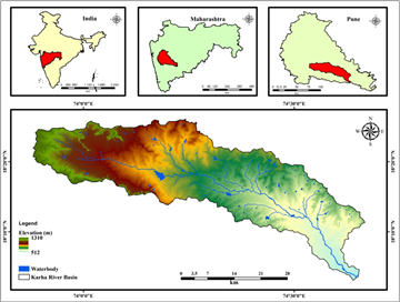
Karha river basin is selected for the research work. Karha drainage basin is located in Sahyadri mountain range in the southern part of Pune District. The Karha River is one of the major tributary of Nira River. Karha originates from the Askarwadi and make confluence with Nira at Songaon of Baramati Tehsil, Pune. The Malharsagar dam was erected upstream on the Karha river. The Karha River basin area extends from 18° 3’ 0” N to 18° 26’ 9” N latitude, 73° 52’53” E to 74° 40’00” E longitude and total catchments area is 1338 sq km (Figure 1).
The Karha river basin's elevation ranges from 512 to 1310 m. The study area is predominantly occupied by basaltic lava flows, which have limited porosity and permeability from a hydro-geological point of view. The Karha river basin is part of the Deccan trap and it is classified as a rain scarcity zone in the north-western ghats due to increased frequency of drought years. The average annual rainfall ranges 350–650 mm, with the monsoon season, which runs from June to September, accounting more than 80% of total rainfall. The study area is much dependent on rainfall for water availability to agricultural activities. In this region, agricultural irrigation is widely employed. Saswad, Jejuri, Kothale, Dhalewadi, Kodit Bk and Chabli are just a few of the small and large settlements in the study area. The Karha River is a seasonal river that only flows during the monsoon season, which last for four months. In the study region, there are various small water collection structures. The current iteration of the structures is the worst due to ignorance and poor care. Because of its semi-arid climate, this basin is only accessible during the monsoon. During the summer, nevertheless, the area faces a serious water scarcity problem, due to low rainfall mostly during non-monsoon season, the Karha river channel remains relatively dry 6.
To delineate the Karha river basin digital elevation model (DEM) data which has a 30-m resolution obtained from USGS earth explorer website to understand the slope of the area. The Karha river basin base map was created on a 1:50,000 scale using SOI topographical map with index (47 F/15, 47 F/16, 47 J/3, 47 J/4, 47 J/7, 47 J/8, 47 J/11, and 47 J/12). In ArcGIS 10.3, these SOI topographical maps were georeferenced with the WGS 84 datum and projected to the UTM zone 43 N projection.
Various aspects like Geomorphology, slope, geology, lineament density, drainage density, land use land cover, and soil texture were all considered in this study as influencing factors for groundwater recharge. Figure 2 shows the methodological flowchart used in this research. To generate thematic layers, multiple traditional data and geospatial data were obtained from various organizations and websites to identify various suitable zones of groundwater potential.
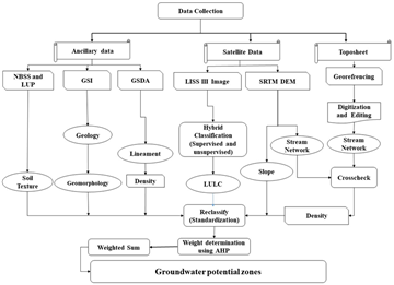
The stream network data was created using a topographic map of the basin at a resolution of 1:50,000. To cross-check the stream network, the stream network data was overlayed on the DEM. The Karha river basin's geomorphology and geological maps were obtained from the Geological Survey of India (GSI). The Groundwater Directorate of Surveys and Development Agency (GSDA) in Pune provided the lineament data. Using LISS III satellite images and ERDAS software, a hybrid classification method based on supervised and ISO clustered unsupervised classification was used to create a land use land cover map for the field of research. Soil data for the basin region was provided by the Indian government's National Bureau of Soil Survey and Land Use Planning (NBSS and LUP). All thematic layers were created using ArcGIS 10.3 software.
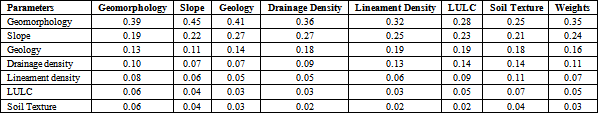
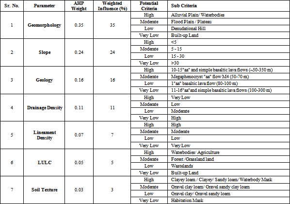
3.2. Analytic Hierarchy ProcessThe analytic hierarchy process (AHP) is a well-recognized multi-criteria technique that has been used in GIS-based analysis methods 7, 8 and is also a significant factor in the area of hazard management and environmental problems 9, 10, 11. The individual thematic map was reclassified in a raster image with a 30 m cell size. The AHP aids decision-making by combining multiple criteria into a pairwise comparison matrix 12. It produces the required weight factors using a preference matrix in which all related criteria are compared to one another using replicable preference factors, and after aggregating the weights of criterion for map layers 13. The AHP approach can be used to arrange both quantitative and qualitative information in decision-making analysis. Based on their relative relevance, each criterion was given a rank from 1 to 9. All of these factors have a relative scale for different criteria and preferences like (1 has equal importance; 3 has slight importance; 5 has quite an importance; 7 has extremely importance; 9 has absolutely importance and 2, 4, 6, and 8 are intermediate importance values). All the criteria are analyzed consequently using the AHP matrix.
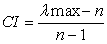
The pairwise comparison matrix of parameters for the groundwater potential zone (Table 1) shows that the hierarchical order is determined by their relative importance. To generate the standardized comparison matrix (Table 2) for groundwater potential zone mapping, pairwise comparison scores are standardized. The consistency ratio (CR) was intended to determine whether the pairwise comparisons metrics were reliable or not. Here, the strength of the AHP method is that it permits for varying relationships while providing a CR as an indicator of the grade of consistency or inconsistency 13, 14, 15. When the consistency ratio is less than 0.10, it suggests that the weights of the various criteria are quite consistent.
 | (1) |
 | (2) |
Where CI is specifying consistency index; RI is the random index, λ max is the principal Eigenvalue of a matrix; n refers to the number of parameters.
Random consistency index (RI) was assessed from a sample of “randomly generated reciprocal matrices” by 7. In the present study, the CR value is 0.06 indicating the appearances are of a good consistency for analysis of weights and suitable for delineating the groundwater potential zone.
Saaty 5 has been calculated the random consistency index (RI) from a sample of "randomly generated reciprocal matrices". The CR value for this study is 0.06, showing that the characteristics are consistent for weight analysis and suitable for identifying the groundwater potential zone. All of the variables were separated into four potential zones. Using the analytical hierarchy technique, different appropriateness criteria were assigned to each subgroup based on their relative relevance (Table 3).
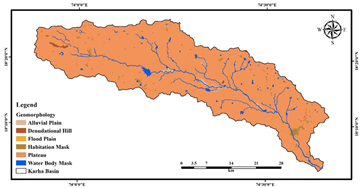
Geomorphology acts as the most essential factor in determining the occurrence, outlook, and movement of groundwater resources. The geomorphological development of a hard rock landscape takes place mainly due to tectonic activity and denudational processes. The Karha river basin has geomorphic features in it like: plateau, alluvial plain, denudational hill, flood plain, and water bodies (Figure 3). In the basin's Northwestern part, a dissected upper plateau has been seen. The massive pediment-peneplain composite, which is made up of weathered colluvium material or gravel and is present in the study area, acts as a possible groundwater recharge source. Because they have more surface runoff than recharge, the dissected plateau (Mesa and Butte) was assigned a lower mild weighted value. The floodplain of the study area is located in the eastern portion of the basin. Because of the high amount of alluvium deposits on a moderate slope, floodplains are frequently connected with good potentials. Since then, the water reservoir has been given the highest weighting; it serves as a significant source of groundwater recharge in the basin.
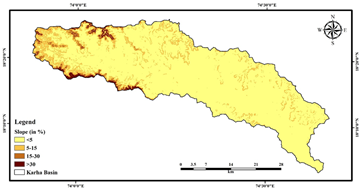
The slope or gradient is an important terrain element for the identification of GPZ. It has a direct impact on surface water infiltration. Flatter terrain is associated with a lower slope angle, while steeper terrain is associated with a higher slope angle. Because water runs quickly down steep slopes and precipitation does not have enough time to percolate, steep slopes have a poor recharge potential. In areas with moderate slopes, groundwater recharge can take longer. As a result, groundwater recharging occurs more frequently on moderate slopes as compared to on steeper slopes. A slope map of the Karha river basin was split into five categories depending on percentage (Figure 4), namely steep high (> 30), moderately (15-30), low (5-15), and very low (5) slopes. The majority of the basin is classified as having a moderate slope. The general implication is that steep to high slope classes dominate the basin's southwestern and north-western sections, making infiltration difficult.
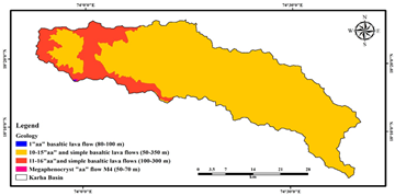
4.3. GeologyThe Karha river basin is a part of the Deccan Volcanic Province (DVP), which has multiple horizontal basaltic lava flows of various thicknesses. The study area characteristically consists of the Wai subgroup's Poladpur and Ambenali formations, and simple basaltic lava flows (50-350 m) (100-300 m) (Figure 5). The Poladpur formation (PF) is exposed towards the lowlands of Baramati in the south-east direction and is superimposed by the Ambenali formation (AF) in the north-western segment, which mainly covers the higher elevated regions (mostly Saswad and Jejuri) 16. The rocks are hydrogeological classified as hard rocks, having low porosity and permeability. The main apertures in basaltic flows, lava pipes, flow contacts, cavities, lava vesicles and tunnels, have low porosity and permeability. The porosity of the Ambenali formation is 1.2 %, according to the National Geophysical Research Institute (NGRI).
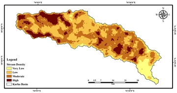
4.4. Drainage DensityThe proximity of channel spacing is used to calculate drainage density. In terms of function, a river basin's drainage density is the polar opposite of permeability. Higher drainage density leads to more runoff and less water infiltration into the subsurface, and vice versa 14. For drainage density, the Karha river basin has been categorized into four groups (Figure 6), very low, low, moderate, and high. The area under low to very low drainage density account for around 40.49% of the total basin area and have high weightage when compared with high drainage density zones.
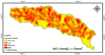
4.5. Lineament DensityLineaments refer to linear or curvilinear features on the earth surface that are line up expressions of an underlying lithological structures like a fault, fractures, or cleavages, etc. The major part of the Karha river basin is underlain by hard rocks, with lineaments which is providing secondary porosity and permeability, and which are significant for groundwater recharge. In the basin area, two main lineament orientations were observed: Northeast–Southwest and Northwest–Southeast tendencies. The density of lineaments in the Karha River basin has been classified as extremely low, low, moderate, and high (Figure 7). Groundwater development has a lot of potential in areas with a high lineament density.
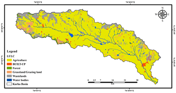
In the hydrological cycle, land use and land cover have a significant influence on hydro-geological and geo-hydroclimatic processes such as runoff, infiltration, evaporation, and transpiration. These processes have an impact on groundwater recharge. The six categories of land use-land cover in the Karha river basin are agriculture land, built-up land, forest, grassland, wasteland, and water bodies (Figure 8). Agriculture land takes up the largest acreage, accounting for 78.23% of the basin's total area. An extremely irrigated area was discovered near the Baramati as a result of the several lift irrigation systems applied in the region. The Nazare dam (Known as Malharsagar) which is on the Karha river near Jejuri is the principal water source for the study area. In the basin's extreme eastern portion, a significant settlement patch was identified. Water bodies cover around 28.72 sq. km (2.14 %) of the land area, while built-up land areas only cover 24.70 sq. km (1.84 %). Buildup aids groundwater percolation, while rocky wasteland is associated with low groundwater potentiality.
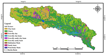
Soil is an important geomorphic element in determining the GPZ. Soil plays a crucial role in regulating runoff and infiltration rates. The permeability of soil is determined by its effective porosity, which is influenced by soil texture, voids ratio, structure, and saturation level. The soil texture of the Karha river basin is mostly composed of the following groups: clay loam, clayey, sandy loam, and water body mask, gravel clay loam, gravel sandy, clay loam gravel clay, gravel sandy loam, and habitation mask (Figure 9). Strong weightage readings in clay loam, clayey, sandy loam indicate a high groundwater potential.
The thematic layers are categorized into four groups based on its groundwater potentiality: excellent, good, moderate, and poor groundwater potential zone. Each class of a certain thematic layer has been assigned a suitable weighting on a scale of '4-1' based on their contribution to groundwater potentiality. Each thematic map was given a percentage of influence based on its contribution to groundwater. On all thematic layers, the weighted influence assigned to various classes is displayed in (Table 1). All of the thematic maps were integrated into one; with the use of the weighted overlay index technique and final groundwater potential map (Figure 10) was created.
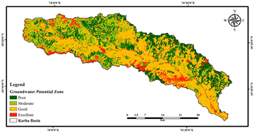
The alluvial plain, high intensity of lineament, area characterized by relatively soft slopes, geologically complicated gneiss, reserved forest, forest plantation and escarpments (LULC), clayey loam soil, and high drainage density all help to facilitate excellent ground water potential zone which is covers 8.33% area. The establishment of good GPZ has been aided by a very gentle slope, a significant number of lineaments, and the presence of very high quantities of megapenocyst 'aa' flow, plateau, gravel sandy soil, and moderate drainage density is cover 46.52% area and this is the maximum groundwater potential zone. Moderate GPZ is comprising moderate slope, scrub or wasteland land, and low drainage density promote moderate groundwater potential cover 19.36% area. We have a relatively soft slope, a low density of lineaments, and a low drainage density. Moderate ground water zones derive from these characteristics. Poor ground water potential zones covers moderate to strong slope, basaltic lava flow, and low lineament density, existence of plateau, built-up land and low drainage density and it comprises the 25.78% area.
Groundwater is considered a vital resource mainly in semi-arid and drought-prone areas. Groundwater is considered a primary resource of drinking water mainly in the semi-arid and drought-prone area. The Karha river basin is part of the semi-arid region, the area needs to explore groundwater potential zones. The use of AHP and geospatial techniques to define the groundwater potential zone (GPZ) in the Karha river basin. Geospatial technology has been proven to be effective in reducing time, costs, efficiency, and manpower allowing for proper groundwater resource management and development. The groundwater potential Zone map for the Karha river basin may help planners, scientists, and decision-makers monitor to manage groundwater resources. The present study shows how groundwater hydrogeological, geomorphological, and climatic properties are all interconnected. From high to very low, the basin is classified into four potential zones (Figure 10). GPZ has been shown to occur in almost every major town, including Saswad, Dorlewadi, Jalgaon, Loni Bhapkar, and Baramati. Using this easy and systematic procedure, groundwater potential areas can be delineated successfully. As a result, this approach can be utilized for groundwater exploration, artificial recharge zone identification, and long-term management of water resources everywhere in the world where there are hard rock aquifers and semi-arid climate conditions.
We are grateful to Savitribai Phule Pune University's Department of Geography for providing technical assistance for this research. The authors are thankful to the Ms. Nayan D. Zagade for the data collection and fieldwork. The authors also express gratitude to the anonymous reviewers for their constructive criticism and ideas, which helped to improve the manuscript's quality.
Authors declare that they have no competing interests.
| [1] | Waikar, M. L., and Nilawar, A. P. (2014). Identification of groundwater potential zone using remote sensing and GIS technique. International Journal of Innovative Research in Science, Engineering and Technology, 3(5), 12163-12174. | ||
| In article | |||
| [2] | Elango, K., and Mohan, S. (1997). Technical report on effectiveness of percolation ponds. Indian Institute of Technology Madras, Chennai, Submitted to Department of Science and Technology, New Delhi. | ||
| In article | |||
| [3] | Sitender and chaudhary, B.S. (2015). GIS apllicationin assessment and utilization of groundwaater resource in Haryana, India. International Journal of Advancement in Remote Sensing, GIS and Geography, 3(2): 26-35. | ||
| In article | |||
| [4] | Sitender and Rajeshwari, (2011). Delineation of groundwater potential zones in Mewat District, Haryana, India. Int J Geomatics Geosci, 2(1), 270-281. | ||
| In article | |||
| [5] | Saaty, T. L. (1990) How to make a decision: the analytic hierarchy process. Eur J Oper Res 48(1): 9-26. | ||
| In article | View Article | ||
| [6] | Kadam, A. K., Kale, S. S., Pande, N. N., Pawar, N. J., & Sankhua, R. N. (2012). Identifying potential rainwater harvesting sites of a semi-arid, basaltic region of Western India, using SCS-CN method. Water resources management, 26(9), 2537-2554. | ||
| In article | View Article | ||
| [7] | Saaty, T. L. (1980). The analytic hierarchy process-Planning priority setting resource Allocation. McGraw-Hill NY USA [M]. The Analytic Hierarchy Process: Planning, Priority Setting. Resource Allocation. | ||
| In article | |||
| [8] | Saaty, T. L., and Vargas, L. G. (1991). Prediction, projection and forecasting: applications of the analytic hierarchy process in economics, finance, politics, games and sports. Springer. | ||
| In article | View Article | ||
| [9] | Das, S. (2019). Comparison among influencing factor, frequency ratio, and analytical hierarchy process techniques for groundwater potential zonation in Vaitarna basin, Maharashtra, India. Groundwater for Sustainable Development. | ||
| In article | View Article | ||
| [10] | Badhe, Y., Medhe, R. and Shelar, T. (2019). Site Suitability Analysis for Water Conservation Using AHP and GIS Techniques: A Case Study of Upper Sina River Catchment, Ahmednagar (India) Hydrospatial Analysis, 3(2), 49-59. | ||
| In article | View Article | ||
| [11] | Badhe, Yogesh P., and Jaybhaye, Ravindra G. (2021). “Habitat Suitability Area Analysis for Leopard to Mitigate Human-Wildlife Conflict in Junnar Forest Division of Pune Forest Circle.” Applied Ecology and Environmental Sciences, vol. 9, no. 5: 524-542. | ||
| In article | View Article | ||
| [12] | Saaty, T.L. (1977). A Scaling Method for Priorities in Hierarchical Structures. Journal of Mathematical Psychology, 2 (12), 234-281. | ||
| In article | View Article | ||
| [13] | Chen, Y., Khan, S., and Paydar, Z. (2010). To retire or expand? A fuzzy GIS based spatial multi-criteria evaluation framework for irrigated agriculture. Irrigation and Drainage: The journal of the International Commission on Irrigation and Drainage, 59(2), 174-188. | ||
| In article | View Article | ||
| [14] | Bera, A., Mukhopadhyay, B. P., and Das, D. (2019). Landslide hazard zonation mapping using multi-criteria analysis with the help of GIS techniques: a case study from Eastern Himalayas, Namchi, South Sikkim. Natural Hazards, 96(2), 935-959. | ||
| In article | View Article | ||
| [15] | Feizizadeh, B., Blaschke, T., Nazmfar, H., and Rezaei Moghaddam, M. H. (2013). Landslide susceptibility mapping for the Urmia Lake basin, Iran: a multi-criteria evaluation approach using GIS. International Journal of Environmental Research, 7(2), 319-336. | ||
| In article | View Article | ||
| [16] | Beane, J. E., Turner, C. A., Hooper, P. R., Subbarao, K. V., and Walsh, J. N. (1986). Stratigraphy, composition and form of the Deccan basalts, Western Ghats, India. Bulletin of Volcanology, 48(1), 61-83. | ||
| In article | View Article | ||
Published with license by Science and Education Publishing, Copyright © 2022 Yogesh P. Badhe, Rajaram H. Choudhar and Tushar P. Raut
![]() This work is licensed under a Creative Commons Attribution 4.0 International License. To view a copy of this license, visit
http://creativecommons.org/licenses/by/4.0/
This work is licensed under a Creative Commons Attribution 4.0 International License. To view a copy of this license, visit
http://creativecommons.org/licenses/by/4.0/
| [1] | Waikar, M. L., and Nilawar, A. P. (2014). Identification of groundwater potential zone using remote sensing and GIS technique. International Journal of Innovative Research in Science, Engineering and Technology, 3(5), 12163-12174. | ||
| In article | |||
| [2] | Elango, K., and Mohan, S. (1997). Technical report on effectiveness of percolation ponds. Indian Institute of Technology Madras, Chennai, Submitted to Department of Science and Technology, New Delhi. | ||
| In article | |||
| [3] | Sitender and chaudhary, B.S. (2015). GIS apllicationin assessment and utilization of groundwaater resource in Haryana, India. International Journal of Advancement in Remote Sensing, GIS and Geography, 3(2): 26-35. | ||
| In article | |||
| [4] | Sitender and Rajeshwari, (2011). Delineation of groundwater potential zones in Mewat District, Haryana, India. Int J Geomatics Geosci, 2(1), 270-281. | ||
| In article | |||
| [5] | Saaty, T. L. (1990) How to make a decision: the analytic hierarchy process. Eur J Oper Res 48(1): 9-26. | ||
| In article | View Article | ||
| [6] | Kadam, A. K., Kale, S. S., Pande, N. N., Pawar, N. J., & Sankhua, R. N. (2012). Identifying potential rainwater harvesting sites of a semi-arid, basaltic region of Western India, using SCS-CN method. Water resources management, 26(9), 2537-2554. | ||
| In article | View Article | ||
| [7] | Saaty, T. L. (1980). The analytic hierarchy process-Planning priority setting resource Allocation. McGraw-Hill NY USA [M]. The Analytic Hierarchy Process: Planning, Priority Setting. Resource Allocation. | ||
| In article | |||
| [8] | Saaty, T. L., and Vargas, L. G. (1991). Prediction, projection and forecasting: applications of the analytic hierarchy process in economics, finance, politics, games and sports. Springer. | ||
| In article | View Article | ||
| [9] | Das, S. (2019). Comparison among influencing factor, frequency ratio, and analytical hierarchy process techniques for groundwater potential zonation in Vaitarna basin, Maharashtra, India. Groundwater for Sustainable Development. | ||
| In article | View Article | ||
| [10] | Badhe, Y., Medhe, R. and Shelar, T. (2019). Site Suitability Analysis for Water Conservation Using AHP and GIS Techniques: A Case Study of Upper Sina River Catchment, Ahmednagar (India) Hydrospatial Analysis, 3(2), 49-59. | ||
| In article | View Article | ||
| [11] | Badhe, Yogesh P., and Jaybhaye, Ravindra G. (2021). “Habitat Suitability Area Analysis for Leopard to Mitigate Human-Wildlife Conflict in Junnar Forest Division of Pune Forest Circle.” Applied Ecology and Environmental Sciences, vol. 9, no. 5: 524-542. | ||
| In article | View Article | ||
| [12] | Saaty, T.L. (1977). A Scaling Method for Priorities in Hierarchical Structures. Journal of Mathematical Psychology, 2 (12), 234-281. | ||
| In article | View Article | ||
| [13] | Chen, Y., Khan, S., and Paydar, Z. (2010). To retire or expand? A fuzzy GIS based spatial multi-criteria evaluation framework for irrigated agriculture. Irrigation and Drainage: The journal of the International Commission on Irrigation and Drainage, 59(2), 174-188. | ||
| In article | View Article | ||
| [14] | Bera, A., Mukhopadhyay, B. P., and Das, D. (2019). Landslide hazard zonation mapping using multi-criteria analysis with the help of GIS techniques: a case study from Eastern Himalayas, Namchi, South Sikkim. Natural Hazards, 96(2), 935-959. | ||
| In article | View Article | ||
| [15] | Feizizadeh, B., Blaschke, T., Nazmfar, H., and Rezaei Moghaddam, M. H. (2013). Landslide susceptibility mapping for the Urmia Lake basin, Iran: a multi-criteria evaluation approach using GIS. International Journal of Environmental Research, 7(2), 319-336. | ||
| In article | View Article | ||
| [16] | Beane, J. E., Turner, C. A., Hooper, P. R., Subbarao, K. V., and Walsh, J. N. (1986). Stratigraphy, composition and form of the Deccan basalts, Western Ghats, India. Bulletin of Volcanology, 48(1), 61-83. | ||
| In article | View Article | ||


