The Ébrié Lagoon, in the Grand-Bassam area, is exposed to various anthropogenic pressures that may alter is morphological and environnemental charactéristics. This study aims to characterize the morphobathymetric and hydrodynamic structures of this lagoon sector and to assess its physicochemical status. Bathymetric surveys provided 18,474 depth measurements, ranging from 0 to 19 m, over an area of approximately 42 ha. The results reveal two contrasting morphological units : a shallow southern channel characterized by relatively regular bottom topography, and a deeper northern basin reaching 18 to 19 m, with steep slopes and U-shaped and V-shaped cross-sectional profiles. These bathymetric features correspond to areas affected by dredging activities, as observed in the field and reported in previous studies. The distribution of surface currents shows heterogeneous flow directions and a convergence of water masses toward several steep-slope zones, with no dominant outflow toward the southern channel during the survey period. Physicochemical parameters were measured in situ at 33 sampling stations. Temperature, salinity, conductivity, and pH exhibited relatively low spatial variability, with mean values of 29.94 ± 0.30 °C, 1.75 ± 0.14‰, 29.30 ± 2.31 µS/cm, and 7.68 ± 0.10, respectively. In contrast, dissolved oxygen concentrations were very low, ranging from 0.10 to 0.40 mg/L, with a mean value of 0.23 ± 0.07 mg/L, indicating severe hypoxic conditions during the survey. The spatial association between the deep depression, surface circulation patterns, and low dissolved oxygen concentrations suggests that bottom morphological modifications may contribute to reduced water renewal and promote oxygen depletion. However, since physicochemical measurements were collected during a single survey and at a depth of 0.5 m, they do not allow assessment of the persistence or seasonal variability of hypoxia. These findings highlight the importance of considering bottom morphology and hydrodynamic connectivity in the management of lagoon sectors affected by dredging activities.
Côte d’Ivoire hosts one of the largest lagoon systems in West Africa, extending for nearly 300 km along the Gulf of Guinea coastline and covering an estimated surface area of approximately 1,200 km² 1. Coastal lagoons are generally shallow water bodies separated from the ocean by natural barriers and characterized by varying degrees of exchange with marine waters 2. These environments constitute highly valuable ecosystems due to the diversity of habitats they support, including mangroves, salt marshes, and seagrass beds, as well as the numerous ecosystem services they provide to local communities 3.
Among these lagoon systems, the Ebrié Lagoon is exposed to various anthropogenic pressures that may alter its physical, chemical, and biological characteristics. Urban, industrial, and domestic discharges, particularly from the Abidjan metropolitan area, contribute significantly to the degradation of water and sediment quality 4, 5, 6. These pressures are compounded by activities such as sand mining, aquaculture, and tourism, which may locally modify the natural characteristics of the environment 5. Despite these constraints, the Ebrié Lagoon plays a major socio-economic role for surrounding communities. Fishing activities, in particular, constitute an important source of income and livelihood 7. Preserving its hydrodynamic and environmental functions therefore represents a major challenge, especially in areas experiencing morphological changes induced by human activities.
Consequently, characterizing bottom morphology is essential for understanding the functioning of lagoon ecosystems. Bathymetric variations can influence water circulation patterns, depth distribution, flow concentration zones, and, potentially, water renewal and oxygenation processes. The combined study of morphobathymetry, hydrodynamics, and physicochemical parameters provides valuable insights into the interactions between bottom structure and the environmental status of aquatic systems.
The Grand-Bassam sector, located in the eastern part of the Ebrié Lagoon and corresponding to the Comoé Estuary, is of particular interest because of the morphological changes observed since the permanent opening of its mouth in September 2023. This modification has altered exchanges between continental and marine waters, potentially affecting hydrosedimentary dynamics, bottom morphology, and water quality. The presence of deep areas associated with steep slopes raises important questions regarding the relationships between morphobathymetric characteristics, water circulation processes, and the distribution of physicochemical parameters within the water column.
The present study aims to characterize the morphobathymetric structures and hydro-environmental conditions of the Comoé Estuary at Grand-Bassam in the context of the permanent opening of its mouth. More specifically, it seeks to: (i) characterize bottom morphology and depth distribution; (ii) analyze the main hydrodynamic features of the system; and (iii) assess the spatial distribution of key physicochemical parameters, particularly dissolved oxygen, in order to evaluate the current environmental status of the estuary.

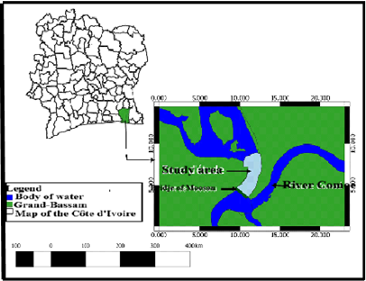
The Ebrié Lagoon is the largest coastal lagoon in Côte d’Ivoire. It covers an area of approximately 566 km² and extends over a distance of 130 km along an east-west axis, with a maximum width of 7 km. Its average depth is 4.8 m, reaching up to 20 m in the deepest channel sections. The lagoon is connected to the Atlantic Ocean through the Vridi Canal, a permanent artificial inlet, and the Bassam mouth 8. The study area is located in the eastern part of the Ebrié Lagoon, within the Grand-Bassam Department, in southeastern Côte d’Ivoire (Figure 1). It is centered approximately at 5°13′29″ N latitude and 3°43′02″ W longitude. The study site extends about 1,251 m northward from the Moossou Bridge, with a maximum width of approximately 338 m, covering an estimated area of 42 ha. The area is bounded to the south by the Moossou Bridge, to the east by the Comoé River, and to the west by the town of Moossou.
2.2. MaterialsBathymetric surveys were conducted onboard a motorized boat equipped with a LOWRANCE ELITE echo sounder coupled with an integrated GPS receiver. The transducer, mounted on the vessel's hull using a metal pole, was used to transmit and receive acoustic signals required for depth measurements. The integrated GPS continuously recorded the geographic coordinates associated with each measurement. The acquired bathymetric data were processed using Surfer 11, which was employed for point data interpolation, Digital Terrain Model (DTM) generation, and bathymetric map production. QGIS 2.18 was used for spatial data processing and cartographic mapping. Graphs and figures were produced using appropriate office software.
Physicochemical parameters were measured in situ using a PCE-PHD 1 multiparameter probe equipped with two electrodes. Water samples were also collected manually at each sampling station using dedicated containers. Geographic coordinates and water temperature were automatically recorded during field operations.
2.3. MethodsDepth determination using an echo sounder is based on the principle of acoustic wave propagation through the water column. The transducer emits an acoustic pulse toward the bottom. The wave travels through the water, is reflected at the water-sediment interface, and returns to the transducer, which also serves as a receiver. Water depth is calculated from the two-way travel time of the acoustic signal according to the following equation :
d = (c × t) / 2 (Equation 1)
Where c represents the speed of sound in water and t is the total travel time required for the acoustic signal to travel to the bottom and back. Measurement accuracy depends largely on sound velocity in water, which is itself influenced by temperature, salinity, and pressure 9
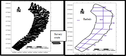
Considering that the study area covers less than 50 ha, a spacing of 25 m between survey transects was adopted in accordance with recommendations provided in the bathymetric survey standardization guide 10. A closer spacing may be required in areas exhibiting significant morphological variability in order to better represent bottom topography. The bathymetric survey was conducted on 28 February 2026 aboard a motorized boat following 10 transects oriented approximately perpendicular to the shoreline in order to ensure adequate coverage of the study area. A total of 18,474 bathymetric measurements were recorded (Figure 2). The data were subsequently corrected by accounting for the transducer immersion depth, estimated at 30 cm.

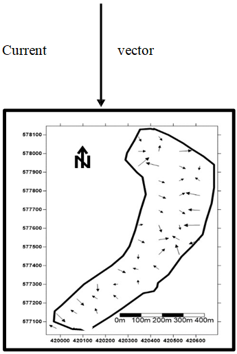
Surface flow directions were characterized using two complementary approaches. First, the bathymetric data collected throughout the study area were processed using Surfer 11 software. Based on the spatial distribution of depths and bottom topography, the vector generation tool was used to produce a vector representation of the inferred flow directions across the study area. This representation covers the entire Grand-Bassam sector, extending from the various bathymetric measurement points to the northernmost point located near the Moossou Bridge. Second, the inferred flow directions were compared with direct field observations. Visual observations of water mass movement were conducted between 12:00 and 13:00, when the flood tide was already underway. The direction of water movement was observed at several locations within the study area by members of the research team and confirmed by the boat operator. He indicated that marine waters were moving landward toward the lagoon during the observation period, which was consistent with the flow directions observed in the field. This approach made it possible to characterize the general direction of surface flows; however, it did not allow for the quantitative determination of flow velocity. No instrumental measurements of current velocity were carried out during this survey.
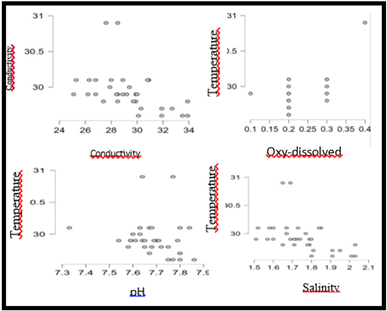
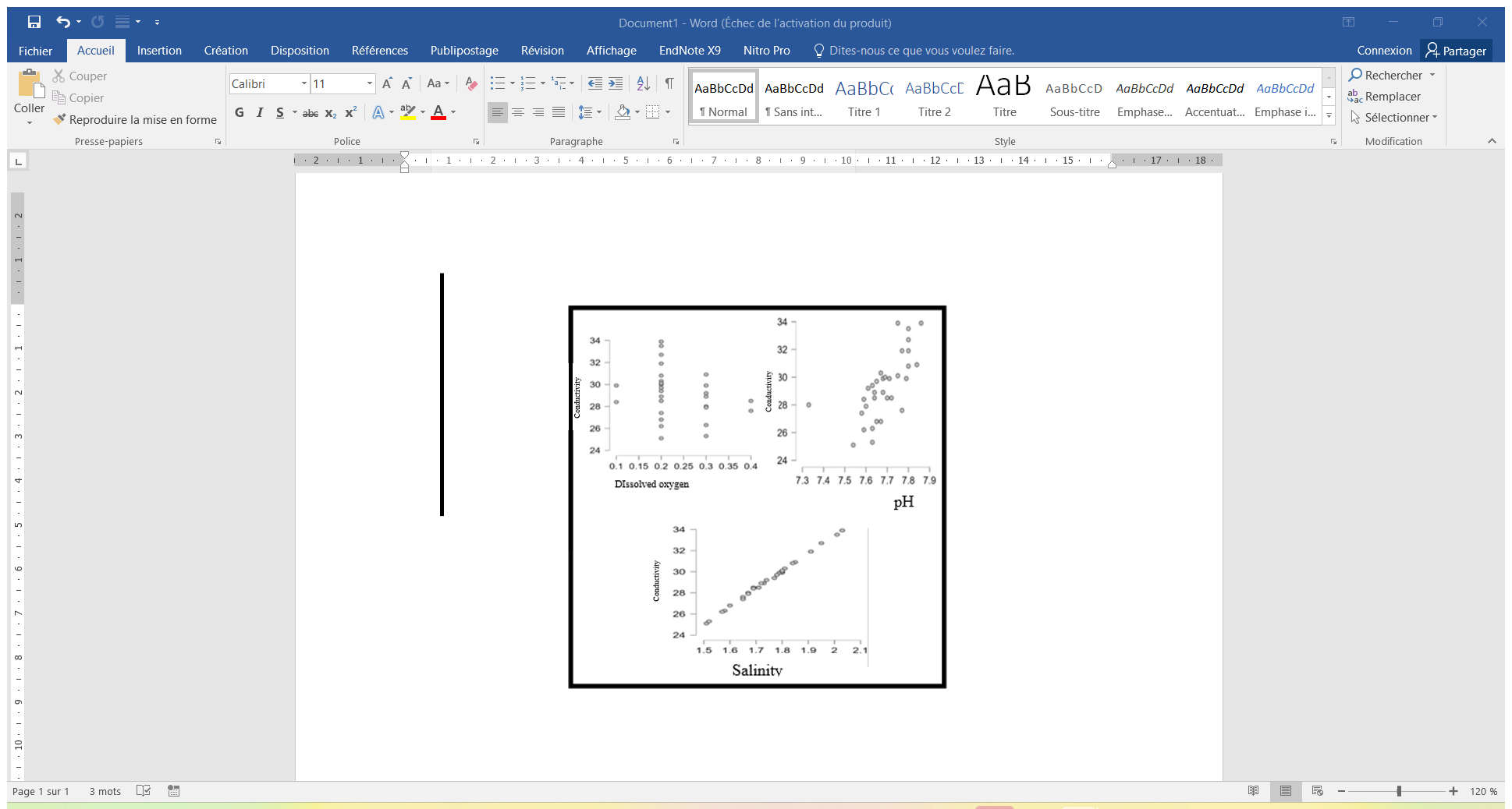
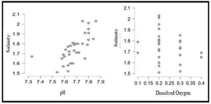
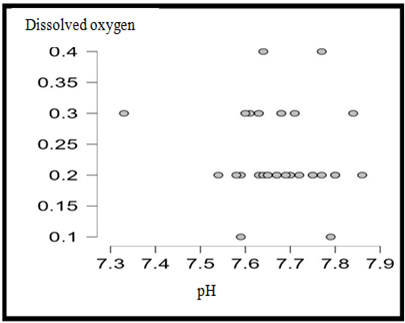
Physicochemical parameters were measured in situ on 28 February 2026, between 12:24 and 13:32, at 33 sampling stations and at a depth of 0.5 m, using a PCE-PHD 1 multiparameter probe. The parameters investigated included pH, electrical conductivity, salinity, and dissolved oxygen. Water temperature and geographic coordinates were recorded simultaneously during field operations. The collected data were analyzed using descriptive statistics, including the mean, standard deviation, minimum and maximum values, coefficient of variation, and skewness coefficient. The spatial distribution of the measured parameters was represented through thematic maps. Relationships among physicochemical parameters were investigated using scatter plots and a Pearson correlation matrix, generated with JASP software. These analyses were used to identify potential associations between water quality variables and to assess the main environmental gradients within the study area.
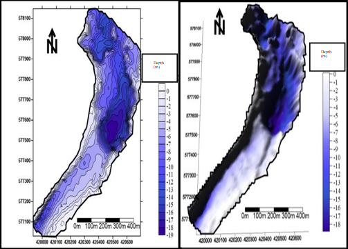
The bathymetric survey (1 m contour interval ; depths ranging from 0 to 19 m) revealed a heterogeneous bottom morphology (Figure 3), organized into two distinct units. In the northern part of the study area, a deep depression basin reaches depths of 18 to 19 m and is characterized by a steep western margin and a more gradual eastern margin. In contrast, the southern sector consists of a narrow southwest-northeast-oriented lagoon channel with a relatively flat and homogeneous bottom, as confirmed by the three-dimensional representation. This bathymetric anomaly observed in the northern basin, which greatly exceeds the average depth of the Ebrié Lagoon (4.8 m), cannot be attributed solely to natural fluvial erosion. Rather, it is likely the result of intensive sand dredging activities, which have major environmental consequences, including bank destabilization, destruction of benthic habitats, degradation of mangrove ecosystems, increased drowning risks, landscape alteration, and the resuspension of potentially contaminated sediments. Conversely, the regular morphology of the southern channel reflects a sedimentary regime dominated by sediment transport processes, with no significant anthropogenic disturbance.

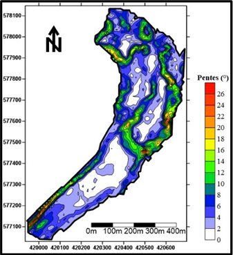
The vector representation of surface flows highlights spatially heterogeneous flow directions within the study area (Figure 5). In the northern basin, the vectors exhibit a tendency to converge toward specific sectors characterized by significant variations in bottom slope (Figure 4). In the southern channel, no dominant downstream flow orientation toward the marine outlet was observed during the survey period. This configuration can be interpreted in light of the hydrodynamic conditions prevailing at the time of observation. Measurements were conducted during the flood tide phase, between 12:00 and 13:00, when marine waters were flowing landward into the lagoon. The reduced discharge of the Comoé River during the dry season may also have contributed to this flow pattern. Field observations were generally consistent with the vector representation derived from the bathymetric data. However, these results primarily describe the flow directions observed during the survey and do not provide information on current velocities or their variability throughout the tidal cycle.


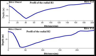
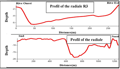
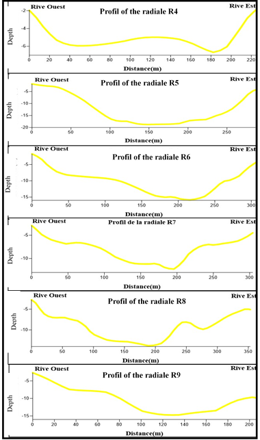
Ten survey transects (R1-R9, transverse O-E profiles ; R10, longitudinal profile) allowed the identification of three types of morphological profiles, each associated with a specific hydrosedimentary regime.
V-shaped profile (R1, R2), corresponding to an erosion-transport regime (Figure 6). These asymmetrical profiles result from the preferential action of fluvial and tidal currents, which erode one bank while transporting sediments downstream. This regime is further intensified by dredging activities, which disrupt the natural hydrodynamic equilibrium of the system.
The U-shaped profile (R4 to R9) corresponds to a transport-deposition regime (Figure 7). Transect R4 exhibits a double depression, indicating an advanced stage of sediment accumulation. Transects R5 to R9 display a flat bottom bordered by steep sidewalls, which is characteristic of successive excavation phases resulting from dredging activities. Unlike natural depressions, whose profiles generally exhibit smoother slopes, the succession of U-shaped profiles from R4 to R9 provides clear evidence of the considerable spatial extent of dredging operations within the study area.
The intermediate profile (R3, R10) reflects a transitional state between erosion-transport and transport-deposition regimes. Along R10, the southern section is characterized by advanced sediment infilling, whereas the central depression, marked by an abrupt drop from −8 m to −19 m, remains an active erosion zone tending toward a V-shaped morphology (Figure 8). The gradual rise in bottom elevation toward the northern sector indicates an area where erosion and sediment deposition coexist without a clear dominance of either process. This profile thus reflects a dynamic and unstable environment in which hydrosedimentary processes continuously interact.


Descriptive statistical analysis (Table 1) of the five physicochemical parameters measured at the 33 sampling stations revealed contrasting patterns. Temperature, pH, salinity, and conductivity exhibited low spatial variability, with coefficients of variation ranging from 0.010 to 0.079. Temperature showed a marked positive skewness, whereas pH displayed a moderate negative skewness. Dissolved oxygen differed from the other parameters by exhibiting the highest variability, with a coefficient of variation of 0.297. Measured concentrations ranged from 0.10 to 0.30 mg/L, with a mean value of 0.23 ± 0.07 mg/L, indicating extremely poor oxygenation conditions throughout the study area. Such concentrations are characteristic of severe hypoxic conditions that may adversely affect aquatic organisms and ecosystem functioning. Table 2 presents the main correlations among the investigated parameters. Conductivity and salinity showed an almost perfect positive correlation (r = 0.999). pH was positively correlated with salinity (r = 0.674) and conductivity (r = 0.670). Temperature showed a positive correlation with dissolved oxygen (r = 0.700) and moderate negative correlations with salinity (r = −0.455) and conductivity (r = −0.440). Dissolved oxygen exhibited weak correlations with pH (r = −0.160), salinity (r = −0.237), and conductivity (r = −0.237) (Figure 9-Figure 12).


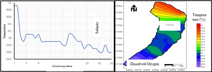
Water temperature ranged from 29.6 to 30.9°C, corresponding to a total variation of 1.3°C. The highest values (30.9°C) were recorded at Stations 1 and 2, whereas the lowest temperatures (29.6-29.8°C) were observed in the southern channel. The spatial distribution therefore reveals a decreasing thermal gradient from north to south (Figure 13). This pattern may be related to local hydrodynamic conditions, particularly the intrusion of relatively cooler marine waters into the southern part of the study area during the flood tide. In addition, differences in water depth and circulation may influence the spatial distribution of temperature. Since measurements were carried out between 12:24 and 13:32, the recorded values reflect surface thermal conditions prevailing during this specific period.

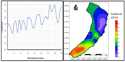
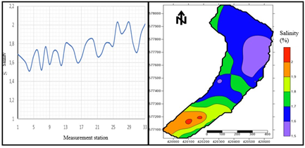
Conductivity ranged from 25.1 to 33.9 µS/cm (Figure 14), whereas salinity varied between 1.51 and 2.03 ‰ (Figure 15). Both parameters exhibited similar spatial patterns, characterized by a progressive increase from Station 1 toward the southern part of the study area. This distribution reflects the increasing influence of marine waters in the downstream sector during the flood tide period. The strong spatial correspondence between conductivity and salinity is consistent with the nearly perfect positive correlation observed between these variables (r = 0.999), confirming that water mineralization is primarily controlled by salinity variations associated with marine intrusion. The relatively low salinity values nevertheless indicate brackish conditions resulting from the mixing of continental and marine waters within the estuarine system.


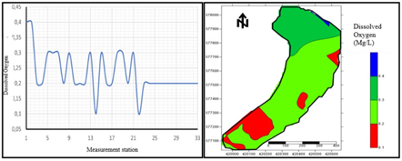
Dissolved oxygen concentrations ranged from 0.10 to 0.40 mg/L, with a mean value of 0.233 ± 0.069 mg/L. The highest concentration (0.40 mg/L) was recorded at Stations 1 and 2 in the northern basin. Concentrations then decreased at Stations 3 and 4, reaching 0.19 mg/L and 0.20 mg/L, respectively, before fluctuating between 0.20 and 0.30 mg/L up to Station 22. Beyond this station, dissolved oxygen levels remained relatively stable at approximately 0.20 mg/L through Station 33. Two minimum values of 0.10 mg/L were recorded at Stations 14 and 22.
The spatial distribution highlights a generally low level of oxygenation throughout the study area, with most stations exhibiting dissolved oxygen concentrations close to 0.20 mg/L (Figure 16). These values indicate a condition of severe hypoxia, reflecting environmental conditions that are unfavorable for many aquatic organisms. This situation may result from a combination of factors, including high organic matter loading, limited water circulation in certain sectors, and intense biological degradation processes that consume the available oxygen within the water column. The relative homogeneity of the low dissolved oxygen concentrations suggests that oxygen depletion affects the entire study area.

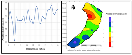
The pH ranged from 7.33 to 7.86, with a mean value of 7.684 ± 0.104. The lowest value (7.33) was recorded at Station 5. The spatial distribution highlights an area of relatively low pH values in the western part of the northern basin, whereas most stations exhibited values ranging from 7.52 to 7.72. Higher pH values were locally observed in the eastern part of the basin and along the southern channel (Figure 17). Overall, the measured pH values indicate a slightly alkaline environment throughout the study area. The relatively limited spatial variability of pH is consistent with its low coefficient of variation (CV = 0.014) and suggests relatively homogeneous acid-base conditions within the estuarine waters. The occurrence of higher pH values in some sectors may be associated with increased marine influence, as evidenced by the positive correlations observed between pH, salinity, and conductivity. Conversely, lower values may reflect localized inputs of continental waters or the influence of organic matter degradation processes.
The diversity of bathymetric profiles observed in the Grand-Bassam sector is consistent with the findings reported by 11 in the Ebrié Lagoon. The V-shaped profiles identified in the southern channel are characteristic of a sector subjected to active erosion and sediment transport processes driven by tidal currents and riverine inputs, in agreement with the interpretation proposed by 8.
In contrast, the northern basin is characterized by significantly greater depths, reaching 18 to 19 m, relatively steep slopes, and predominantly U-shaped profiles. These morphological features are similar to those described in several sectors of the Ebrié Lagoon affected by dredging and sand extraction activities 12, 13, 14. In the study area, the combination of considerable depths, U-shaped cross-sections, and steep slopes suggests a probable anthropogenic origin of these bathymetric features. This hypothesis is further supported by the presence of numerous urban developments and infrastructures in the Grand-Bassam area, which may have increased the demand for construction materials obtained through sand extraction. However, in the absence of detailed historical records documenting dredging operations, the exact contribution of these activities cannot be established with certainty and requires further investigation.
The bathymetric configuration observed is of particular interest for interpreting water circulation patterns recorded during the survey. The convergence of flow directions toward certain steep-slope areas may indicate an influence of bottom morphology on the local organization of water movements. However, as the flow directions were derived from bathymetric data processing and complemented by visual observations conducted during the flood-tide phase, they mainly describe the hydrodynamic conditions prevailing at the time of the survey. Consequently, they do not, by themselves, allow a quantitative assessment of hydrodynamic exchanges or current velocities.
4.2. Physicochemical ParametersThe recorded temperatures and their spatial distribution are generally consistent with the thermal characteristics previously reported for the Ebrié Lagoon 1, 4, 12, 15. Temperature exhibited low spatial variability during the survey. The positive correlation observed between temperature and dissolved oxygen (r = 0.700) is nevertheless noteworthy, as increasing temperature generally reduces oxygen solubility in water. This relationship may be associated with local biological processes, particularly the photosynthetic activity of aquatic macrophytes, as reported in some lagoon environments 16, 17. This interpretation should, however, be considered cautiously because of the instantaneous nature of the measurements and the absence of direct assessments of photosynthetic activity.
Conductivity and salinity exhibited similar spatial distributions and an almost perfect positive correlation (r = 0.999), reflecting their close relationship within the study area. These findings are consistent with observations reported by 18, 19 in the Ebrié Lagoon. The spatial patterns observed are likely influenced by exchanges between lagoon and marine waters, as well as by continental inputs. Urban discharges may also contribute to variations in conductivity and overall water chemistry 20. The most remarkable result concerns dissolved oxygen concentrations, which ranged from 0.10 to 0.40 mg/L across the 33 sampling stations. These values indicate extremely poor oxygenation conditions during the survey and are comparable to those reported in heavily impacted sectors of the Ebrié Lagoon 4, 13, 14, 19, 21. Several factors may explain these low dissolved oxygen concentrations. Inputs of domestic and urban organic matter can increase oxygen demand through the decomposition of organic material. In addition, the particular morphobathymetric configuration of the northern basin and the flow patterns observed during the survey may locally limit water renewal. Stratification and eutrophication processes may also influence dissolved oxygen dynamics in lagoon environments 16, 17. In the study area, therefore, low oxygen concentrations appear to result from the combined action of several interacting factors rather than a single controlling mechanism.
These low oxygen levels may have significant consequences for aquatic organisms and ecosystem functioning. The studies of 6, 7 highlight the environmental degradation affecting the Ebrié Lagoon and its implications for economic activities and natural resources that depend on this ecosystem.
Finally, pH values remained close to neutral to slightly alkaline conditions. The lowest values may be associated with organic matter degradation and CO₂ production in areas experiencing limited water renewal. Nevertheless, this interpretation remains hypothetical, as the available data do not allow the direct identification of the biochemical processes responsible for the observed spatial variations 4, 19, 20
This study provided a characterization of the morphobathymetry, surface flow directions, and main physicochemical properties of the Grand-Bassam sector of the Ebrié Lagoon. The bathymetric results revealed two distinct morphological configurations. The southern channel is characterized by relatively shallow depths and V-shaped profiles, whereas the northern basin exhibits a much deeper depression, reaching 18 to 19 m, associated with U-shaped profiles and relatively steep slopes. These morphological features suggest a sector that has been significantly modified by anthropogenic activities, although the exact contribution of dredging operations requires further documentation and historical evidence. The analysis of surface flow directions highlighted a spatial organization of water movements that appears to be locally influenced by bottom morphology. In the northern basin, a convergence of flow directions toward steeply sloping areas was observed. Field observations conducted during the flood-tide phase were generally consistent with this pattern. However, in the absence of direct measurements of current velocity, the results primarily describe flow directions at the time of the survey and do not allow a quantitative assessment of hydrodynamic exchanges. From a physicochemical perspective, temperature, pH, salinity, and conductivity exhibited relatively low spatial variability, whereas dissolved oxygen showed greater variability. Dissolved oxygen concentrations, ranging from 0.10 to 0.40 mg/L across the 33 sampling stations, indicate severe hypoxic conditions throughout the study area. These low concentrations are likely the result of the combined influence of several factors, including organic matter inputs, the morphobathymetric configuration of the northern basin, local water circulation patterns, and biological processes affecting oxygen dynamics. Overall, the results demonstrate that the morphological characteristics of the study area play an important role in controlling water circulation and shaping the observed physicochemical conditions. They also highlight the environmental vulnerability of this sector of the Ebrié Lagoon, particularly with regard to its extremely low dissolved oxygen levels. Further investigations, including surveys conducted during different tidal stages and seasons, together with direct measurements of current velocity, sediment dynamics, and water quality, would improve understanding of water renewal processes and their influence on ecosystem functioning. Such studies would also provide valuable information for the sustainable management and conservation of the Grand-Bassam estuarine environment.
GPS Global Positioning System
DTM Digital Terrain Model
This study received material and financial support from the Department of Mining and Reservoirs at the University of Man
| [1] | Varlet F. (1978). The Hydrological Regime of the Ébrié Lagoon (Côte d'Ivoire): Essential Physical Characteristics. ORSTOM Works and Documents Series, No. 83, Paris, France, 164 p. | ||
| In article | |||
| [2] | Kennish M.J. & Paerl H.W. (2010). Coastal Lagoons : Critical Habitats of Environmental Change. CRC Press, Boca Raton, Florida, USA, 576 p. | ||
| In article | View Article PubMed | ||
| [3] | Newton A., Brito A.C., Icely J.D., Derolez V., Clara I., Angus S. & Khokhlov V. (2018). Assessing, Quantifying and Valuing the Ecosystem Services of Coastal Lagoons. Journal for Nature Conservation, 44, 50-65. | ||
| In article | View Article | ||
| [4] | Soro G., Metongo B.S., Soro N., Ahoussi K.E., Kouame K.F., Zade S.G.P. & Soro T. (2009). Heavy metals (Cu, Cr, Mn and Zn) in surface sediments of an African tropical lagoon : the case of the Ébrié Lagoon (Côte d'Ivoire). International Journal of Biological and Chemical Sciences, 3(6), 1408-1427. | ||
| In article | View Article | ||
| [5] | N'Guessan Y.A., Adopo K.L., Amani E.M., Konan K.B., Touré M., Monde S. & Aka K. (2013). Bathymetric, sedimentological and depositional environment study of surface sands in the Fresco Lagoon (western Ivorian coast). Journal of Asian Scientific Research, 3(3), 308-320. | ||
| In article | |||
| [6] | Gboudjou G.A., Adiko A.F. & Amani Y.C. (2022). Perceived impacts of pollution in the Ébrié Lagoon and mitigation and adaptation measures adopted by fishermen in the municipality of Koumassi (Abidjan, Côte d'Ivoire). Revue Africaine des Sciences Sociales et de la Santé Publique, 4(2), 108-120. | ||
| In article | |||
| [7] | Scheren P.A.G.M., Kroeze C., Janssen F.J.J.G., Hordijk L. & Ptasinski K.J. (2004). Integrated Water Pollution Assessment of the Ébrié Lagoon, Ivory Coast, West Africa. Journal of Marine Systems, 44, 1-17. | ||
| In article | View Article | ||
| [8] | Affian K. (2003). Environmental Approach to a Microtidal Lagoon Ecosystem (Ébrié Lagoon, Côte d'Ivoire) through Geochemical, Bathymetric and Hydrological Studies : Contribution of GIS and Remote Sensing. State Doctoral Thesis, University of Cocody, Abidjan, Côte d'Ivoire, 225 p. | ||
| In article | |||
| [9] | IHO (2011). Manual on Hydrography, Publication C-13, 1st Edition. International Hydrographic Bureau, Monaco, 540 p. | ||
| In article | |||
| [10] | MRNF - Ministry of Natural Resources and Wildlife (2011). Standardization Guide for Bathymetric Surveys. Wildlife Sector, Québec, Canada, 41 p. | ||
| In article | |||
| [11] | Diangone E., N'Guessan Y.A., Konan K.E., Boko A.J. & Monde S. (2019). Morphobathymetric characterization of the Adiopo-Doumé estuarine bay in the Ébrié Lagoon (Côte d'Ivoire). The International Journal of Engineering and Science, 8(1), 40-46. | ||
| In article | |||
| [12] | Monde S., Coulibaly A.S., Wango T.E. & Aka K. (2011). Hydrodynamics of the Ébrié Lagoon estuary (Côte d'Ivoire). Revue Paralia, 4, 5.1-5.14. | ||
| In article | View Article | ||
| [13] | Pottier P., Affian K., Djagoua M.V., Anoh K.P., Kra Y., Kangah A. & Robin M. (2008). The Ébrié Lagoon under anthropogenic pressure. In: Risques côtiers et gestion intégrée des territoires littoraux. University of Nantes Publications, Nantes, France, pp. 1-18. | ||
| In article | |||
| [14] | Aka A.M., Kouamé A.F., Aka C.A. & Coulibaly A.S. (2020). Hydrological and morpho-sedimentary characterization of a dredging area in the Ébrié Lagoon and contamination risks for the Abidjan aquifer: case of the Abatta-Bingerville lagoon sector. Revue Internationale de Recherche Scientifique et de Gestion, 8(8), 1572-1587. | ||
| In article | View Article | ||
| [15] | Durand J.R. & Guiral D. (1994). Hydroclimate and hydrochemistry. In : Environnement et Ressources Aquatiques de Côte d'Ivoire. Tome II, Milieux lagunaires. ORSTOM Editions, Paris, France, pp. 59-90. | ||
| In article | |||
| [16] | Wetzel R.G. (2001). Limnology : Lake and River Ecosystems (3rd Edition). Academic Press, San Diego, California, USA, 1006 p. | ||
| In article | |||
| [17] | Guiral D., Arfi R. & Torreton J.P. (1989). Mechanisms and ecological impacts of annual density homogenization in a stratified eutrophic environment. Hydrobiologia, 183, 195-210. | ||
| In article | View Article | ||
| [18] | Kouassi A.M., Tidou A.S. & Kamenan A. (2009). Hydrochemical and microbiological characteristics of Ébrié Lagoon waters (Côte d'Ivoire). Part I: Seasonal variability of hydrochemical parameters. Agronomie Africaine, 17(2), 117-136. | ||
| In article | View Article | ||
| [19] | Kpannieu D.E., Kouadio K.N., M'Bra I.C., Hippolyte C.N., Coulibaly L. & Ouffouet S. (2022). Physico-Chemical Pollution and Trophic State of Biétry Bay (Ébrié Lagoon, Abidjan, Ivory Coast). Journal of Materials Science and Chemical Engineering, 10(2), 87-99. | ||
| In article | View Article | ||
| [20] | Togbé A.M.O., Kouamé V.K., Yao K.M., Ouattara A.A., Tidou A.S. & Atsé B.C. (2019). Assessment of arsenic, lead and cadmium contamination in the waters of the Ébrié Lagoon (Zones IV and V): spatio-temporal variations and health risks. International Journal of Biological and Chemical Sciences, 13(2), 1162-1179. | ||
| In article | View Article | ||
| [21] | Yao K.M., Métongo B.S., Trokourey A. & Bokra Y. (2007). Determination of selected pollution parameters in the bays of a tropical lagoon : the Ébrié Lagoon (Côte d'Ivoire). Journal Ivoirien d'Océanologie et de Limnologie, 4, 1-10. | ||
| In article | |||
Published with license by Science and Education Publishing, Copyright © 2026 KOFFI Épouse COULIBALY Chiayé Larissa, PAN Pekpenin Benjamin Patrick, Ouattara Ismaël Ben and MONDE Sylvain
 This work is licensed under a Creative Commons Attribution 4.0 International License. To view a copy of this license, visit
http://creativecommons.org/licenses/by/4.0/
This work is licensed under a Creative Commons Attribution 4.0 International License. To view a copy of this license, visit
http://creativecommons.org/licenses/by/4.0/
| [1] | Varlet F. (1978). The Hydrological Regime of the Ébrié Lagoon (Côte d'Ivoire): Essential Physical Characteristics. ORSTOM Works and Documents Series, No. 83, Paris, France, 164 p. | ||
| In article | |||
| [2] | Kennish M.J. & Paerl H.W. (2010). Coastal Lagoons : Critical Habitats of Environmental Change. CRC Press, Boca Raton, Florida, USA, 576 p. | ||
| In article | View Article PubMed | ||
| [3] | Newton A., Brito A.C., Icely J.D., Derolez V., Clara I., Angus S. & Khokhlov V. (2018). Assessing, Quantifying and Valuing the Ecosystem Services of Coastal Lagoons. Journal for Nature Conservation, 44, 50-65. | ||
| In article | View Article | ||
| [4] | Soro G., Metongo B.S., Soro N., Ahoussi K.E., Kouame K.F., Zade S.G.P. & Soro T. (2009). Heavy metals (Cu, Cr, Mn and Zn) in surface sediments of an African tropical lagoon : the case of the Ébrié Lagoon (Côte d'Ivoire). International Journal of Biological and Chemical Sciences, 3(6), 1408-1427. | ||
| In article | View Article | ||
| [5] | N'Guessan Y.A., Adopo K.L., Amani E.M., Konan K.B., Touré M., Monde S. & Aka K. (2013). Bathymetric, sedimentological and depositional environment study of surface sands in the Fresco Lagoon (western Ivorian coast). Journal of Asian Scientific Research, 3(3), 308-320. | ||
| In article | |||
| [6] | Gboudjou G.A., Adiko A.F. & Amani Y.C. (2022). Perceived impacts of pollution in the Ébrié Lagoon and mitigation and adaptation measures adopted by fishermen in the municipality of Koumassi (Abidjan, Côte d'Ivoire). Revue Africaine des Sciences Sociales et de la Santé Publique, 4(2), 108-120. | ||
| In article | |||
| [7] | Scheren P.A.G.M., Kroeze C., Janssen F.J.J.G., Hordijk L. & Ptasinski K.J. (2004). Integrated Water Pollution Assessment of the Ébrié Lagoon, Ivory Coast, West Africa. Journal of Marine Systems, 44, 1-17. | ||
| In article | View Article | ||
| [8] | Affian K. (2003). Environmental Approach to a Microtidal Lagoon Ecosystem (Ébrié Lagoon, Côte d'Ivoire) through Geochemical, Bathymetric and Hydrological Studies : Contribution of GIS and Remote Sensing. State Doctoral Thesis, University of Cocody, Abidjan, Côte d'Ivoire, 225 p. | ||
| In article | |||
| [9] | IHO (2011). Manual on Hydrography, Publication C-13, 1st Edition. International Hydrographic Bureau, Monaco, 540 p. | ||
| In article | |||
| [10] | MRNF - Ministry of Natural Resources and Wildlife (2011). Standardization Guide for Bathymetric Surveys. Wildlife Sector, Québec, Canada, 41 p. | ||
| In article | |||
| [11] | Diangone E., N'Guessan Y.A., Konan K.E., Boko A.J. & Monde S. (2019). Morphobathymetric characterization of the Adiopo-Doumé estuarine bay in the Ébrié Lagoon (Côte d'Ivoire). The International Journal of Engineering and Science, 8(1), 40-46. | ||
| In article | |||
| [12] | Monde S., Coulibaly A.S., Wango T.E. & Aka K. (2011). Hydrodynamics of the Ébrié Lagoon estuary (Côte d'Ivoire). Revue Paralia, 4, 5.1-5.14. | ||
| In article | View Article | ||
| [13] | Pottier P., Affian K., Djagoua M.V., Anoh K.P., Kra Y., Kangah A. & Robin M. (2008). The Ébrié Lagoon under anthropogenic pressure. In: Risques côtiers et gestion intégrée des territoires littoraux. University of Nantes Publications, Nantes, France, pp. 1-18. | ||
| In article | |||
| [14] | Aka A.M., Kouamé A.F., Aka C.A. & Coulibaly A.S. (2020). Hydrological and morpho-sedimentary characterization of a dredging area in the Ébrié Lagoon and contamination risks for the Abidjan aquifer: case of the Abatta-Bingerville lagoon sector. Revue Internationale de Recherche Scientifique et de Gestion, 8(8), 1572-1587. | ||
| In article | View Article | ||
| [15] | Durand J.R. & Guiral D. (1994). Hydroclimate and hydrochemistry. In : Environnement et Ressources Aquatiques de Côte d'Ivoire. Tome II, Milieux lagunaires. ORSTOM Editions, Paris, France, pp. 59-90. | ||
| In article | |||
| [16] | Wetzel R.G. (2001). Limnology : Lake and River Ecosystems (3rd Edition). Academic Press, San Diego, California, USA, 1006 p. | ||
| In article | |||
| [17] | Guiral D., Arfi R. & Torreton J.P. (1989). Mechanisms and ecological impacts of annual density homogenization in a stratified eutrophic environment. Hydrobiologia, 183, 195-210. | ||
| In article | View Article | ||
| [18] | Kouassi A.M., Tidou A.S. & Kamenan A. (2009). Hydrochemical and microbiological characteristics of Ébrié Lagoon waters (Côte d'Ivoire). Part I: Seasonal variability of hydrochemical parameters. Agronomie Africaine, 17(2), 117-136. | ||
| In article | View Article | ||
| [19] | Kpannieu D.E., Kouadio K.N., M'Bra I.C., Hippolyte C.N., Coulibaly L. & Ouffouet S. (2022). Physico-Chemical Pollution and Trophic State of Biétry Bay (Ébrié Lagoon, Abidjan, Ivory Coast). Journal of Materials Science and Chemical Engineering, 10(2), 87-99. | ||
| In article | View Article | ||
| [20] | Togbé A.M.O., Kouamé V.K., Yao K.M., Ouattara A.A., Tidou A.S. & Atsé B.C. (2019). Assessment of arsenic, lead and cadmium contamination in the waters of the Ébrié Lagoon (Zones IV and V): spatio-temporal variations and health risks. International Journal of Biological and Chemical Sciences, 13(2), 1162-1179. | ||
| In article | View Article | ||
| [21] | Yao K.M., Métongo B.S., Trokourey A. & Bokra Y. (2007). Determination of selected pollution parameters in the bays of a tropical lagoon : the Ébrié Lagoon (Côte d'Ivoire). Journal Ivoirien d'Océanologie et de Limnologie, 4, 1-10. | ||
| In article | |||