Rainfall variability in West Africa represents a major scientific issue due to its direct impacts on water resources, agriculture, and socio-economic systems. In Guinea, a country highly dependent on precipitation regimes, recent observations suggest a non-stationary evolution of the climate, characterized by alternating wet and dry phases as well as potential changes in rainfall patterns. In this context, the study aims to analyze the spatio-temporal variability of annual precipitation between 1986 and 2015 in order to identify and characterize the main climatic breakpoints across the Guinean territory. The study is based on high spatial resolution CHIRPS v2.0 satellite data (0.05°), aggregated into annual totals and then standardized using the Standardized Precipitation Index (SPI). The statistical analysis combines several complementary non-parametric change-point detection methods, including the Pettitt test, the Lee & Heghinian test, and Hubert segmentation, applied across the four natural regions of Guinea. This approach makes it possible to identify discontinuities in rainfall time series, assess their significance, and compare their spatial distribution according to regional climatic gradients. The results highlight strong interannual rainfall variability and the existence of a major climatic shift beginning in the mid-1990s, reflecting a reorganization of the rainfall regime. A second phase of change, observed between 1999 and 2015, reveals an asynchronous and spatially heterogeneous dynamic, with contrasting behaviors across the natural regions. Overall, an increase in interannual variability and an intensification of hydroclimatic extremes is observed. In conclusion, the Guinean climate appears to have undergone a profound restructuring, characterized by increasing instability of the precipitation system, underscoring the need to integrate these breakpoints into adaptation strategies and water resource management planning
Rainfall variability is one of the key features of the West African climate and represents a major scientific issue due to its environmental, hydrological, and socio-economic impacts. In West Africa, precipitation strongly governs agricultural activities, water resource availability, hydropower production, and the functioning of natural ecosystems (e.g. 1). In this region, where rainfed agriculture dominates production systems, any alteration in rainfall regimes can have significant consequences for food security and population livelihoods (e.g. 2).
Since the late 1960s, several studies have highlighted a profound shift in the West African rainfall regime, characterized by a marked decline in annual precipitation and the emergence of persistent droughts, particularly across the Sahelian belt (e.g. 3, 4). This dry period, considered one of the most severe of the twentieth century, has deeply affected regional hydrological and agricultural systems (e.g. 5). Hydroclimatic analyses in West Africa have shown that this rainfall decrease is not solely the result of a gradual trend, but also of abrupt changes in climatic time series, indicating the presence of rainfall breakpoints 6.
Climate breaks correspond to significant changes in the statistical properties of a time series, particularly in its mean or variance (e.g. 7). In hydroclimatology, their identification makes it possible to detect transitions between different climatic phases and to assess changes in precipitation regimes (e.g. 8). Several statistical methods, such as the (e.g. 7), the Lee and (e.g. 9), and Hubert’s segmentation approach (e.g. 6), are commonly used to analyze climatic discontinuities in African rainfall time series.
Moreover, Guinea is often referred to as the “water tower of West Africa” due to its significant hydrological potential and the presence of the headwaters of major regional rivers such as the Niger, Senegal, and Gambia. The country’s water resources are highly dependent on seasonal and interannual rainfall regimes. Consequently, any long-term change in precipitation patterns can have major impacts on river discharge, water availability, agriculture, and energy production (e.g. 10).
In recent decades, several climatic observations have revealed strong rainfall irregularity in Guinea, characterized by alternating periods of deficit and surplus precipitation. Some regions have experienced prolonged rainfall deficits, while others have recorded episodes of intense rainfall associated with recurrent flooding events (e.g. 11). This variability reflects the non-stationarity of annual rainfall series and suggests the existence of climatic breaks that may have durably altered the country’s hydroclimatic functioning.
Despite the importance of precipitation in Guinea’s environmental and socio-economic context, studies focusing on the spatio-temporal analysis of rainfall breaks remain limited. Existing research generally addresses climate trends or interannual rainfall variability without thoroughly investigating abrupt changes in time series. However, identifying break dates, their magnitude, and their spatial distribution is essential for a better understanding of recent climate evolution in Guinea.
The spatio-temporal analysis of annual rainfall breaks therefore constitutes an essential scientific tool for characterizing regional climate change. It not only highlights climatic transition periods but also allows comparisons of rainfall behavior across the country’s different natural regions. Such an approach contributes to improving knowledge of hydroclimatic dynamics and to better assessing risks associated with climate extremes.
Finally, in the context of intensifying global climate change, this study is part of ongoing scientific efforts to better understand recent climate evolution in West Africa. The identification of annual rainfall breaks in Guinea will enhance knowledge of regional climate dynamics and contribute to the development of appropriate strategies for natural resource management and climate risk reduction.
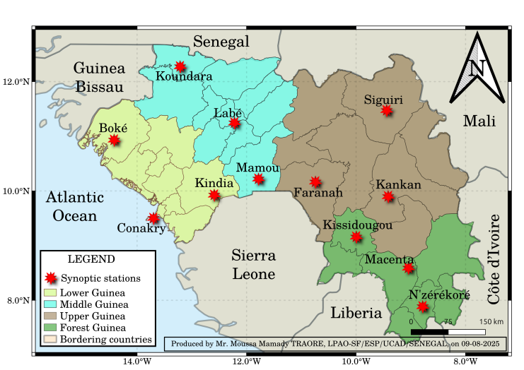
Figure 1 presents the study area. The Republic of Guinea is divided into four (4) natural regions, each characterized by distinct microclimatic conditions.
a. Lower Guinea or Maritime Guinea
Lower Guinea (LG) includes the synoptic stations of Boké, Conakry, and Kindia. This region is also known as Maritime Guinea due to its coastal location. It experiences a humid tropical climate, with rainfall reaching its maximum in August and exceeding 4000 mm/year in Conakry (e.g. 12).
b. Middle Guinea or Fouta Djallon
Middle Guinea (MG) comprises the synoptic stations of Koundara, Labé, and Mamou. It is the most mountainous region of the country, dominated by the Fouta Djallon massif, which covers about 80,000 km², with Mount Loura (1532 m) as its highest point. The rainy season lasts between 5 and 8 months from Koundara to Mamou, with annual rainfall below 1300 mm in the northern part of the region (e.g. 12, 13).
c. Upper Guinea
Upper Guinea (UG) includes the synoptic stations of Faranah, Kankan, and Siguiri. It is located between Forest Guinea and the Fouta Djallon, at the western edge of the large Niger River basin. Climatically, it is the driest region of Guinea, characterized by a Sudanian climate. Annual precipitation ranges between 1,200 and 1,800 mm. It also experiences the longest dry season (7 to 8 months), with relatively high mean temperatures throughout the year, reaching up to 40°C between March and April (e.g. 14).
d. Forest Guinea
Forest Guinea (FG) includes the synoptic stations of Kissidougou, Macenta, and N’Zérékoré. Its climate is sub-equatorial, with abundant and relatively regular rainfall distributed over approximately 8 to 9 months (e.g. 13). This region records a very high number of rainy days (e.g. 15). Mean annual rainfall ranges from 1,800 to 2,300 mm (e.g. 14). Temperatures remain mild throughout the year, averaging around 25°C.

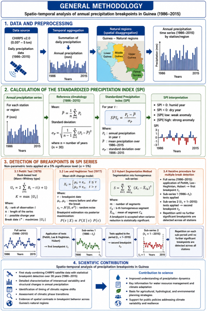
Figure 2 presents a robust and reproducible methodological framework designed to identify and characterize rainfall discontinuities in the Republic of Guinea over the 1986–2015 period through a structured four-step procedure. The first step (1) involves the acquisition of high-resolution satellite-based precipitation data (CHIRPS v2.0, 0.05° resolution). This dataset has been extensively validated across West Africa and shown to agree well with in situ observations, providing reliable estimates of rainfall variability and extremes. It is therefore well suited for climate variability and hydrological change analyses in Guinea. The data are then temporally aggregated into annual rainfall totals and spatially organized according to the country’s four natural regions, enabling the construction of consistent time series at both station and regional scales. In addition, the JAS season (July–August–September) is selected for breakpoint analysis because it corresponds to the core rainy season in West Africa, particularly in Guinea, where it concentrates the bulk of annual precipitation. This period represents the most climatically stable rainfall signal, minimizing the influence of transitional months and thereby improving the robustness of structural change detection.
The second step (2) consists of standardizing the precipitation datasets through the computation of the Standardized Precipitation Index (SPI), based on a 30-year reference climatology. This normalization procedure allows for the objective identification of wet and dry anomalies independently of absolute rainfall magnitudes, ensuring comparability across space and time.
The third phase (3) constitutes the statistical core of the methodology. It applies a suite of complementary non-parametric tests, including the Pettitt test (rank-based approach), the Lee & Heghinian Bayesian change-point model, and Hubert’s segmentation procedure, integrated into an iterative framework capable of detecting multiple and successive change points at a 5% significance level. The combined use of the Pettitt test, the Lee & Heghinian Bayesian change-point model, and Hubert’s segmentation method is justified by the need to ensure robust and reliable detection of change points in non-stationary and potentially noisy climate time series. The Pettitt test, a non-parametric rank-based approach, enables the detection of a single abrupt shift without distributional assumptions and is particularly robust to outliers. The Lee & Heghinian Bayesian model complements this approach by providing a probabilistic estimation of the change-point location, together with an explicit quantification of associated uncertainty, thereby improving the statistical interpretation of detected shifts. Finally, Hubert’s segmentation method allows an objective partitioning of the series into successive homogeneous regimes, making it suitable for identifying multiple breakpoints and revealing more complex temporal structures. The combination of these three methods therefore ensures cross-validation of results, reduces methodological bias, and enhances the robustness and reliability of identified climatic changes.
Finally, the fourth phase (4) translates these mathematical validations into concrete scientific outputs by revealing the spatio-temporal contrasts of the Guinean climate. These results are further converted into a decision-support tool for vulnerable sectors such as agriculture, hydrology, and water resource management. Overall, this approach effectively addresses the challenges posed by climate non-stationarity.

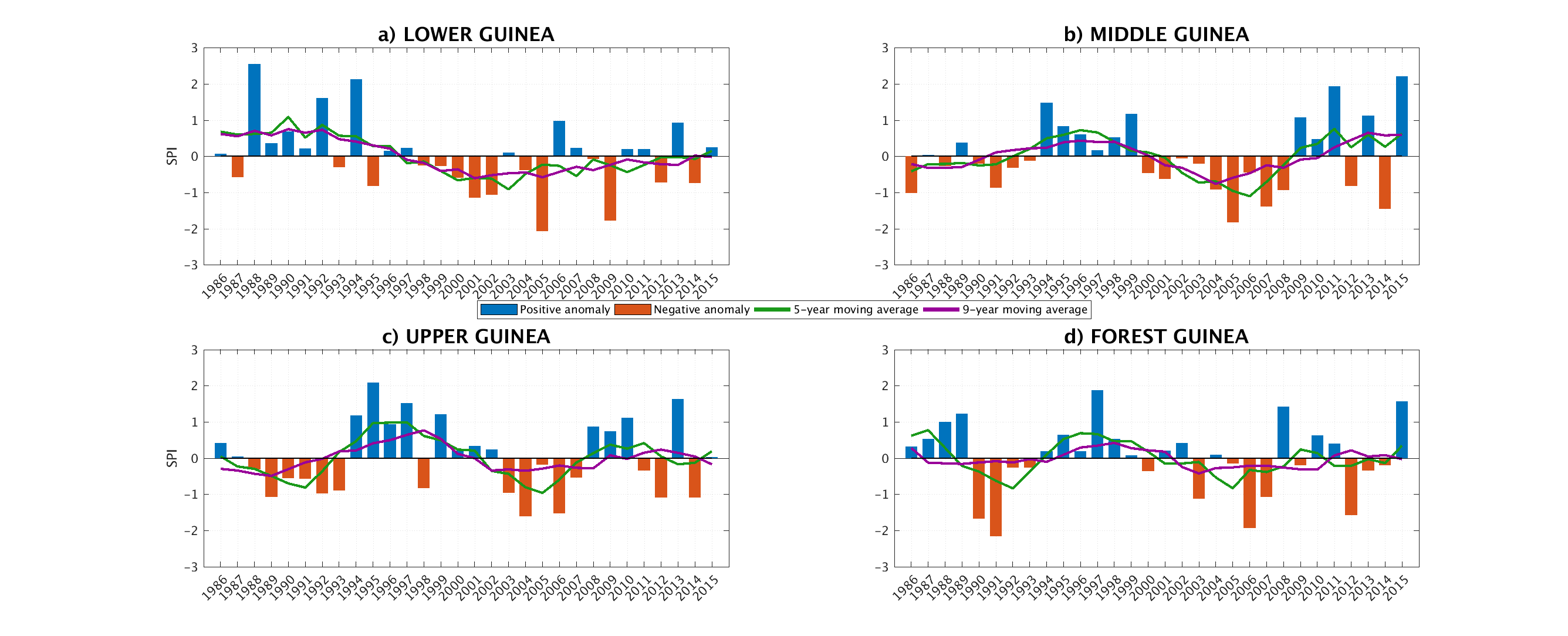
Figure 3a, Figure 3b, Figure 3c, and Figure 3d highlight the pronounced spatio-temporal variability of rainfall across the Republic of Guinea, characterized by alternating positive anomalies (wet years shown in blue) and negative anomalies (dry years shown in orange). The analysis of 5-year and 9-year moving averages reveals distinct regional rainfall dynamics. In Lower Guinea (Figure 3a), the first decade (1986–1995) was predominantly wet, followed by a prolonged dry phase extending from 1997 to 2015, marked by significant rainfall deficits, particularly in 2005 and 2009. In contrast, Middle Guinea (Figure 3b) and Upper Guinea (Figure 3c) exhibit broadly similar large-scale behavior: both regions began with dry conditions during the late 1980s, shifted toward a wetter phase in the mid-1990s, with a major peak in 1995, experienced renewed drought conditions during the 2000s, and subsequently underwent a marked recovery of above-normal rainfall after 2008.
Forest Guinea (Figure 3d), however, displays a distinctive rainfall evolution closely associated with its southern geographical location and sub-equatorial climate. Its time series reveals an abrupt transition from a markedly wet period (1986–1989) to severe drought conditions during the early 1990s, characterized by the most intense deficits recorded nationwide in 1990 and 1991 (SPI < -2). Following a relatively wet recovery phase between 1995 and 2000, the region returned to a state of chronic instability throughout the 2000s and 2010s. These findings demonstrate that although Guinea is influenced by large-scale climatic fluctuations affecting West Africa, topographic barriers together with local oceanic and forest-related forcings partition the country into distinct microclimatic zones. This regionalization generates substantial temporal disparities in both the onset and intensity of rainfall breakpoints from one region to another.

The statistical analysis of rainfall breakpoints in the Republic of Guinea during the JAS season (1986–2015) highlights a pronounced spatio-temporal heterogeneity in climatic transition regimes, reflecting a marked regionalization of rainfall dynamics under the combined influence of topographic controls, regional atmospheric circulation patterns, and the variability of the West African monsoon (Table 1). The Maurice Pettitt and Damien Lee & Heghinian tests consistently identify a significant breakpoint during the mid-1990s in Lower Guinea (1994) and Upper Guinea (1993), suggesting a relatively abrupt shift in rainfall conditions within these regions. In contrast, the discrepancies observed in Middle Guinea and Forest Guinea likely indicate the presence of more complex multi-decadal fluctuations or gradual transitions characterized by weak non-stationary changes. Quantitative analysis based on the segmentation approach of Pierre Hubert further reveals a geographical opposition between the northern/coastal regions and the inland/forest regions: Lower Guinea and Middle Guinea exhibit an increase in mean rainfall totals after the breakpoint (positive relative variation), whereas Upper Guinea and Forest Guinea experience a decline in precipitation amounts (negative relative variation). Nevertheless, the most prominent climatic signal lies in the generalized increase in interannual rainfall variability after the breakpoint, evidenced by the systematic rise in standard deviations (σ2 > σ1) across all regions (Table 1). This amplification of variability reflects an intensification of hydroclimatic extremes and an increased instability of the West African monsoon system, indicating a progressive transition toward a more irregular, contrasted, and less predictable rainfall regime.
In Table 1, the symbols are defined as follows: m1: mean of sub-period 1 (before the breakpoint), expressed in mm/year (annual mean precipitation).
m2: mean of sub-period 2 (after the breakpoint), expressed in mm/year.
σ1: standard deviation of sub-period 1, expressed in mm/year, representing interannual precipitation variability before the breakpoint.
σ2: standard deviation of sub-period 2, expressed in mm/year, representing interannual precipitation variability after the breakpoint.
VR (%): relative variation rate between the two sub-periods, computed as:
VR= [ (m2 − m1 ) / m1 ] × 100
It quantifies the magnitude of change between the two rainfall regimes.
The reported breakpoint years (Pettitt, Lee & Heghinian, Hubert) correspond to statistically significant structural changes detected in annual precipitation series.
All statistics are based on annual precipitation data (1986–2015) derived from CHIRPS v2.0 dataset.
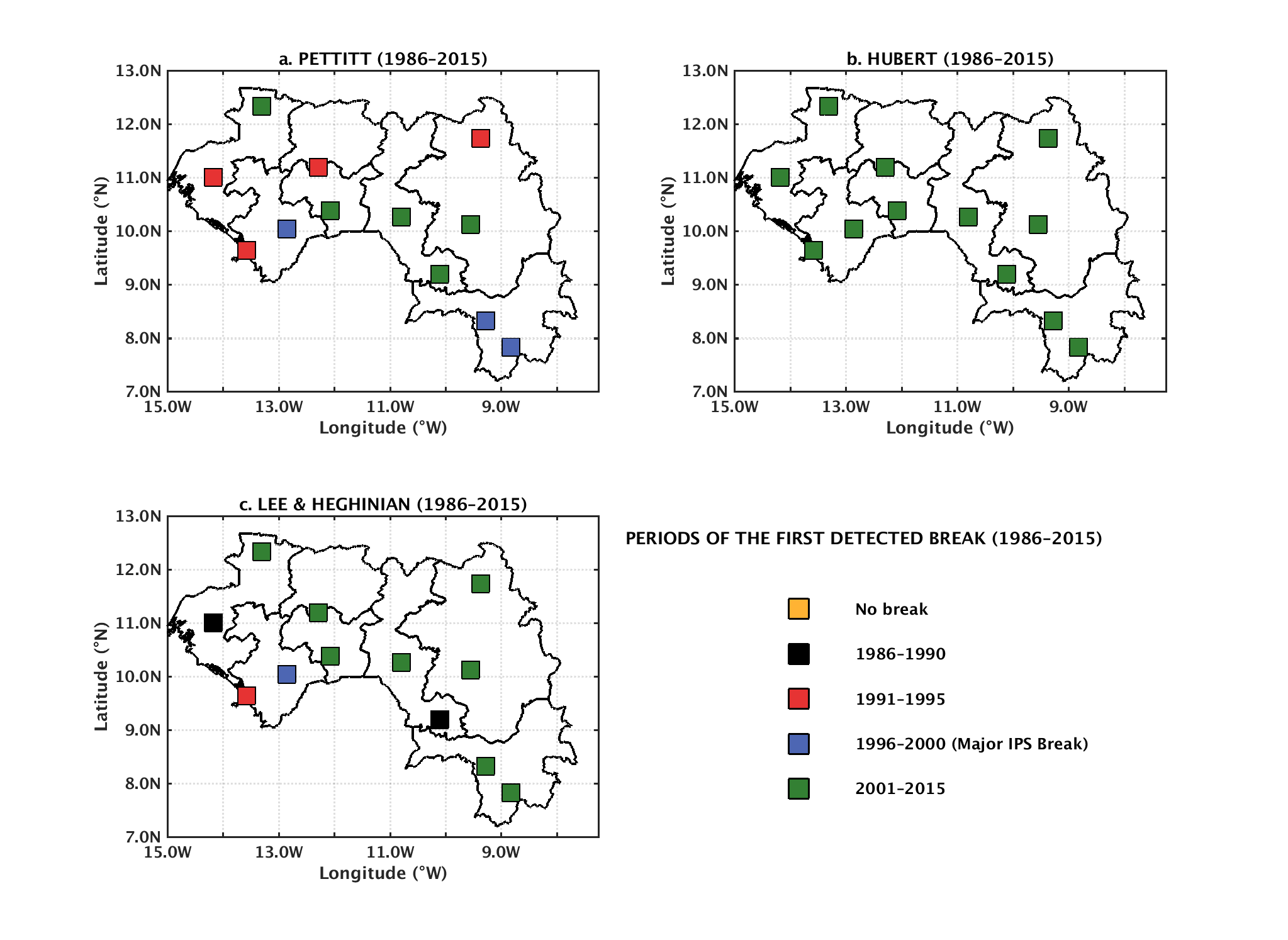
Figure 4 presents an in-depth analysis of the detection of annual rainfall change points in the Republic of Guinea over the period 1986–2015, based on the application of three complementary statistical tests (Pettitt, Hubert, and Lee & Heghinian). Each station is represented by a square whose color indicates either the detected change period or the absence of a change, according to a structured temporal classification (1986–1990, 1991–1995, 1996–2000 corresponding to the major IPS shift, 2001–2015, or no detected change). Overall, the results show strong consistency among the different methods, with a dominant concentration of change points occurring in the late 1990s and early 2000s. This period corresponds to a major climatic transition phase in Guinea, generally associated with a reorganization of rainfall regimes across West Africa.
The Hubert test stands out by providing a clearer spatial structure, highlighting a more pronounced homogeneity of late change points, mainly between 2001 and 2015. This pattern suggests the gradual establishment of a relatively stable new rainfall regime following the transition phase. In contrast, the Pettitt and Lee & Heghinian tests reveal greater interregional variability, with earlier change points detected in certain stations, particularly in Lower Guinea and Middle Guinea, where shifts are observed as early as 1986–1995. This spatial heterogeneity reflects the combined influence of local climatic gradients, oceanic proximity, and teleconnection forcing on rainfall variability.
Overall, these results indicate that the climatic shift in Guinea is neither synchronous nor spatially uniform, but is broadly centered on the late twentieth and early twenty-first centuries. They thus highlight the existence of a significant structural change in precipitation dynamics, characterized by a long-term reorganization of the national rainfall regime.

The analysis of the second rainfall break identified over the sub-period 1999–2015 highlights a delayed, spatially heterogeneous, and temporally asynchronous phase of climatic adjustment across the regions of Guinea (Table 2). This evolution is characterized by a dominant decreasing trend in rainfall totals over the post-break segments, reflecting a significant reorganization of the precipitation regime. The Pettitt and Lee & Heghinian statistical tests converge toward a clear break around 2005 in Lower Guinea, whereas later or more dispersed breakpoints are identified in Forest Guinea and at the national scale (2007 and 2014, respectively), confirming the persistence of strong spatio-temporal variability in rainfall signals.
From a quantitative perspective, the segmentation obtained using Hubert’s method (Series 3) reveals an overall degradation or stagnation of mean precipitation values compared to previous periods. This pattern is particularly pronounced in Lower Guinea, where the relative variation rate reaches −9.5% (VR2), indicating a significant decline in rainfall amounts (Table 2). In contrast, Upper Guinea exhibits a short-lived positive anomaly (+5.0% for VR2), followed by a renewed decrease (−7.2% for VR3), highlighting persistent instability in the rainfall signal.
The most critical aspect of this analysis lies in the persistence of high standard deviation values (σ₃) across the entire territory, particularly 5.7 in Lower Guinea and 3.7 in Forest Guinea (Table 2). This sustained variability indicates that the second break does not lead to a stabilization of the rainfall regime. Instead, it reflects a continued state of hydro-climatic instability characterized by alternating episodes of intense precipitation extremes, thereby reinforcing climatic uncertainty at both regional and national scales.
In Table 2, the symbols are defined as follows:
• m₃: mean value of the time series (e.g., precipitation or the considered climatic index) corresponding to the third homogeneous sub-period identified using
the Hubert segmentation method. It is expressed in the same physical unit as the studied variable (e.g., mm for precipitation).
• σ₃: standard deviation of the third sub-period. It measures the intra-period variability around the mean value m₃ and is expressed in the same unit as the analyzed variable.
• R.V 2 and R.V 3 (Relative Variations): relative changes (%) between successive sub-periods detected by the segmentation procedure. They quantify the magnitude of shifts between consecutive climatic regimes and are expressed in percentage (%).
• Break dates (Pettitt, Lee & Heghinian, Hubert tests): years of statistically significant change points identified using non-parametric change-point detection methods. Each method independently estimates the timing of shifts in the precipitation regime.
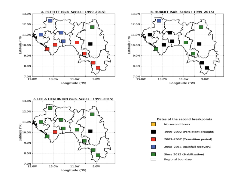
The high-resolution spatial cartographic analysis of the second rainfall breaks (1999–2015) reveals a pronounced asynchrony in the adjustment dynamics of the West African monsoon system, reflecting a clear climatic compartmentalization driven by local topographic and geographical controls (Figure 5). The Pettitt test (Figure 5a) highlights an early vulnerability of the coastal (Lower Guinea) and southern (Forest Guinea) zones, characterized by a dominant shift during the transition period 2003–2007. This pattern indicates a rapid structural reorganization of oceanic moisture inputs, as well as a significant feedback from vegetation cover dynamics. In contrast, the Fouta Djallon highlands and the eastern plains of Upper Guinea exhibit stronger temporal resilience. The Lee & Heghinian test (Figure 5c) identifies much later breakpoints in these regions, mainly occurring during the recovery phase (2008–2011) or the post-2012 stabilization period, confirming that inland areas respond more slowly to regional synoptic-scale variability.

From a methodological perspective, the comparison of algorithms underscores their differential sensitivity to hydro-climatic signals of varying frequencies. The Hubert segmentation method (Figure 5b) is characterized by a near-generalized detection of early breaks during the 1999–2002 sub-period, consistent with the thermal anomaly and widespread rainfall deficit that affected sub-Saharan Africa at the turn of the century. In contrast, the predominance of late signatures (post-2012) in the Lee & Heghinian framework highlights more gradual transitions and a tendency toward relatively more stable hydro-climatic conditions toward the end of the series.
Overall, these cartographic results demonstrate that the second phase of climatic reorganization in Guinea is not uniform. It is driven first by an immediate response of continental ecosystems to the 2000 drought, followed by a deeper atmospheric and hydrological adjustment in coastal and forested regions during the mid-2000s, and finally by the establishment of a general stabilization phase after 2012.
The analyses of standardized precipitation indices (SPI) reveal a clear alternation of wet and dry phases across Guinea, together with a pronounced reorganization of rainfall regimes starting in the mid-1990s. The breakpoint analyses obtained from the Pettitt, Buishand, and Hubert segmentation tests consistently indicate that rainfall variability is dominated by abrupt shifts rather than gradual transitions. These results are consistent with previous investigations across West Africa, which have documented significant discontinuities in hydroclimatic time series associated with large-scale climate reconfigurations (e.g. 6, 7). The timing of these structural breaks is also broadly consistent with the post-Sahelian drought recovery phase, during which major modifications of the West African monsoon system and rainfall recovery dynamics have been widely reported (e.g. 1, 2).
Although the presence of climatic breakpoints aligns with earlier regional studies, the present work further demonstrates that their magnitude, timing, and hydroclimatic consequences vary markedly across Guinea’s four natural regions. Coastal environments in Lower Guinea, mountainous terrains in Middle Guinea, continental conditions in Upper Guinea, and humid forest ecosystems in Forest Guinea exhibit distinct rainfall responses to the detected climatic shifts. These spatial contrasts highlight that Guinea cannot be treated as a climatically homogeneous entity, as precipitation variability is strongly modulated by local physiographic controls, altitude gradients, land cover characteristics, and the proximity to oceanic influences. In this regard, the present findings extend previous West African-scale studies by explicitly quantifying intra-national heterogeneity in rainfall regime changes.
Another key result is the marked intensification of rainfall variability following the identified breakpoints. The increase in post-break standard deviations indicates a progressive destabilization of the rainfall regime, characterized by more irregular and less predictable precipitation patterns. Similar increases in hydroclimatic variability have been reported in recent studies of the West African monsoon system, where enhanced fluctuations have been linked to stronger internal climate variability and a rise in extreme hydroclimatic events (e.g. 10, 11, 12, 13, 14, 15, 16). This suggests that recent climate evolution in Guinea affects not only mean precipitation conditions but also the stability and persistence of rainfall regimes, with important implications for agricultural productivity, water resource management, and ecosystem resilience.
The identification of a secondary transition phase spanning approximately 1999–2015 further underscores the complexity of rainfall evolution in Guinea. Rather than a uniform post-break recovery, the results reveal asynchronous and regionally differentiated responses across the country. Lower Guinea and Upper Guinea generally experienced stagnation or decline in rainfall conditions after the breakpoints, whereas Forest Guinea displayed higher sensitivity to climatic perturbations, reflected in stronger interannual fluctuations. These divergent trajectories suggest that the response of rainfall to large-scale atmospheric and oceanic forcing is strongly mediated by regional environmental characteristics and by nonlinear interactions between circulation systems and surface conditions. Consequently, rainfall evolution in Guinea appears to result from multiple interacting processes rather than a single dominant climatic driver.
The main originality of this study lies in its integrated, multi-method assessment of rainfall variability across all four natural regions of Guinea. By combining standardized precipitation indices with several complementary breakpoint detection techniques, the analysis provides a robust and internally consistent identification of hydroclimatic transitions. While most previous research has focused on Sahelian contexts or on long-term trend detection at broader spatial scales, this study offers a detailed national-scale perspective that explicitly resolves spatial heterogeneity in abrupt rainfall changes. In addition, the comparative analysis of pre- and post-break periods provides new evidence of a progressive fragmentation of rainfall regimes across Guinea, a feature that has been only marginally addressed in earlier literature.
Overall, the results demonstrate that Guinea has experienced a substantial reorganization of its rainfall regime over recent decades, characterized by increasing spatial differentiation and enhanced interannual variability. These findings reinforce the view that hydroclimatic transitions in West Africa are neither spatially uniform nor temporally synchronous. They also provide a stronger scientific basis for improving climate monitoring frameworks, refining regional rainfall predictability, and supporting the development of targeted adaptation strategies adapted to the diverse environmental and socio-economic contexts of Guinea.
The results of this study reveal a pronounced reorganization of the rainfall regime in the Republic of Guinea over the 1986–2015 period. The analysis of standardized precipitation indices (SPI), combined with multiple statistical breakpoint detection techniques, consistently identifies the emergence of major climatic transitions from the mid-1990s onward. These transitions reflect a significant alteration in the statistical structure of rainfall time series, indicating that precipitation variability is governed by abrupt regime shifts rather than smooth or gradual evolution.
Importantly, these changes exhibit strong spatial heterogeneity across the national territory. The four natural regions of Guinea display distinct hydroclimatic responses, shaped by the combined effects of latitudinal positioning, topographic contrasts, proximity to the Atlantic Ocean, and interactions between mesoscale and large-scale atmospheric circulation. As a result, coastal zones, the Fouta Djallon highlands, the Upper Guinea savannah, and the Forest Guinea domain emerge as differentiated climatic sub-systems, each characterized by specific rainfall variability patterns and breakpoint structures.
The analysis further reveals a significant intensification of interannual rainfall variability following the detected breakpoints, as evidenced by increased variance and a higher frequency of extreme precipitation events. This evolution suggests a progressive destabilization of the Guinean hydroclimatic system since the late 1990s, with rainfall becoming more irregular and less predictable. In addition, the secondary transition phase identified between approximately 1999 and 2015 indicates a delayed and spatially asynchronous adjustment of rainfall regimes, often manifested by stagnation or decline in precipitation totals in several regions. Overall, these results support the interpretation that rainfall evolution in Guinea reflects a structural reconfiguration of the climate system rather than a simple monotonic trend.
Beyond the diagnostic characterization of rainfall variability, this study contributes to hydroclimatic research in West Africa by integrating standardized precipitation indices with multiple complementary breakpoint detection methods. This combined methodological framework enhances the robustness of abrupt change detection and allows a more precise assessment of the timing, magnitude, and spatial differentiation of rainfall regime shifts. In doing so, the study fills an important gap in the literature, as national-scale analyses explicitly addressing hydroclimatic discontinuities in Guinea remain limited.
From an applied perspective, the findings carry significant implications for climate risk management and sectoral planning. The identification of region-specific rainfall regime shifts provides critical information for improving water resource management, including reservoir operation, watershed regulation, groundwater recharge assessment, and the mitigation of flood and drought hazards. In the agricultural sector, these results may support the adjustment of cropping calendars, the selection of climate-resilient crop varieties, and the optimization of irrigation strategies in response to increasing rainfall variability. More broadly, the strong spatial contrasts observed in rainfall behaviour underscore the need for differentiated adaptation strategies that account for the specific hydroclimatic conditions of each natural region, rather than uniform national approaches.
These findings are also relevant for strengthening climate services and early warning systems in Guinea. Incorporating the identified rainfall regime shifts into seasonal forecasting frameworks, hydrological planning, and disaster risk reduction strategies would improve preparedness and enhance the resilience of vulnerable populations to hydroclimatic extremes. In this sense, the results provide an evidence-based foundation for climate-resilient development and support informed decision-making in sectors highly dependent on rainfall variability.
Finally, future research should focus on elucidating the physical mechanisms underlying these abrupt changes by explicitly examining the role of ocean–atmosphere interactions, including sea surface temperature anomalies in the tropical Atlantic, the El Niño–Southern Oscillation (ENSO), the Indian Ocean Dipole (IOD), and other relevant climate teleconnection patterns. The combination of statistical approaches with regional climate modelling and high-resolution satellite datasets would further improve understanding of rainfall variability processes in Guinea and enhance the ability to anticipate future hydroclimatic changes under different climate change scenarios.
The authors would like to express their sincere gratitude to all the institutions and research laboratories that contributed to the realization of this study entitled “Spatio-temporal analysis of annual rainfall breakpoints in the Republic of Guinea (West Africa)”. Special thanks are addressed to the High Institute for Education Sciences of Guinea (ISSEG), the Laboratory for Teaching and Research in Applied Energy (LEREA) at Gamal Abdel Nasser University of Conakry (UGANC), the Siméon Fongang Laboratory of Atmospheric and Ocean Physics (LPAO-SF) at Cheikh Anta Diop University of Dakar (UCAD), the National Directorate of Meteorology (DNM) of Guinea, the Institute for Environmental Research of Guinea (IREG), the Institute for Science and Technology of Mamou (IST), the University of Labé (UL), the University of N'Zérékoré (UZ), and the City of Science and Innovation of Guinea (CSIG) for their scientific, technical, and institutional support.
The authors also sincerely acknowledge all researchers, collaborators, and technical staff who contributed to data collection, processing, and scientific discussions that significantly improved the quality of this work. Particular appreciation is extended to the meteorological services and research teams involved in the provision and management of climatic data used in this study.
Finally, the authors express their profound gratitude to their academic supervisors, colleagues, and partner institutions for their continuous guidance, encouragement, and valuable scientific contributions throughout the completion of this research work.
| [1] | Nicholson, S. E., “The West African Sahel: A review of recent studies on the rainfall regime and its interannual variability,” Wiley Interdisciplinary Reviews: Climate Change, 4(1). 17–27. 2013. | ||
| In article | View Article | ||
| [2] | Sultan, B. and Gaetani, M., “Agriculture in West Africa in the twenty-first century: Climate change and impacts uncertainties,” Frontiers in Plant Science, 7. 2072. 2016. | ||
| In article | View Article PubMed | ||
| [3] | Lamb, P. J., “West African water vapor variability and its relation to rainfall,” Monthly Weather Review, 111(8). 1720–1734. 1983. | ||
| In article | |||
| [4] | Nicholson, S. E., “Sub-Saharan rainfall: 1951–1983,” Journal of Climate and Applied Meteorology, 24(2). 1388–1409. 1985. | ||
| In article | View Article | ||
| [5] | Paturel, J. E., Servat, E., Kouamé, B., Boyer, J. F., Lubès-Niel, H. and Masson, J. M., “Climatic variability in humid Africa along the Gulf of Guinea. Part II: An integrated regional approach,” Journal of Hydrology, 191(1–4). 56–91. 1997. | ||
| In article | View Article | ||
| [6] | Hubert, P., Carbonnel, J. P. and Chaouche, A., “Segmentation des séries hydrométéorologiques. Application à des séries de précipitations et de débits de l’Afrique de l’Ouest,” Journal of Hydrology, 110(3–4). 349–367. 1989. | ||
| In article | View Article | ||
| [7] | Pettitt, A. N., “A non-parametric approach to the change-point problem,” Applied Statistics, 28(2). 126–135. 1979. | ||
| In article | View Article PubMed | ||
| [8] | Lubès-Niel, H., Masson, J. M., Paturel, J. E. and Servat, E., “Variabilité climatique et statistiques des ruptures dans les séries hydrologiques en Afrique de l’Ouest et centrale,” Hydrological Sciences Journal, 43(6). 937–950. 1998. | ||
| In article | View Article | ||
| [9] | Lee, S. and Heghinian, S. M., “A shift-of-mean level detection method for non-stationary time series,” Water Resources Research, 13(6). 1401–1409. 1977. | ||
| In article | |||
| [10] | Mahé, G. and Olivry, J. C., “Assessment of freshwater yields to the ocean along the West and Central African coasts,” Hydrological Sciences Journal, 44(6). 941–953. 1999. | ||
| In article | |||
| [11] | Diallo, I., Giorgi, F. and Deme, A., “Rainfall variability and climate change in Guinea: Trends and extreme events,” Climate Research, 56(2). 123–137. 2013. | ||
| In article | |||
| [12] | Kante, I. K., Badiane, D., Diaby, I. and Diouf, I., “Seasonal variability of rainfall and thunderstorm in Guinea over the period 1981 to 2010,” African Journal of Environmental Science and Technology, 13(9). 324–341. 2019. | ||
| In article | View Article | ||
| [13] | Traore, M. M., Wane, D., Camara, I., Millimono, T. N., Kanté, I. K., Barry, M. B., ... and Sall, S. M., “Characterization of Precipitation Indices in the Republic of Guinea Using In-Situ Data,” 2025. | ||
| In article | View Article | ||
| [14] | Gourou, P., La terre et l’homme en Afrique, Flammarion, Paris, 1962. | ||
| In article | |||
| [15] | Béavogui, K., Camara, M. and Diallo, A., “Variabilité des précipitations et jours de pluie en Guinée forestière,” Revue des Sciences de l’Eau et du Climat en Afrique de l’Ouest, 5(2). 45–58. 2011. | ||
| In article | |||
| [16] | Paturel, J. E., Servat, E., Kouamé, B., Boyer, J. F., Lubès-Niel, H. and Masson, J. M., “Climatic variability in humid Africa along the Gulf of Guinea. Part II: An integrated regional approach,” Journal of Hydrology, 191(1–4). 56–91. 1997. | ||
| In article | View Article | ||
Published with license by Science and Education Publishing, Copyright © 2026 Diakaria Diallo, Moussa Mamady Traore, Tamba Nicolas Millimono, Mamadou Bailo Barry, Ibrahima Kalil Kanté, Mamadou Keita, Hambaliou Balde, Bakary Traore, Abdoulaye Baniré Diallo, Maoro Beavogui and Idrissa Diaby
 This work is licensed under a Creative Commons Attribution 4.0 International License. To view a copy of this license, visit
http://creativecommons.org/licenses/by/4.0/
This work is licensed under a Creative Commons Attribution 4.0 International License. To view a copy of this license, visit
http://creativecommons.org/licenses/by/4.0/
| [1] | Nicholson, S. E., “The West African Sahel: A review of recent studies on the rainfall regime and its interannual variability,” Wiley Interdisciplinary Reviews: Climate Change, 4(1). 17–27. 2013. | ||
| In article | View Article | ||
| [2] | Sultan, B. and Gaetani, M., “Agriculture in West Africa in the twenty-first century: Climate change and impacts uncertainties,” Frontiers in Plant Science, 7. 2072. 2016. | ||
| In article | View Article PubMed | ||
| [3] | Lamb, P. J., “West African water vapor variability and its relation to rainfall,” Monthly Weather Review, 111(8). 1720–1734. 1983. | ||
| In article | |||
| [4] | Nicholson, S. E., “Sub-Saharan rainfall: 1951–1983,” Journal of Climate and Applied Meteorology, 24(2). 1388–1409. 1985. | ||
| In article | View Article | ||
| [5] | Paturel, J. E., Servat, E., Kouamé, B., Boyer, J. F., Lubès-Niel, H. and Masson, J. M., “Climatic variability in humid Africa along the Gulf of Guinea. Part II: An integrated regional approach,” Journal of Hydrology, 191(1–4). 56–91. 1997. | ||
| In article | View Article | ||
| [6] | Hubert, P., Carbonnel, J. P. and Chaouche, A., “Segmentation des séries hydrométéorologiques. Application à des séries de précipitations et de débits de l’Afrique de l’Ouest,” Journal of Hydrology, 110(3–4). 349–367. 1989. | ||
| In article | View Article | ||
| [7] | Pettitt, A. N., “A non-parametric approach to the change-point problem,” Applied Statistics, 28(2). 126–135. 1979. | ||
| In article | View Article PubMed | ||
| [8] | Lubès-Niel, H., Masson, J. M., Paturel, J. E. and Servat, E., “Variabilité climatique et statistiques des ruptures dans les séries hydrologiques en Afrique de l’Ouest et centrale,” Hydrological Sciences Journal, 43(6). 937–950. 1998. | ||
| In article | View Article | ||
| [9] | Lee, S. and Heghinian, S. M., “A shift-of-mean level detection method for non-stationary time series,” Water Resources Research, 13(6). 1401–1409. 1977. | ||
| In article | |||
| [10] | Mahé, G. and Olivry, J. C., “Assessment of freshwater yields to the ocean along the West and Central African coasts,” Hydrological Sciences Journal, 44(6). 941–953. 1999. | ||
| In article | |||
| [11] | Diallo, I., Giorgi, F. and Deme, A., “Rainfall variability and climate change in Guinea: Trends and extreme events,” Climate Research, 56(2). 123–137. 2013. | ||
| In article | |||
| [12] | Kante, I. K., Badiane, D., Diaby, I. and Diouf, I., “Seasonal variability of rainfall and thunderstorm in Guinea over the period 1981 to 2010,” African Journal of Environmental Science and Technology, 13(9). 324–341. 2019. | ||
| In article | View Article | ||
| [13] | Traore, M. M., Wane, D., Camara, I., Millimono, T. N., Kanté, I. K., Barry, M. B., ... and Sall, S. M., “Characterization of Precipitation Indices in the Republic of Guinea Using In-Situ Data,” 2025. | ||
| In article | View Article | ||
| [14] | Gourou, P., La terre et l’homme en Afrique, Flammarion, Paris, 1962. | ||
| In article | |||
| [15] | Béavogui, K., Camara, M. and Diallo, A., “Variabilité des précipitations et jours de pluie en Guinée forestière,” Revue des Sciences de l’Eau et du Climat en Afrique de l’Ouest, 5(2). 45–58. 2011. | ||
| In article | |||
| [16] | Paturel, J. E., Servat, E., Kouamé, B., Boyer, J. F., Lubès-Niel, H. and Masson, J. M., “Climatic variability in humid Africa along the Gulf of Guinea. Part II: An integrated regional approach,” Journal of Hydrology, 191(1–4). 56–91. 1997. | ||
| In article | View Article | ||